Геопространственные данные Организации Объединенных Наций (Геоданные) — это всемирный набор геопространственных данных Организации Объединенных Наций.
Геоданные Организации Объединенных Наций предоставляются для содействия подготовке картографических материалов в Организации Объединенных Наций и включают геометрию, атрибуты и метки для содействия адекватному изображению и наименованию географических объектов для подготовки карт в соответствии с политикой и практикой Организации Объединенных Наций.
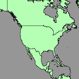
Геопространственный набор данных включает полигоны/территории стран (BNDA_simplified). Подробнее см. на этой странице .
Схема таблицы
Схема таблицы
Имя
Тип
Описание
адмисо
НИТЬ
Код ISO-3166 alpha-3 администратора области.
geo_cd
ИНТ
Код географического региона ООН M49
георег
НИТЬ
Географический регион ООН M49
глобалид
НИТЬ
GlobalID
globalid_1
НИТЬ
GlobalID_1
int_cd
НИТЬ
Промежуточный региональный код ООН M49; 0, если не установлен
интрег
НИТЬ
Промежуточный регион ООН M49; пусто, если «int_cd» равен 0
iso2cd
НИТЬ
Код ISO-3166 альфа-2
iso3cd
НИТЬ
Код ISO-3166 альфа-3
lbl_en
НИТЬ
Картографическая этикетка (английский)
lbl_fr
НИТЬ
Картографическая этикетка (французский)
m49_cd
НИТЬ
Код страны или города ООН M49
nam_en
НИТЬ
Имя (английское)
имя_fr
НИТЬ
Имя (французское)
объектид
НИТЬ
Внутренний идентификационный номер объекта
st_area_sh
ДВОЙНОЙ
Общая площадь геометрии
stscod
ИНТ
Код статуса суверенитета:
0: Антарктида
1: Состояние
2: Оккупированная палестинская территория
3: Несамоуправляющаяся территория
4: Территория
5: Особый регион или провинция
99: Не определено
sub_cd
ИНТ
Код субрегиона ООН M49
субрег
НИТЬ
Субрегион ООН M49
Условия эксплуатации
Геоданные ООН — это глобальная геопространственная база данных, доступная Секретариату ООН и внешним пользователям. Её можно использовать в различных целях, но коммерческое использование запрещено. ООН сохраняет за собой право собственности на данные, и пользователи обязаны указывать ООН как источник при создании своих материалов. Данные предоставляются «как есть» без каких-либо гарантий, и ООН не несёт ответственности за какой-либо ущерб или убытки, возникшие в результате их использования. Для получения дополнительной информации см. эту страницу .
Геопространственные данные Организации Объединенных Наций (Геоданные) – это глобальный набор геопространственных данных Организации Объединенных Наций. Геоданные Организации Объединенных Наций предоставляются для облегчения подготовки картографических материалов в Организации Объединенных Наций и включают геометрические данные, атрибуты и метки, облегчающие адекватное отображение и наименование географических объектов для…
[null,null,[],[[["\u003cp\u003eThe UN Geodata dataset provides worldwide geospatial data, including country boundaries, for cartographic purposes.\u003c/p\u003e\n"],["\u003cp\u003eThe dataset includes geometry, attributes, and labels for depicting and naming geographic features according to UN policies.\u003c/p\u003e\n"],["\u003cp\u003eThis dataset is available for non-commercial use with proper attribution to the UN; detailed terms of use are provided.\u003c/p\u003e\n"],["\u003cp\u003eUsers can explore the dataset through Google Earth Engine, which offers tools for analysis and visualization.\u003c/p\u003e\n"],["\u003cp\u003eThe data schema includes information such as country codes, names in English and French, geographic regions, and sovereignty status.\u003c/p\u003e\n"]]],["The United Nations Geospatial Data (Geodata) dataset, provided by the United Nations Geospatial, is available from February 11-12, 2023. It includes global geospatial data with polygons/areas of countries (BNDA_simplified), geometry, attributes, and labels for map creation. The dataset, accessible via Google Earth Engine, has a defined table schema, includes ISO, M49 and GlobalID codes, and is free for research, education, and nonprofit use, but commercial use is prohibited. The UN must be credited as the data source.\n"],null,["# United Nations Geospatial Data: BNDA_simplified\n\nDataset Availability\n: 2023-02-11T00:00:00Z--2023-02-12T00:00:00Z\n\nDataset Provider\n:\n\n\n [United Nations Geospatial](https://geoportal.un.org/arcgis/home/user.html?user=United_Nations_Geospatial)\n\nTags\n:\n[borders](/earth-engine/datasets/tags/borders) [countries](/earth-engine/datasets/tags/countries) [infrastructure-boundaries](/earth-engine/datasets/tags/infrastructure-boundaries) [table](/earth-engine/datasets/tags/table) \n\n#### Description\n\nThe United Nations Geospatial Data, or Geodata, is a worldwide geospatial\ndataset of the United Nations.\n\nThe United Nations Geodata is provided to facilitate the preparation of\ncartographic materials in the United Nations includes geometry, attributes\nand labels to facilitate the adequate depiction and naming of geographic\nfeatures for the preparation of maps in accordance with United Nations\npolicies and practices.\n\nThe geospatial dataset include polygons/areas of countries\n(BNDA_simplified). Please refer this [page](https://geoportal.un.org/arcgis/home/item.html?id=e4ee80edac9d4e08b8303522dd4a5fc1)\nfor more information.\n\n### Table Schema\n\n**Table Schema**\n\n| Name | Type | Description |\n|------------|--------|---------------------------------------------------------------------------------------------------------------------------------------------------------------------------------------------|\n| admiso | STRING | ISO-3166 alpha-3 code of the area's administrator. |\n| geo_cd | INT | UN M49 geographical region code |\n| georeg | STRING | UN M49 geographic region |\n| globalid | STRING | GlobalID |\n| globalid_1 | STRING | GlobalID_1 |\n| int_cd | STRING | UN M49 intermediary region code; 0 if unset |\n| intreg | STRING | UN M49 intermediary region; empty if \"int_cd\" is 0 |\n| iso2cd | STRING | ISO-3166 alpha-2 code |\n| iso3cd | STRING | ISO-3166 alpha-3 code |\n| lbl_en | STRING | Cartographic label (English) |\n| lbl_fr | STRING | Cartographic label (French) |\n| m49_cd | STRING | UN M49 country or area code |\n| nam_en | STRING | Name (English) |\n| name_fr | STRING | Name (French) |\n| objectid | STRING | Internal object ID number |\n| st_area_sh | DOUBLE | Total area of the geometry |\n| stscod | INT | Sovereignty status code: - 0: Antarctica - 1: State - 2: Occupied Palestinian Territory - 3: Non-Self Governing Territory - 4: Territory - 5: Special Region or Province - 99: Undetermined |\n| sub_cd | INT | UN M49 sub-region code |\n| subreg | STRING | UN M49 sub-region |\n\n### Terms of Use\n\n**Terms of Use**\n\nThe UN Geodata is a global geospatial database available for use by the UN\nSecretariat and external users. It can be used for various purposes, but\ncommercial use is prohibited. The UN retains ownership of the data, and\nusers must credit the UN as the source in their creations. The data is\nprovided \"as is\" without warranties, and the UN is not liable for any\ndamages or losses arising from its use. Please refer this\n[page](https://developers.google.com/earth-engine/datasets/papers/BNDA_terms_of_use.pdf)\nfor more information.\n| **Note:** Users of the Data that are not subject to the administrative instruction (\"Outside Users\") may only use the Data for the purpose for which the Data is suitable, as identified by the Geospatial Information Section upon transmission of or granting access to the Data. Intellectual property over the Data shall at all times vest with the United Nations. Intellectual property over the products created using the Data shall vest with the Outside User. The United Nations shall be recognized as the source of the Data in any products created by Outside Users using the Data, unless the Outside Users alter the Data or combine the Data with other data sets. In case of doubt regarding crediting the United Nations as the Data source, please contact: geospatial@un.org. Outside Users acknowledge that any right to access and use the Data is revocable and non-transferable. Under no circumstances may the Data be used for commercial purposes.\n\n### Explore with Earth Engine\n\n| **Important:** Earth Engine is a platform for petabyte-scale scientific analysis and visualization of geospatial datasets, both for public benefit and for business and government users. Earth Engine is free to use for research, education, and nonprofit use. To get started, please [register for Earth Engine access.](https://console.cloud.google.com/earth-engine)\n\n### Code Editor (JavaScript)\n\n```javascript\nvar dataset = ee.FeatureCollection('UN/Geodata/BNDA_simplified/current');\n\nvar styleParams = {\n fillColor: 'b5ffb4',\n color: '00909F',\n width: 1.0,\n};\n\ndataset = dataset.style(styleParams);\nMap.centerObject(dataset);\nMap.addLayer(dataset, {}, 'BNDA simplified');\n```\n[Open in Code Editor](https://code.earthengine.google.com/?scriptPath=Examples:Datasets/UN/UN_Geodata_BNDA_simplified_current) \n[United Nations Geospatial Data: BNDA_simplified](/earth-engine/datasets/catalog/UN_Geodata_BNDA_simplified_current) \nThe United Nations Geospatial Data, or Geodata, is a worldwide geospatial dataset of the United Nations. The United Nations Geodata is provided to facilitate the preparation of cartographic materials in the United Nations includes geometry, attributes and labels to facilitate the adequate depiction and naming of geographic features for the ... \nUN/Geodata/BNDA_simplified/current, borders,countries,infrastructure-boundaries,table \n2023-02-11T00:00:00Z/2023-02-12T00:00:00Z \n-90 -180 90 180 \nGoogle Earth Engine \nhttps://developers.google.com/earth-engine/datasets\n\n- [](https://doi.org/https://geoportal.un.org/arcgis/home/user.html?user=United_Nations_Geospatial)\n- [](https://doi.org/https://developers.google.com/earth-engine/datasets/catalog/UN_Geodata_BNDA_simplified_current)"]]