- Disponibilidad del conjunto de datos
- 2017-12-29T00:00:00Z–2017-12-29T00:00:00Z
- Productor del conjunto de datos
- Oficina del Geógrafo del Departamento de Estado de los Estados Unidos
- Etiquetas
Descripción
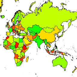
La Oficina del Geógrafo de Estados Unidos proporciona el conjunto de datos de límites internacionales a gran escala (LSIB). Se deriva de otros dos conjuntos de datos: un archivo vectorial de líneas del LSIB y las líneas costeras vectoriales mundiales (WVS) de la Agencia Nacional de Inteligencia Geoespacial (NGA). Los límites interiores reflejan las políticas del Gobierno de EE.UU. sobre límites, disputas fronterizas y soberanía. Los límites exteriores se derivan del WVS. Sin embargo, los datos de la costa del WVS están desactualizados y, por lo general, se desplazan entre varios cientos de metros y más de un kilómetro. Cada elemento es el área poligonal delimitada por los límites interiores y las costas exteriores, cuando corresponda, y muchos países constan de varios elementos, uno por cada región disjunta. Cada uno de los 180,741 atributos forma parte de la geometría de uno de los 284 países que se describen en este conjunto de datos.
Esquema de la tabla
Esquema de la tabla
| Nombre | Tipo | Descripción |
|---|---|---|
| OBJECTID | STRING | ID de objeto |
| COUNTRY_NA | STRING | Nombre del país reconocido por EE.UU. |
Condiciones de Uso
Condiciones de Uso
No hay restricciones sobre el uso de estos datos de dominio público de EE.UU.
Explora con Earth Engine
Editor de código (JavaScript)
var dataset = ee.FeatureCollection('USDOS/LSIB/2017');
var styleParams = {
  fillColor: 'b5ffb4',
  color: '00909F',
  width: 3,
};
var countries = dataset.style(styleParams);
Map.setCenter(16.35, 48.83, 4);
Map.addLayer(countries, {}, 'USDOS/LSIB/2017', true, 0.8);
Visualiza como FeatureView
Un FeatureView es una representación acelerada y de solo lectura de un FeatureCollection. Para obtener más detalles, consulta la
documentación de FeatureView.
Editor de código (JavaScript)
var fvLayer = ui.Map.FeatureViewLayer('USDOS/LSIB/2017_FeatureView');

var visParams = {
  color: '00909F',
  fillColor: 'b5ffb4',
  width: 3,
  opacity: 1
};

fvLayer.setVisParams(visParams);
fvLayer.setName('USDOS/LSIB/2017');

Map.setCenter(16.35, 48.83, 4);
Map.add(fvLayer);