- Disponibilité de l'ensemble de données
- 1924-01-01T00:00:00Z–2022-05-04T00:00:00Z
- Producteur de l'ensemble de données
- Institut d'études géologiques des États-Unis
- Tags
Description
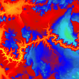
Il s'agit de l'ensemble de données DEM 3DEP continu pour les États-Unis, avec une couverture complète des 48 États contigus, d'Hawaï et des territoires américains. La couverture de l'Alaska est partiellement disponible pour le moment et sera étendue à l'ensemble de l'État dans le cadre de l'initiative de cartographie de l'Alaska. L'espacement au sol est d'environ 10 mètres nord/sud, mais il est variable est/ouest en raison de la convergence des méridiens avec la latitude.
L'ensemble de données de 1 m est ingéré sous le nom USGS_3DEP_1m.
Ensemble de données importé par Farmers Business Network.
Bandes
Bandes de fréquences
Taille des pixels : 10,2 mètres (toutes les bandes)
| Nom | Unités | Taille des pixels | Description |
|---|---|---|---|
elevation |
m | 10,2 mètres | Élévation |
Conditions d'utilisation
Conditions d'utilisation
La plupart des informations de l'Institut d'études géologiques des États-Unis (USGS) appartiennent au domaine public et peuvent être utilisées sans restriction. Des informations supplémentaires sur la façon d'indiquer ou de créditer l'USGS comme source d'informations sont disponibles.
Citations
U.S. Geological Survey, 3D Elevation Program 10-Meter Resolution Digital Elevation Model.
Explorer avec Earth Engine
Éditeur de code (JavaScript)
var dataset = ee.ImageCollection('USGS/3DEP/10m_collection')
var elevation = dataset.select('elevation');

Map.setCenter(-112.8598, 36.2841, 7);
Map.addLayer(elevation, {min: 0, max: 3000,   palette: [
    '3ae237', 'b5e22e', 'd6e21f', 'fff705', 'ffd611', 'ffb613', 'ff8b13',
    'ff6e08', 'ff500d', 'ff0000', 'de0101', 'c21301', '0602ff', '235cb1',
    '307ef3', '269db1', '30c8e2', '32d3ef', '3be285', '3ff38f', '86e26f'
  ],
}, 'elevation');