- Disponibilità set di dati
- 1998-08-16T00:00:00Z–2020-05-06T00:00:00Z
- Produttore del set di dati
- United States Geological Survey
- Tag
Descrizione
Si tratta del set di dati DEM 3DEP senza interruzioni per gli Stati Uniti con copertura completa dei 48 stati contigui, delle Hawaii e dei territori statunitensi. La copertura dell'Alaska è parzialmente disponibile ora e verrà estesa a livello statale nell'ambito dell'iniziativa di mappatura dell'Alaska. La distanza a terra è di circa 10 metri in direzione nord/sud, ma variabile in direzione est/ovest a causa della convergenza dei meridiani con la latitudine.
Il set di dati da 1 metro viene importato come USGS_3DEP_1m.
Set di dati caricato da Farmers Business Network.
Bande
Bande
Dimensioni pixel: 10,2 metri (tutte le bande)
| Nome | Unità | Dimensioni pixel | Descrizione |
|---|---|---|---|
elevation |
m | 10,2 metri | Elevazione |
Termini e condizioni d'uso
Termini e condizioni d'uso
La maggior parte delle informazioni dell'US Geological Survey (USGS) è di pubblico dominio e può essere utilizzata senza restrizioni. Sono disponibili ulteriori informazioni su Come riconoscere o citare l'USGS come fonte di informazioni.
Citazioni
U.S. Geological Survey, 3D Elevation Program 10-Meter Resolution Digital Elevation Model.
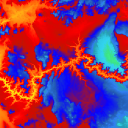
Esplora con Earth Engine
Editor di codice (JavaScript)
var dataset = ee.ImageCollection('USGS/3DEP/10m_collection')
var elevation = dataset.select('elevation');

Map.setCenter(-112.8598, 36.2841, 7);
Map.addLayer(elevation, {min: 0, max: 3000,   palette: [
    '3ae237', 'b5e22e', 'd6e21f', 'fff705', 'ffd611', 'ffb613', 'ff8b13',
    'ff6e08', 'ff500d', 'ff0000', 'de0101', 'c21301', '0602ff', '235cb1',
    '307ef3', '269db1', '30c8e2', '32d3ef', '3be285', '3ff38f', '86e26f'
  ],
}, 'elevation');