Это набор данных 3DEP DEM для США с полным покрытием 48 сопредельных штатов, Гавайев и территорий США. Покрытие Аляски уже частично доступно и расширяется до охвата всего штата в рамках программы Alaska Mapping Initiative. Расстояние между точками рельефа составляет примерно 10 метров с севера на юг, но может меняться с востока на запад из-за схождения меридианов по широте.
Большая часть информации Геологической службы США (USGS) находится в открытом доступе и может использоваться без ограничений. Дополнительная информация о том, как указать USGS как источник информации, доступна здесь.
Цитаты
Цитаты:
Геологическая служба США, Программа 3D-моделирования рельефа. Цифровая модель рельефа с разрешением 10 метров.
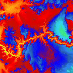
Это набор данных 3DEP DEM для США с полным покрытием 48 сопредельных штатов, Гавайев и территорий США. Покрытие Аляски уже частично доступно и расширяется до охвата всего штата в рамках программы Alaska Mapping Initiative. Расстояние между точками рельефа составляет примерно 10 метров с севера на юг, но…
[null,null,[],[],[],null,["# USGS 3DEP 10m National Map Seamless (1/3 Arc-Second)\n\nDataset Availability\n: 1998-08-16T00:00:00Z--2020-05-06T00:00:00Z\n\nDataset Provider\n:\n\n\n [United States Geological Survey](https://www.usgs.gov/core-science-systems/ngp/3dep/about-3dep-products-services)\n\nTags\n:\n[3dep](/earth-engine/datasets/tags/3dep) [dem](/earth-engine/datasets/tags/dem) [elevation](/earth-engine/datasets/tags/elevation) [elevation-topography](/earth-engine/datasets/tags/elevation-topography) [geophysical](/earth-engine/datasets/tags/geophysical) [topography](/earth-engine/datasets/tags/topography) [usgs](/earth-engine/datasets/tags/usgs) \n\n#### Description\n\nThis is the seamless 3DEP DEM dataset for the U.S.\nwith full coverage of the 48 conterminous states, Hawaii, and\nU.S. territories. Alaska coverage is partially available now and is being\nexpanded to statewide coverage as part of the Alaska Mapping Initiative.\nGround spacing is approximately 10 meters north/south, but variable\neast/west due to convergence of meridians with latitude.\n\nThe 1m dataset is ingested\nas [USGS_3DEP_1m](/earth-engine/datasets/catalog/USGS_3DEP_1m).\n\nDataset uploaded by [Farmers Business Network](https://fbn.com).\n\n### Bands\n\n**Bands**\n\n| Name | Units | Pixel Size | Description |\n|-------------|-------|-------------|-------------|\n| `elevation` | m | 10.2 meters | Elevation |\n\n### Terms of Use\n\n**Terms of Use**\n\nMost U.S. Geological Survey (USGS) information resides\nin the public domain and may be used without restriction. Additional\ninformation on [Acknowledging or Crediting USGS as Information\nSource](https://www.usgs.gov/information-policies-and-instructions/crediting-usgs)\nis available.\n\n### Citations\n\nCitations:\n\n- U.S. Geological Survey, 3D Elevation Program 10-Meter Resolution Digital Elevation Model.\n\n### Explore with Earth Engine\n\n| **Important:** Earth Engine is a platform for petabyte-scale scientific analysis and visualization of geospatial datasets, both for public benefit and for business and government users. Earth Engine is free to use for research, education, and nonprofit use. To get started, please [register for Earth Engine access.](https://console.cloud.google.com/earth-engine)\n\n### Code Editor (JavaScript)\n\n```javascript\nvar dataset = ee.ImageCollection('USGS/3DEP/10m_collection')\nvar elevation = dataset.select('elevation');\n\nMap.setCenter(-112.8598, 36.2841, 7);\nMap.addLayer(elevation, {min: 0, max: 3000, palette: [\n '3ae237', 'b5e22e', 'd6e21f', 'fff705', 'ffd611', 'ffb613', 'ff8b13',\n 'ff6e08', 'ff500d', 'ff0000', 'de0101', 'c21301', '0602ff', '235cb1',\n '307ef3', '269db1', '30c8e2', '32d3ef', '3be285', '3ff38f', '86e26f'\n ],\n}, 'elevation');\n```\n[Open in Code Editor](https://code.earthengine.google.com/?scriptPath=Examples:Datasets/USGS/USGS_3DEP_10m_collection) \n[USGS 3DEP 10m National Map Seamless (1/3 Arc-Second)](/earth-engine/datasets/catalog/USGS_3DEP_10m_collection) \nThis is the seamless 3DEP DEM dataset for the U.S. with full coverage of the 48 conterminous states, Hawaii, and U.S. territories. Alaska coverage is partially available now and is being expanded to statewide coverage as part of the Alaska Mapping Initiative. Ground spacing is approximately 10 meters north/south, but ... \nUSGS/3DEP/10m_collection, 3dep,dem,elevation,elevation-topography,geophysical,topography,usgs \n1998-08-16T00:00:00Z/2020-05-06T00:00:00Z \n-16.6 -171 76.9 164 \nGoogle Earth Engine \nhttps://developers.google.com/earth-engine/datasets\n\n- [](https://doi.org/https://www.usgs.gov/core-science-systems/ngp/3dep/about-3dep-products-services)\n- [](https://doi.org/https://developers.google.com/earth-engine/datasets/catalog/USGS_3DEP_10m_collection)"]]