Esta é uma coleção de imagens em mosaico com tamanho de pixel de 1 m do programa de elevação 3D (3DEP). Os dados do 3DEP servem como a camada de elevação do Mapa Nacional e fornecem informações básicas de elevação para estudos de ciências da Terra e aplicativos de mapeamento nos Estados Unidos.
As elevações neste DEM representam a superfície topográfica da Terra.
Os modelos digitais de elevação (DEMs) padrão do USGS com tamanho de pixel de 1 m são produzidos exclusivamente com dados de origem de detecção e alcance de luz (lidar) de alta resolução de imagens com tamanho de pixel de 1 m ou resolução maior. As superfícies de DEM com tamanho de pixel de 1 m são contínuas em projetos de coleta, mas não necessariamente entre projetos.
A referência espacial usada para blocos do DEM de 1 m de tamanho de pixel nos Estados Unidos contíguos (CONUS) é a Universal Transverse Mercator (UTM) em unidades de metros e em conformidade com o North American Datum de 1983 (NAD83). Todos os valores de elevação da terra nua estão em metros e são referenciados ao Datum Vertical da América do Norte de 1988 (NAVD88). Cada bloco é distribuído na zona UTM em que está localizado. Se um bloco cruzar duas zonas UTM, ele será entregue nas duas.
Nesses e em outros casos de sobreposição de imagens, os valores de elevação podem ser ligeiramente diferentes em imagens diferentes que cobrem a mesma área.
O DEM de tamanho de pixel de 1 m é o DEM padrão de maior resolução oferecido no conjunto de produtos 3DEP. O conjunto de dados 3DEP de 10 m está disponível em USGS_3DEP_10m.
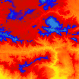
É uma coleção de imagens em mosaico com tamanho de pixel de 1 m do 3D Elevation Program (3DEP). Os dados do 3DEP servem como a camada de elevação do Mapa Nacional e fornecem informações básicas de elevação para estudos de ciências da Terra e aplicativos de mapeamento nos Estados Unidos. As elevações neste…
[null,null,[],[[["\u003cp\u003eThe USGS 3DEP 1m dataset provides elevation data for the United States with 1-meter resolution.\u003c/p\u003e\n"],["\u003cp\u003eThis dataset is primarily derived from high-resolution LiDAR data and represents bare-earth topography.\u003c/p\u003e\n"],["\u003cp\u003eElevation values are referenced to NAVD88 and the dataset is available as a tiled image collection in Earth Engine.\u003c/p\u003e\n"],["\u003cp\u003eWhile seamless within projects, tiles may have slight elevation differences where they overlap.\u003c/p\u003e\n"],["\u003cp\u003eThe dataset is freely available for research, education, and non-profit use through the USGS and Earth Engine.\u003c/p\u003e\n"]]],["The USGS 3DEP 1m dataset provides 1-meter resolution elevation data for the United States, from 2006 to 2015. Data is sourced from high-resolution lidar and is accessible via the Earth Engine using the `ee.ImageCollection(\"USGS/3DEP/1m\")` snippet. The dataset's elevations represent bare-earth surfaces referenced to the NAVD88 vertical datum, and the dataset is seamless within collection projects. Tiles use UTM projection and are available in overlapping zones. Public domain use is permitted with USGS acknowledgment.\n"],null,["# USGS 3DEP 1m National Map\n\nDataset Availability\n: 2015-01-01T00:00:00Z--2006-01-01T00:00:00Z\n\nDataset Provider\n:\n\n\n [United States Geological Survey](https://www.sciencebase.gov/catalog/item/543e6b86e4b0fd76af69cf4c)\n\nTags\n:\n[3dep](/earth-engine/datasets/tags/3dep) [dem](/earth-engine/datasets/tags/dem) [elevation](/earth-engine/datasets/tags/elevation) [elevation-topography](/earth-engine/datasets/tags/elevation-topography) [geophysical](/earth-engine/datasets/tags/geophysical) [topography](/earth-engine/datasets/tags/topography) [usgs](/earth-engine/datasets/tags/usgs) \n\n#### Description\n\nThis is a tiled collection of images with 1m pixel size from the 3D\nElevation Program (3DEP). The 3DEP data holdings serve as the elevation\nlayer of The National Map and provide foundational elevation information for\nearth science studies and mapping applications in the United States.\n\nThe elevations in this DEM represent the topographic bare-earth surface.\nUSGS standard 1m pixel size DEMs are produced exclusively from high\nresolution light detection and ranging (lidar) source data of images with 1m\npixel size or higher resolution. 1m pixel size DEM surfaces are seamless\nwithin collection projects but not necessarily seamless across projects.\nThe spatial reference used for tiles of the 1m pixel size DEM within the\nconterminous United States (CONUS) is Universal Transverse Mercator (UTM) in\nunits of meters and in conformance with the North American Datum of 1983\n(NAD83). All bare earth elevation values are in meters and are referenced to\nthe North American Vertical Datum of 1988 (NAVD88). Each tile is distributed\nin the UTM Zone in which it lies. If a tile crosses two UTM zones, it is\ndelivered in both zones.\nIn this and other cases of image overlaps, elevation values might be\nslightly different in different images covering the same area.\n\nThe 1m pixel size DEM is the highest resolution standard DEM offered in the\n3DEP product suite. The 10m 3DEP dataset is available at\n[USGS_3DEP_10m](/earth-engine/datasets/catalog/USGS_3DEP_10m).\n\n### Bands\n\n**Bands**\n\n| Name | Units | Pixel Size | Description |\n|-------------|-------|------------|--------------------|\n| `elevation` | m | 1 meters | Elevation (NAVD88) |\n\n### Terms of Use\n\n**Terms of Use**\n\nMost U.S. Geological Survey (USGS) information resides\nin the public domain and may be used without restriction. Additional\ninformation on [Acknowledging or Crediting USGS as Information\nSource](https://www.usgs.gov/information-policies-and-instructions/crediting-usgs)\nis available.\n\n### Citations\n\nCitations:\n\n- U.S. Geological Survey, 3D Elevation Program 1-Meter Resolution Digital\n Elevation Model.\n\n### Explore with Earth Engine\n\n| **Important:** Earth Engine is a platform for petabyte-scale scientific analysis and visualization of geospatial datasets, both for public benefit and for business and government users. Earth Engine is free to use for research, education, and nonprofit use. To get started, please [register for Earth Engine access.](https://console.cloud.google.com/earth-engine)\n\n### Code Editor (JavaScript)\n\n```javascript\nvar dataset = ee.ImageCollection('USGS/3DEP/1m');\nvar visualization = {\n min: 0,\n max: 3000,\n palette: [\n '3ae237', 'b5e22e', 'd6e21f', 'fff705', 'ffd611', 'ffb613', 'ff8b13',\n 'ff6e08', 'ff500d', 'ff0000', 'de0101', 'c21301', '0602ff', '235cb1',\n '307ef3', '269db1', '30c8e2', '32d3ef', '3be285', '3ff38f', '86e26f'\n ],\n};\nMap.setCenter(-119.0, 34.6, 10);\nMap.addLayer(dataset, visualization, 'elevation');\n```\n[Open in Code Editor](https://code.earthengine.google.com/?scriptPath=Examples:Datasets/USGS/USGS_3DEP_1m) \n[USGS 3DEP 1m National Map](/earth-engine/datasets/catalog/USGS_3DEP_1m) \nThis is a tiled collection of images with 1m pixel size from the 3D Elevation Program (3DEP). The 3DEP data holdings serve as the elevation layer of The National Map and provide foundational elevation information for earth science studies and mapping applications in the United States. The elevations in this ... \nUSGS/3DEP/1m, 3dep,dem,elevation,elevation-topography,geophysical,topography,usgs \n2015-01-01T00:00:00Z/2006-01-01T00:00:00Z \n-16.6 -171 76.9 164 \nGoogle Earth Engine \nhttps://developers.google.com/earth-engine/datasets\n\n- [](https://doi.org/https://www.sciencebase.gov/catalog/item/543e6b86e4b0fd76af69cf4c)\n- [](https://doi.org/https://developers.google.com/earth-engine/datasets/catalog/USGS_3DEP_1m)"]]