- זמינות קבוצת הנתונים
- 2001-01-01T00:00:00Z–2002-01-01T00:00:00Z
- מפיק מערך הנתונים
- USGS
- תגים
תיאור
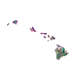
הנתונים של GAP/LANDFIRE National Terrestrial Ecosystems מייצגים סיווג מפורט של צמחייה וכיסוי קרקע בארה"ב הרציפה, אלסקה, הוואי ופוארטו ריקו. מערכות אקולוגיות של GAP/LF 2011 עבור ארה"ב הרציפה היא עדכון של נתוני כיסוי הקרקע של התוכנית הלאומית לניתוח פערים – גרסה 2.2. מערכות אקולוגיות באלסקה עודכנו על ידי LANDFIRE לתנאים של 2012 (LANDFIRE 2012). הנתונים של הוואי ופוארטו ריקו מייצגים את מסגרת הזמן של שנת 2001 (Gon et al. 2006, Gould et al. 2008). סכמת הסיווג שמשמשת לאלסקה ול-48 המדינות התחתונות מבוססת על סיווג המערכת האקולוגית של NatureServe (Comer et al. 2003), ואילו מקרא המפה של פורטו ריקו ושל הוואי מבוסס על מערכות סיווג ספציפיות לאיים (Gon et al. 2006, Gould et al. 2008).
תחום תדרים
תחום תדרים
גודל הפיקסל: 30 מטרים (כל הפסים)
| שם | מינימום | מקסימום | גודל הפיקסל | תיאור |
|---|---|---|---|---|
landcover |
1 | 9 | 30 מטרים | תיאורי הסוגים של כיסוי השטח |
טבלת סיווג של כיסוי הקרקע
| ערך | צבע | תיאור |
|---|---|---|
| 1 | #7c009c | יער מעורב של מינים מקומיים ומינים זרים |
| 2 | #c14f00 | שיחים ועשבים מעורבים מקומיים וזרים |
| 3 | #c1e09e | צמחייה מקומית לאורך החוף |
| 4 | #ef0047 | Deschampsia Grassland |
| 5 | #d67900 | Aalii Shrubland |
| 6 | #00e3eb | צמחייה בביצות |
| 7 | #ccbf70 | צמחייה מקומית על צוקים יבשים |
| 8 | #7c7047 | Native Shrubland / Sparse Ohia (native shrubs) |
| 9 | #617000 | צמחייה מקומית על צוקים רטובים |
| 10 | #66e805 | פתיחת Mao Shrubland |
| 11 | #bf6b00 | Uluhe Shrubland |
| 12 | #9bcc9b | יער האלה סגור |
| 13 | #008f99 | יער קואה-אוהיה סגור |
| 14 | #009c61 | יער אוהיה סגור |
| 15 | #2bcf56 | Closed Pouteria Forest (native trees) |
| 16 | #3ff2bf | יער קואה |
| 17 | #9b9b4c | Mamane / Naio / Native Trees |
| 18 | #8ebc00 | יער יבש עד בינוני ושטחי שיחים |
| 19 | #33c7a6 | יער גשם מקומי ושטחי שיחים |
| 20 | #7fbf00 | יער אוהיה |
| 21 | #007f7f | Olopua-Lama Forest |
| 22 | #b3ed7f | פתיחת יער קואה-ממנה |
| 23 | #21ab33 | Open Koa-Ohia Forest |
| 24 | #000000 | פתיחת Ohia Forest |
| 25 | #002dc2 | מים פתוחים |
| 26 | #afe200 | צמחייה באדמה בוצית |
| 27 | #fefec1 | חקלאות |
| 28 | #eb3642 | עוצמה גבוהה |
| 29 | #c94d42 | התפתחות של עוצמה נמוכה |
| 30 | #ccb8bf | Alien Grassland |
| 31 | #9f298c | Alien Shrubland |
| 32 | #75009c | Alien Forest |
| 33 | #460075 | יער ושיחים של עצי קיווה |
| 34 | #001493 | יער לא מאופיין |
| 35 | #ededed | צמחייה פתוחה ודלילה לא מאופיינת |
| 36 | #d99485 | שטחי שיחים לא מאופיינים |
| 37 | #6b6b6b | צמחייה דלילה מאוד עד חוסר צמחייה |
תנאים והגבלות
תנאים והגבלות
רוב המידע של הסקר הגיאולוגי של ארה"ב (USGS) הוא נחלת הכלל, ואפשר להשתמש בו ללא הגבלה. מידע נוסף על ציון USGS כמקור המידע
ציטוטים ביבליוגרפיים
Gon, S.M., א. Allison, R. י. Cannarella, J. ד. Jacobi, K. Y. Kaneshiro, M. ח. Kido, M. Lane-Kamehele, S. ה. Miller. 2006. הדוח הסופי של פרויקט ניתוח הפערים בהוואי. 487 עמודים.
סיור עם פלטפורמת Earth Engine
עורך קוד (JavaScript)
var dataset = ee.Image('USGS/GAP/HI/2001');

var visualization = {
  bands: ['landcover'],
  min: 1.0,
  max: 37.0,
};

Map.setCenter(-157.0, 20.1, 7);

Map.addLayer(dataset, visualization, 'GAP Hawaii');