- Dostępność zbioru danych
- 2007-01-01T00:00:00Z–2025-12-31T00:00:00Z
- Dostawca zbioru danych
- Institute of Industrial Science, The University of Tokyo, Japan
- Kadencja
- 1 dzień
- Tagi
Opis
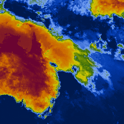
Wskaźnik suszy Keetch-Byram (KBDI) to ciągła skala referencyjna do szacowania suchości gleby i warstw ściółki. Indeks rośnie każdego dnia bez deszczu (wielkość wzrostu zależy od najwyższej temperatury w ciągu dnia) i maleje, gdy pada deszcz. Ten system opiera się głównie na ostatnich wzorcach opadów. Jest to miara suszy meteorologicznej, która odzwierciedla przyrost lub utratę wody w glebie.
Skala ma zakres od 0 (brak deficytu wilgoci) do 800 (ekstremalna susza). Zakres indeksu jest określany na podstawie założenia, że w nasyconej glebie znajduje się 20 cm wilgoci, która jest łatwo dostępna dla roślinności (Keetch i Byram, 1968). KBDI jest powszechnie stosowany na całym świecie do monitorowania suszy na potrzeby krajowych prognoz pogody, zapobiegania pożarom i jest szczególnie przydatny w regionach, w których uprawy są zależne od opadów deszczu.
Pasma
Rozmiar piksela
4000 metrów
Pasma
| Nazwa | Minimum | Maks. | Rozmiar piksela | Opis |
|---|---|---|---|---|
KBDI |
0 | 800 | metry | Wskaźnik suszy Keetch-Byram |
Warunki korzystania z usługi
Warunki usługi
Cytaty
Wataru Takeuchi, Soni Darmawan, Rizatus Shofiyati, Mai Van Khiem, Kyaw San Oo, Uday Pimple and Suthy Heng, 2015. System monitorowania suszy meteorologicznej i wczesnego ostrzegania w czasie zbliżonym do rzeczywistego na potrzeby obszarów uprawnych w Azji. 36th Asian conference on remote sensing (ACRS): Manila, Philippines, Oct. 20, 2015.
Odkrywaj za pomocą Earth Engine
Edytor kodu (JavaScript)
var collection = ee.ImageCollection('UTOKYO/WTLAB/KBDI/v1')
  .select('KBDI')
  .filterDate('2019-01-01', '2019-01-10');
var bandViz = {
  min: 0,
  max: 800,
  palette: [
    '001a4d', '003cb3', '80aaff', '336600', 'cccc00', 'cc9900', 'cc6600',
    '660033'
  ]
};
Map.addLayer(collection.mean(), bandViz, 'Keetch-Byram Drought Index');
Map.setCenter(120, 3, 3);