- Disponibilidade do conjunto de dados
- 2023-09-14T00:00:00Z–2023-09-14T00:00:00Z
- Produtor de conjunto de dados
- geoLab de William e Mary
- Tags
Descrição
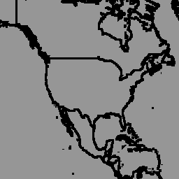
O banco de dados global de limites geográficos de limites administrativos políticos é um recurso on-line de licença aberta de limites (por exemplo, estado, condado) para todos os países do mundo. Atualmente, 199 entidades são rastreadas, incluindo todos os 195 estados-membros da ONU, Groenlândia, Taiwan, Niue e Kosovo.
As Zonas Administrativas Globais Abrangentes (CGAZ, na sigla em inglês) são um conjunto de composições globais para limites administrativos. As áreas em disputa são removidas e substituídas por polígonos de acordo com as definições do Departamento de Estado dos EUA. Ele tem três níveis de limite (ADM0, ADM1 e ADM2) cortados para limites internacionais (Departamento de Estado dos EUA), com lacunas preenchidas entre as fronteiras.
Esse conjunto de dados faz parte do CGAZ. Ele foi ingerido da versão 6.0.0 dos arquivos compostos globais com DBF_DATE_LAST_UPDATE=2023-09-13. Ele mostra limites no nível ADM0 (limites de país).
Esquema da tabela
Esquema da tabela
| Nome | Tipo | Descrição |
|---|---|---|
| shapeGroup | STRING | Código exclusivo do país |
| shapeName | STRING | Nome da região administrativa |
| shapeType | STRING | Tipo de limite:
|
Termos de Uso
Termos de Uso
Os conjuntos de dados geoBoundaries são fornecidos de acordo com a licença CC BY 4.0, que permite a maioria dos usos comerciais, não comerciais e acadêmicos. Consulte os termos de uso do provedor.
Explore com o Earth Engine
Editor de código (JavaScript)
var dataset = ee.FeatureCollection('WM/geoLab/geoBoundaries/600/ADM0');

Map.setCenter(-100.0, 38.5, 4);

var styleParams = {
  fillColor: 'b5ffb4',
  color: '00909F',
  width: 1.0,
};

dataset = dataset.style(styleParams);

Map.addLayer(dataset, {}, 'ADM0 Boundaries');