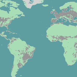
SBTN Natural Lands Map v1은 자연에 대한 과학 기반 목표를 설정하는 기업, 특히 SBTN 토지 목표 #1: 자연 생태계의 전환 없음이 사용하도록 설계된 2020년 자연 및 비자연 토지 피복 기준 지도입니다.
'자연' 및 '비자연' 정의는 책임 프레임워크 이니셔티브의 자연 생태계 정의에서 '종 구성, 구조, 생태학적 기능 측면에서 주요 인간 영향이 없는 특정 지역에서 발견되는 것과 실질적으로 유사한 것'으로 적용되었으며 관리 생태계와 자연적으로 또는 관리를 통해 재생될 것으로 예상되는 저하된 생태계를 포함할 수 있습니다 (AFi 2024). SBTN 자연 토지 지도는 가능한 한 AFi 안내에 부합하는 사용 가능한 데이터를 기반으로 프록시를 사용하여 이 정의를 운영합니다.
이 지도는 기존의 전역 및 지역 데이터를 컴파일하여 제작되었습니다.방법론을 설명하는 전체 기술 메모는 Natural Lands GitHub에서 확인할 수 있습니다.
이 연구는 세계자원연구소의 토지 및 탄소 연구소, 미국 세계자연기금, Systemiq, SBTN의 공동작업으로 진행되었습니다.
SBTN Natural Lands Map v1은 자연 및 비자연 토지 피복의 2020년 기준선 지도이며, 특히 SBTN 토지 목표 #1: 자연 생태계의 전환 없음과 같이 자연에 대한 과학 기반 목표를 설정하는 기업에서 사용하도록 설계되었습니다. '자연' 및 '비자연' 정의는 Accountability Framework 이니셔티브의 정의를 적용했습니다.
[null,null,[],[],[],null,["# SBTN Natural Lands Map v1\n\nDataset Availability\n: 2020-01-01T00:00:00Z--2020-12-31T23:59:59Z\n\nDataset Provider\n:\n\n\n [WRI](https://github.com/wri/natural-lands-map/tree/main)\n\nTags\n:\n[ecosystems](/earth-engine/datasets/tags/ecosystems) [landcover](/earth-engine/datasets/tags/landcover) [landuse-landcover](/earth-engine/datasets/tags/landuse-landcover) [wri](/earth-engine/datasets/tags/wri) \n\n#### Description\n\nThe SBTN Natural Lands Map v1 is a 2020 baseline map of natural and\nnon-natural land covers intended for use by companies setting\n[science-based targets for nature](https://sciencebasedtargetsnetwork.org/companies/take-action/),\nspecifically the SBTN Land target #1: no conversion of natural ecosystems.\n\n\"Natural\" and \"non-natural\" definitions were adapted from the\n[Accountability Framework initiative's definition of a natural\necosystem](https://accountability-framework.org/use-the-accountability-framework/definitions/natural-ecosystem/)\nas \"one that substantially resembles - in terms of species composition,\nstructure, and ecological function - what would be found in a given area\nin the absence of major human impacts\" and can include managed ecosystems\nas well as degraded ecosystems that are expected to regenerate either\nnaturally or through management (AFi 2024). The SBTN Natural Lands Map\noperationalizes this definition by using proxies based on available data\nthat align with AFi guidance to the extent possible.\n\nThis map was made by compiling existing global\nand regional data.You can find the full technical note explaining the\nmethodology linked on the\n[Natural Lands GitHub](https://github.com/wri/natural-lands-map).\nThis work was a collaboration between Land \\& Carbon Lab at the World\nResources Institute, World Wildlife Fund US, Systemiq, and SBTN.\n\n### Bands\n\n\n**Pixel Size**\n\n30 meters\n\n**Bands**\n\n| Name | Min | Max | Pixel Size | Description |\n|------------------|-----|-----|------------|----------------------------|\n| `classification` | 2 | 21 | meters | Land cover classification. |\n| `natural` | 0 | 1 | meters | Land cover classification. |\n\n**classification Class Table**\n\n| Value | Color | Description |\n|-------|---------|-----------------------------------|\n| 2 | #246E24 | natural forests |\n| 3 | #B9B91E | natural short vegetation |\n| 4 | #6BAED6 | natural water |\n| 5 | #06A285 | mangroves |\n| 6 | #FEFECC | bare |\n| 7 | #ACD1E8 | snow |\n| 8 | #589558 | wet natural forests |\n| 9 | #093D09 | natural peat forests |\n| 10 | #DBDB7B | wet natural short vegetation |\n| 11 | #99991A | natural peat short vegetation |\n| 12 | #D3D3D3 | crop |\n| 13 | #D3D3D3 | built |\n| 14 | #D3D3D3 | non-natural tree cover |\n| 15 | #D3D3D3 | non-natural short vegetation |\n| 16 | #D3D3D3 | non-natural water |\n| 17 | #D3D3D3 | wet non-natural tree cover |\n| 18 | #D3D3D3 | non-natural peat tree cover |\n| 19 | #D3D3D3 | wet non-natural short vegetation |\n| 20 | #D3D3D3 | non-natural peat short vegetation |\n| 21 | #D3D3D3 | non-natural bare |\n\n**natural Class Table**\n\n| Value | Color | Description |\n|-------|---------|------------------|\n| 0 | #969696 | Non-natural land |\n| 1 | #a8ddb5 | Natural land |\n\n### Terms of Use\n\n**Terms of Use**\n\n[CC-BY-NC-SA-4.0](https://spdx.org/licenses/CC-BY-NC-SA-4.0.html)\n\n### Citations\n\nCitations:\n\n- Mazur, E., M. Sims, E. Goldman, M. Schneider, M.D. Pirri, C.R. Beatty, F.\n Stolle, Stevenson, M. 2024. \"SBTN Natural Lands Map v1: Technical\n Documentation\". Science Based Targets for Land Version 1 - Supplementary\n Material. Science Based Targets Network.\n \u003chttps://sciencebasedtargetsnetwork.org/wp-content/uploads/2024/09/Technical-Guidance-2024-Step3-Land-v1-Natural-Lands-Map.pdf\u003e\n\n### Explore with Earth Engine\n\n| **Important:** Earth Engine is a platform for petabyte-scale scientific analysis and visualization of geospatial datasets, both for public benefit and for business and government users. Earth Engine is free to use for research, education, and nonprofit use. To get started, please [register for Earth Engine access.](https://console.cloud.google.com/earth-engine)\n\n### Code Editor (JavaScript)\n\n```javascript\nvar dataset = ee.Image('WRI/SBTN/naturalLands/v1/2020').select('natural');\n\nvar lon = 0;\nvar lat = 0;\n\nMap.setCenter(lon, lat, 2);\n\nMap.addLayer(dataset, {}, 'Natural Lands');\n```\n[Open in Code Editor](https://code.earthengine.google.com/?scriptPath=Examples:Datasets/WRI/WRI_SBTN_naturalLands_v1_2020) \n[SBTN Natural Lands Map v1](/earth-engine/datasets/catalog/WRI_SBTN_naturalLands_v1_2020) \nThe SBTN Natural Lands Map v1 is a 2020 baseline map of natural and non-natural land covers intended for use by companies setting science-based targets for nature, specifically the SBTN Land target #1: no conversion of natural ecosystems. \"Natural\" and \"non-natural\" definitions were adapted from the Accountability Framework initiative's definition ... \nWRI/SBTN/naturalLands/v1/2020, ecosystems,landcover,landuse-landcover,wri \n2020-01-01T00:00:00Z/2020-12-31T23:59:59Z \n-60 -180 75 180 \nGoogle Earth Engine \nhttps://developers.google.com/earth-engine/datasets\n\n- [](https://doi.org/https://github.com/wri/natural-lands-map/tree/main)\n- [](https://doi.org/https://developers.google.com/earth-engine/datasets/catalog/WRI_SBTN_naturalLands_v1_2020)"]]