- Dostępność zbioru danych
- 2000-02-11T00:00:00Z–2000-02-22T00:00:00Z
- Dostawca zbioru danych
- WWF
- Tagi
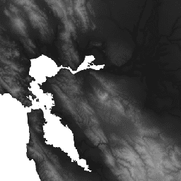
Opis
HydroSHEDS to produkt mapowy, który zawiera informacje hydrograficzne do zastosowań regionalnych i globalnych w spójnym formacie. Zawiera on zestaw zbiorów danych geograficznych (wektorowych i rastrowych) o różnej skali, w tym sieci rzeczne, granice działów wód, kierunki odpływu i akumulacje przepływu. HydroSHEDS opiera się na danych o wysokości uzyskanych w 2000 roku przez misję NASA Shuttle Radar Topography Mission (SRTM).
Ten zbiór danych wysokościowych uwzględniający warunki hydrologiczne jest wynikiem iteracyjnego procesu warunkowania i korekty. Pamiętaj, że proces kondycjonowania zmienia oryginalny DEM i może spowodować, że będzie on nieprawidłowy w przypadku zastosowań innych niż wyznaczanie kierunków spływu. Baseny endoreiczne (zagłębienia śródlądowe) są „zasiewane” komórką bez danych w najniższym punkcie, aby przerwać przepływ. Szczegółowe informacje o bazowym cyfrowym modelu terenu znajdziesz na stronie internetowej i w dokumentacji HydroSHEDS.
Ten zbiór danych ma rozdzielczość 3 sekund łuku. Zbiory danych dostępne w rozdzielczości 3 sekund łuku to DEM z wypełnionymi lukami, DEM z warunkami hydrologicznymi i kierunek odpływu (przepływu).
W pobliżu Vancouver w Kanadzie (50,16, -123,85) i Australii (-14,96, 129,62) występują 2 obszary z nieprawidłowymi wartościami ujemnymi –100.
Pasma
Pasma
Rozmiar piksela: 92,77 m (wszystkie pasma)
| Nazwa | Jednostki | Min. | Maks. | Rozmiar piksela | Opis |
|---|---|---|---|---|---|
b1 |
m | –440* | 8527* | 92,77 m | Wysokość |
Warunki korzystania z usługi
Warunki usługi
Dane HydroSHEDS są dostępne bezpłatnie do użytku niekomercyjnego i komercyjnego. Więcej informacji znajdziesz w umowie licencyjnej.
Cytaty
Lehner, B., Verdin, K., Jarvis, A. (2008): New global hydrography derived from spaceborne elevation data. Eos, Transactions, AGU, 89(10): 93-94.
Odkrywaj za pomocą Earth Engine
Edytor kodu (JavaScript)
var dataset = ee.Image('WWF/HydroSHEDS/03CONDEM');
var elevation = dataset.select('b1');
var elevationVis = {
  min: -50.0,
  max: 3000.0,
  gamma: 2.0,
};
Map.setCenter(-121.652, 38.022, 8);
Map.addLayer(elevation, elevationVis, 'Elevation');