- Disponibilidade do conjunto de dados
- 2000-02-11T00:00:00Z–2000-02-22T00:00:00Z
- Produtor de conjunto de dados
- WWF
- Tags
Descrição
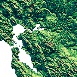
O HydroSHEDS é um produto de mapeamento que fornece informações hidrográficas para aplicativos regionais e globais em um formato consistente. Ele oferece um conjunto de dados georreferenciados (vetor e raster) em várias escalas, incluindo redes de rios, limites de bacias hidrográficas, direções de drenagem e acúmulos de fluxo. O HydroSHEDS é baseado em dados de elevação obtidos em 2000 pela Shuttle Radar Topography Mission (SRTM) da NASA.
Esse conjunto de dados define a direção do fluxo de cada célula no DEM condicionado para o vizinho de declive mais íngreme. Os valores da direção de drenagem variam de 1 a 128. Todas as células finais de saída para o oceano são sinalizadas com o valor 0. Todas as células que marcam o ponto mais baixo de uma bacia endorreica (depressão continental) são sinalizadas com o valor -1. Os valores de direção de drenagem seguem a convenção adotada pela implementação de direção de fluxo da ESRI: 1=E, 2=SE, 4=S, 8=SW, 16=W, 32=NW, 64=N, 128=NE.
Este conjunto de dados está na resolução de 3 segundos de arco.
Os conjuntos de dados disponíveis em 3 segundos de arco são o DEM preenchido com vazios, o DEM condicionado hidrologicamente e a direção de drenagem (fluxo).
A qualidade dos dados do HydroSHEDS é significativamente menor para regiões acima de 60 graus de latitude norte, já que não há dados de elevação do SRTM disponíveis. Por isso, foi usado um DEM de resolução mais baixa (HYDRO1k fornecido pelo USGS).
O HydroSHEDS foi desenvolvido pelo Programa de Ciência da Conservação do World Wildlife Fund (WWF) em parceria com o Serviço Geológico dos EUA, o Centro Internacional de Agricultura Tropical, a Nature Conservancy e o Centro de Pesquisa de Sistemas Ambientais da Universidade de Kassel, na Alemanha.
Bandas
Bandas
Tamanho do pixel: 92,77 metros (todas as bandas)
| Nome | Mín. | Máx. | Tamanho do pixel | Descrição |
|---|---|---|---|---|
b1 |
0* | 255* | 92,77 metros | Valores possíveis de direção de drenagem: 1=E, 2=SE, 4=S, 8=SW, 16=W, 32=NW, 64=N, 128=NE. As células de saída final para o oceano são sinalizadas com o valor 0, e as células que marcam o ponto mais baixo de uma bacia endorreica (depressão continental) são sinalizadas com o valor 255 (valor original de -1). |
Termos de Uso
Termos de Uso
Os dados do HydroSHEDS são sem custo financeiro para uso não comercial e comercial. Para mais informações, consulte o contrato de licença.
Citações
Lehner, B., Verdin, K., Jarvis, A. (2008): New global hydrography derived from spaceborne elevation data. Eos, Transactions, AGU, 89(10): 93-94.
Explore com o Earth Engine
Editor de código (JavaScript)
var dataset = ee.Image('WWF/HydroSHEDS/03DIR');
var drainageDirection = dataset.select('b1');
var drainageDirectionVis = {
  min: 1.0,
  max: 128.0,
  palette: [
    '000000', '023858', '006837', '1a9850', '66bd63', 'a6d96a', 'd9ef8b',
    'ffffbf', 'fee08b', 'fdae61', 'f46d43', 'd73027'
  ],
};
Map.setCenter(-121.652, 38.022, 8);
Map.addLayer(drainageDirection, drainageDirectionVis, 'Drainage Direction');