- ডেটাসেটের প্রাপ্যতা
- 2000-01-01T00:00:00Z–2021-01-01T00:00:00Z
- ডেটাসেট প্রযোজক
- ওয়ার্ল্ডপপ
- ট্যাগ
বর্ণনা
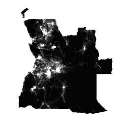
জনসংখ্যা বৃদ্ধির প্রভাব নির্ভুলভাবে পরিমাপ, পরিবর্তন পর্যবেক্ষণ এবং হস্তক্ষেপের পরিকল্পনা করার জন্য মানব জনসংখ্যা বণ্টনের বৈশ্বিক উচ্চ-রেজোলিউশন ও সমসাময়িক তথ্য একটি পূর্বশর্ত। ওয়ার্ল্ডপপ প্রকল্পের লক্ষ্য হলো স্বচ্ছ এবং পিয়ার-রিভিউড পদ্ধতি ব্যবহার করে তৈরি করা বিশদ ও উন্মুক্ত জনসংখ্যা বণ্টন ডেটাসেট প্রদানের মাধ্যমে এই চাহিদাগুলো পূরণ করা।
ডেটা তৈরিতে ব্যবহৃত পদ্ধতি ও ডেটাসেট সম্পর্কিত সম্পূর্ণ বিবরণ, উন্মুক্ত প্রকাশনাসহ, ওয়ার্ল্ডপপ ওয়েবসাইটে দেওয়া আছে। সংক্ষেপে, সাম্প্রতিক আদমশুমারি-ভিত্তিক জনসংখ্যার গণনাকে তাদের সংশ্লিষ্ট প্রশাসনিক ইউনিটের সাথে মিলিয়ে, মেশিন লার্নিং পদ্ধতির মাধ্যমে প্রায় ১০০x১০০ মিটার গ্রিড সেলে বিভক্ত করা হয়। এই পদ্ধতিটি জনসংখ্যার ঘনত্ব এবং বিভিন্ন ভূ-স্থানিক কোভেরিয়েট লেয়ারের মধ্যকার সম্পর্ককে কাজে লাগায়। ম্যাপিং পদ্ধতিটি হলো র্যান্ডম ফরেস্ট-ভিত্তিক ড্যাসিমেট্রিক পুনর্বণ্টন।
এই ডেটাসেটটি ২০১০, ২০১৫ এবং অন্যান্য বছরে প্রতিটি গ্রিড সেলে বসবাসকারী মানুষের আনুমানিক সংখ্যা তুলে ধরে।
২০২০ সালের জন্য, বয়স ও লিঙ্গ অনুযায়ী জনসংখ্যার বিভাজন WorldPop/GP/100m/pop_age_sex এবং WorldPop/GP/100m/pop_age_sex_cons_unadj কালেকশনগুলোতে পাওয়া যায়।
জনসংখ্যার বয়স কাঠামো, দারিদ্র্য, নগর বৃদ্ধি এবং জনসংখ্যা গতিবিদ্যা সম্পর্কিত আরও গ্রিডেড ডেটাসেট ওয়ার্ল্ডপপ ওয়েবসাইটে বিনামূল্যে পাওয়া যায়। ওয়ার্ল্ডপপ হলো ইউনিভার্সিটি অফ সাউদাম্পটন, ইউনিভার্সিটি লিবার ডি ব্রাসেলস এবং ইউনিভার্সিটি অফ লুইভিলের গবেষকদের মধ্যে একটি সহযোগিতা। এই প্রকল্পটি প্রধানত বিল অ্যান্ড মেলিন্ডা গেটস ফাউন্ডেশন দ্বারা অর্থায়ন করা হয়।
ব্যান্ড
ব্যান্ড
পিক্সেল সাইজ: ৯২.৭৭ মিটার (সকল ব্যান্ড)
| নাম | মিনিট | ম্যাক্স | পিক্সেল আকার | বর্ণনা |
|---|---|---|---|---|
population | ০* | ২১১৭১* | ৯২.৭৭ মিটার | প্রতিটি গ্রিড সেলে বসবাসকারী মানুষের আনুমানিক সংখ্যা |
ছবির বৈশিষ্ট্য
ছবির বৈশিষ্ট্য
| নাম | প্রকার | বর্ণনা |
|---|---|---|
| দেশ | স্ট্রিং | দেশ |
| বছর | ডাবল | বছর |
ব্যবহারের শর্তাবলী
ব্যবহারের শর্তাবলী
WorldPop ডেটাসেটগুলো ক্রিয়েটিভ কমন্স অ্যাট্রিবিউশন ৪.০ আন্তর্জাতিক লাইসেন্সের অধীনে লাইসেন্সপ্রাপ্ত। ব্যবহারকারীরা বাণিজ্যিক এবং অবাণিজ্যিক উদ্দেশ্যে কোনো বিধিনিষেধ ছাড়াই এই কাজটি ব্যবহার, অনুলিপি, বিতরণ, প্রেরণ এবং অভিযোজন করতে পারেন, যতক্ষণ পর্যন্ত উৎসের স্পষ্ট স্বীকৃতি প্রদান করা হয়।
উদ্ধৃতি
অনুগ্রহ করে উৎস হিসেবে ওয়ার্ল্ডপপ ওয়েবসাইট www.worldpop.org উল্লেখ করুন।
আমেরিকার জনসংখ্যা উপাত্ত: আলেসান্দ্রো সোরিচেত্তা, গ্রেম এম. হর্নবি, ফরেস্ট আর. স্টিভেন্স, আন্দ্রেয়া ই. গগান, ক্যাথরিন লিনার্ড, অ্যান্ড্রু জে. টেটেম, ২০১৫, ২০১০, ২০১৫ এবং ২০২০ সালের জন্য লাতিন আমেরিকা ও ক্যারিবিয়ান অঞ্চলের উচ্চ-রেজোলিউশন গ্রিডেড জনসংখ্যা ডেটাসেট, সায়েন্টিফিক ডেটা, doi:10.1038/sdata.2015.45
আফ্রিকার জনসংখ্যা গণনার তথ্য: লিনার্ড, সি., গিলবার্ট, এম., স্নো, আরডব্লিউ, নূর, এএম এবং টেটেম, এজে, ২০১২, ২০১০ সালে আফ্রিকা জুড়ে জনসংখ্যার বন্টন, বসতি বিন্যাস এবং প্রবেশগম্যতা, পিএলওএস ওয়ান, 7(2): e31743।
এশিয়ার জনসংখ্যা গণনার তথ্য: Gaughan AE, Stevens FR, Linard C, Jia P and Tatem AJ, 2013, High resolution population distribution maps for Southeast Asia in 2010 and 2015, PLoS ONE, 8(2): e55882.
DOI
আর্থ ইঞ্জিন দিয়ে অন্বেষণ করুন
কোড এডিটর (জাভাস্ক্রিপ্ট)
var dataset = ee.ImageCollection('WorldPop/GP/100m/pop');

var visualization = {
  bands: ['population'],
  min: 0.0,
  max: 50.0,
  palette: ['24126c', '1fff4f', 'd4ff50']
};

Map.setCenter(113.643, 34.769, 7);

Map.addLayer(dataset, visualization, 'Population');
import ee
import geemap.core as geemap
কোলাব (পাইথন)
dataset = ee.ImageCollection('WorldPop/GP/100m/pop')

visualization = {
    'bands': ['population'],
    'min': 0.0,
    'max': 50.0,
    'palette': ['24126c', '1fff4f', 'd4ff50'],
}

m = geemap.Map()
m.set_center(113.643, 34.769, 7)
m.add_layer(dataset, visualization, 'Population')
m