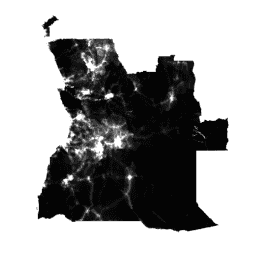
Globalne dane o rozmieszczeniu ludności o wysokiej rozdzielczości i aktualności są niezbędne do dokładnego pomiaru wpływu wzrostu populacji, monitorowania zmian i planowania interwencji. Projekt WorldPop ma na celu zaspokojenie tych potrzeb poprzez udostępnianie szczegółowych i otwartych zbiorów danych o rozmieszczeniu ludności, które są tworzone przy użyciu przejrzystych i recenzowanych metod.
Szczegółowe informacje o metodach i zbiorach danych użytych do tworzenia danych oraz publikacje z otwartym dostępem znajdziesz na stronie WorldPop. W skrócie: ostatnie dane o liczbie ludności pochodzące ze spisu powszechnego, dopasowane do powiązanych z nimi jednostek administracyjnych, są rozdzielane na komórki siatki o wymiarach ok. 100 x 100 m za pomocą metod uczenia maszynowego, które wykorzystują relacje między gęstością zaludnienia a zakresem warstw zmiennych przestrzennych. Metoda mapowania
to dasymetryczna redystrybucja oparta na lesie losowym.
Ten zbiór danych przedstawia szacunkową liczbę osób mieszkających w każdej komórce siatki w 2010 r., 2015 r. i innych latach.
Dalsze zbiory danych siatkowych WorldPop dotyczące struktur wiekowych populacji, ubóstwa, rozwoju miast i dynamiki populacji są dostępne bezpłatnie na stronie internetowej WorldPop. WorldPop to projekt, w którym uczestniczą badacze z University of Southampton, Universite Libre de Bruxelles i University of Louisville. Projekt jest finansowany głównie przez Fundację Billa i Melindy Gatesów.
Pasma
Rozmiar piksela 92,77 m
Pasma
Nazwa
Minimum
Maks.
Rozmiar piksela
Opis
population
0*
21171*
metry
Szacunkowa liczba osób mieszkających w każdej komórce siatki
* szacowana wartość minimalna lub maksymalna
Właściwości obrazu
Właściwości obrazu
Nazwa
Typ
Opis
kraj
CIĄG ZNAKÓW
Kraj
rok
LICZBA ZMIENNOPRZECINKOWA O PODWÓJNEJ PRECYZJI
Rok
Warunki korzystania z usługi
Zbiory danych WorldPop są objęte międzynarodową licencją Creative Commons Attribution 4.0. Użytkownicy mogą bez ograniczeń używać, kopiować, rozpowszechniać, przesyłać i adaptować utwór do celów komercyjnych i niekomercyjnych, pod warunkiem że podane zostanie wyraźne oznaczenie źródła.
Dane o populacji Ameryk: Alessandro Sorichetta, Graeme M. Hornby,
Forrest R. Stevens, Andrea E. Gaughan, Catherine Linard, Andrew J. Tatem,
2015, High-resolution gridded population datasets for Latin America and the
Caribbean in 2010, 2015, and 2020, Scientific Data,
doi:10.1038/sdata.2015.45
Dane dotyczące liczby ludności w Afryce: Linard, C., Gilbert, M., Snow, R.W., Noor, A.M. i Tatem, A.J., 2012, Population distribution, settlement patterns
and accessibility across Africa in 2010, PLoS ONE, 7(2): e31743.
Dane o liczbie ludności w Azji: Gaughan AE, Stevens FR, Linard C, Jia P i Tatem AJ, 2013, High resolution population distribution maps for Southeast Asia in 2010 and 2015, PLoS ONE, 8(2): e55882.
Globalne dane o wysokiej rozdzielczości dotyczące rozmieszczenia ludności są niezbędne do dokładnego pomiaru wpływu wzrostu populacji, monitorowania zmian i planowania interwencji. Projekt WorldPop ma na celu zaspokojenie tych potrzeb poprzez udostępnianie szczegółowych i otwartych zbiorów danych o rozmieszczeniu ludności, które są tworzone przy użyciu przejrzystych…
[null,null,[],[[["\u003cp\u003eThe WorldPop dataset provides global, high-resolution population distribution data from 2000 to 2021.\u003c/p\u003e\n"],["\u003cp\u003eIt uses Random Forest-based dasymetric redistribution to estimate the number of people residing in each 100x100m grid cell.\u003c/p\u003e\n"],["\u003cp\u003eData is available for various years, with a breakdown of population by age and sex offered for 2020 in related datasets.\u003c/p\u003e\n"],["\u003cp\u003eWorldPop data is freely available under the Creative Commons Attribution 4.0 International License and requires attribution when used.\u003c/p\u003e\n"],["\u003cp\u003eThe project is a collaborative effort funded by the Bill and Melinda Gates Foundation, aiming to support research and interventions related to population dynamics.\u003c/p\u003e\n"]]],[],null,["# WorldPop Global Project Population Data: Estimated Residential Population per 100x100m Grid Square\n\nDataset Availability\n: 2000-01-01T00:00:00Z--2021-01-01T00:00:00Z\n\nDataset Provider\n:\n\n\n [WorldPop](https://www.worldpop.org)\n\nTags\n:\n[demography](/earth-engine/datasets/tags/demography) [population](/earth-engine/datasets/tags/population) [worldpop](/earth-engine/datasets/tags/worldpop) \n\n#### Description\n\nGlobal high-resolution, contemporary data on human population distributions are\na prerequisite for the accurate measurement of the impacts of population\ngrowth, for monitoring changes, and for planning interventions. The WorldPop\nproject aims to meet these needs through the provision of detailed and open\naccess population distribution datasets built using transparent and\npeer-reviewed approaches.\n\nFull details on the methods and datasets used in constructing the\ndata, along with open access publications, are provided on the\n[WorldPop website](https://www.worldpop.org/). In brief, recent census-based\npopulation counts matched to their associated administrative units are\ndisaggregated to \\~100x100m grid cells through machine learning approaches\nthat exploit the relationships between population densities and a range of\ngeospatial covariate layers. The mapping approach\nis Random Forest-based dasymetric redistribution.\n\nThis dataset depict estimated number of people\nresiding in each grid cell in 2010, 2015, and other years.\n\nFor 2020, the breakdown of population by age and sex is available in\nthe [WorldPop/GP/100m/pop_age_sex](/earth-engine/datasets/catalog/WorldPop_GP_100m_pop_age_sex)\nand [WorldPop/GP/100m/pop_age_sex_cons_unadj](/earth-engine/datasets/catalog/WorldPop_GP_100m_pop_age_sex_cons_unadj)\ncollections.\n\nFurther WorldPop gridded datasets on population age structures,\npoverty, urban growth, and population dynamics are freely available on\nthe WorldPop website. WorldPop represents a collaboration between\nresearchers at the University of Southampton, Universite Libre de\nBruxelles, and University of Louisville. The project is principally funded by\nthe Bill and Melinda Gates Foundation.\n\n### Bands\n\n\n**Pixel Size**\n\n92.77 meters\n\n**Bands**\n\n| Name | Min | Max | Pixel Size | Description |\n|--------------|-----|---------|------------|-------------------------------------------------------|\n| `population` | 0\\* | 21171\\* | meters | Estimated number of people residing in each grid cell |\n\n\\* estimated min or max value\n\n### Image Properties\n\n**Image Properties**\n\n| Name | Type | Description |\n|---------|--------|-------------|\n| country | STRING | Country |\n| year | DOUBLE | Year |\n\n### Terms of Use\n\n**Terms of Use**\n\nWorldPop datasets are licensed under the Creative Commons Attribution 4.0\nInternational License. Users are free to use, copy, distribute, transmit,\nand adapt the work for commercial and non-commercial purposes, without\nrestriction, as long as clear attribution of the source is provided.\n\n### Citations\n\nCitations:\n\n- Please cite the WorldPop website as the source: [www.worldpop.org](https://www.worldpop.org).\n- Americas population data: Alessandro Sorichetta, Graeme M. Hornby,\n Forrest R. Stevens, Andrea E. Gaughan, Catherine Linard, Andrew J. Tatem,\n 2015, High-resolution gridded population datasets for Latin America and the\n Caribbean in 2010, 2015, and 2020, Scientific Data,\n [doi:10.1038/sdata.2015.45](https://doi.org/10.1038/sdata.2015.45)\n- Africa population count data: Linard, C., Gilbert, M., Snow, R.W., Noor,\n A.M. and Tatem, A.J., 2012, Population distribution, settlement patterns\n and accessibility across Africa in 2010, PLoS ONE, 7(2): e31743.\n- Asia population count data: Gaughan AE, Stevens FR, Linard C, Jia P and\n Tatem AJ, 2013, High resolution population distribution maps for Southeast\n Asia in 2010 and 2015, PLoS ONE, 8(2): e55882.\n\n### DOIs\n\n- \u003chttps://doi.org/10.1038/sdata.2015.45\u003e\n\n### Explore with Earth Engine\n\n| **Important:** Earth Engine is a platform for petabyte-scale scientific analysis and visualization of geospatial datasets, both for public benefit and for business and government users. Earth Engine is free to use for research, education, and nonprofit use. To get started, please [register for Earth Engine access.](https://console.cloud.google.com/earth-engine)\n\n### Code Editor (JavaScript)\n\n```javascript\nvar dataset = ee.ImageCollection('WorldPop/GP/100m/pop');\n\nvar visualization = {\n bands: ['population'],\n min: 0.0,\n max: 50.0,\n palette: ['24126c', '1fff4f', 'd4ff50']\n};\n\nMap.setCenter(113.643, 34.769, 7);\n\nMap.addLayer(dataset, visualization, 'Population');\n```\n[Open in Code Editor](https://code.earthengine.google.com/?scriptPath=Examples:Datasets/WorldPop/WorldPop_GP_100m_pop) \n[WorldPop Global Project Population Data: Estimated Residential Population per 100x100m Grid Square](/earth-engine/datasets/catalog/WorldPop_GP_100m_pop) \nGlobal high-resolution, contemporary data on human population distributions are a prerequisite for the accurate measurement of the impacts of population growth, for monitoring changes, and for planning interventions. The WorldPop project aims to meet these needs through the provision of detailed and open access population distribution datasets built using transparent ... \nWorldPop/GP/100m/pop, demography,population,worldpop \n2000-01-01T00:00:00Z/2021-01-01T00:00:00Z \n-90 -180 90 180 \nGoogle Earth Engine \nhttps://developers.google.com/earth-engine/datasets\n\n- [https://doi.org/10.1038/sdata.2015.45](https://doi.org/https://www.worldpop.org)\n- [https://doi.org/10.1038/sdata.2015.45](https://doi.org/https://developers.google.com/earth-engine/datasets/catalog/WorldPop_GP_100m_pop)"]]