- Pemilik Katalog
- Global Pasture Watch
- Ketersediaan Set Data
- 2000-01-01T00:00:00Z–2024-01-01T00:00:00Z
- Penyedia Set Data
- Land and Carbon Lab Global Pasture Watch
- Kontak
- Land & Carbon Lab
- Rangkaian Langkah Penjualan
- 1 Tahun
- Tag
Deskripsi
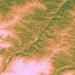
Set data ini menyediakan Produktivitas Primer Kotor (GPP) berbasis EO global yang tidak dikalibrasi sejak tahun 2000 pada resolusi spasial 30 m. Set data saat ini, yang dihasilkan oleh inisiatif Land & Carbon Lab Global Pasture Watch, memberikan nilai Produktivitas Primer Kotor (GPP) secara global pada resolusi spasial 30 m mulai tahun 2000 dan seterusnya. Nilai GPP dimodelkan melalui pendekatan efisiensi penggunaan cahaya (LUE), dengan GLAD Landsat ARD (collection-2) digabungkan setiap dua bulan (Consoli et al., 2024) dan digabungkan dengan data suhu MODIS 1 km dan Radiasi Aktif Fotosintetik CERES (PAR) 1°.
Untuk menjaga fleksibilitas set data, efisiensi penggunaan cahaya maksimum (LUEmax) ditetapkan ke 1 gC/m²/hari/MJ untuk semua jenis tutupan lahan, sehingga pengguna dapat mengalibrasi nilai GPP nanti sesuai dengan peta tutupan lahan atau kondisi regional tertentu.
Nilai Produktivitas Primer Bruto (GPP) yang tidak dikalibrasi dua bulanan (tersedia di STAC OpenLandMap) dirata-ratakan setiap tahun dan diakumulasikan selama periode 365 hari penuh untuk menghasilkan nilai uGPP tahunan global, yang dinyatakan dalam satuan gC/m²/tahun.
Nilai GPP Padang Rumput dihitung secara langsung menggunakan Aplikasi GEE.
Batasan:
Ketidakcocokan resolusi data input: Set data disediakan pada resolusi 30 m, tetapi variabel input utama untuk suhu (MOD11A1) dan radiasi aktif fotosintetik (CERES PAR) berasal dari produk yang jauh lebih kasar (1 km dan ~111 km). Pengecilan skala informasi ini dapat menimbulkan ketidakpastian dan mungkin tidak mencakup kondisi iklim mikro skala kecil yang memengaruhi produktivitas tanaman.
Artefak data: Set data berisi artefak visual yang diketahui, termasuk garis vertikal ("efek garis") di beberapa area, yang merupakan akibat dari masalah pada sensor Landsat 7 (kegagalan Scan Line Corrector) dan proses pengisian kesenjangan berikutnya yang digunakan untuk membuat arsip reflektansi yang mendasarinya (Consoli et al., 2024). Artefak ini dapat mengganggu kontinuitas spasial perkiraan GPP selama periode berawan dan tertutup salju
Resolusi temporal: Data dihasilkan pada resolusi temporal dua bulanan. Jangka waktu ini mungkin tidak cukup untuk mencatat periode pertumbuhan utama atau respons cepat tanaman (curah hujan tinggi) terhadap perubahan lingkungan, sehingga sulit untuk mencatat puncak produktivitas dan variasi musiman secara akurat.
Kalibrasi padang rumput: Nilai GPP padang rumput dihitung menggunakan satu parameter efisiensi penggunaan cahaya maksimum (LUEmax) (0,86 gC/m²/tahun/MJ) untuk semua padang rumput global, berdasarkan algoritma MOD17. Nilai ini tidak dioptimalkan untuk jenis padang rumput tertentu atau kondisi lokal. Akibatnya, model menunjukkan kecenderungan untuk meremehkan GPP jika dibandingkan dengan pengukuran menara fluks berbasis darat.
Ketergantungan pada akurasi peta padang rumput: Akurasi nilai GPP padang rumput bergantung pada akurasi peta padang rumput GPW yang mendasarinya. Setiap kesalahan klasifikasi tutupan lahan dalam peta sumber (misalnya, semak belukar atau lahan pertanian yang diidentifikasi sebagai padang rumput) akan menyebabkan kesalahan yang sesuai dalam perkiraan GPP untuk lokasi tersebut.
Untuk mengetahui informasi selengkapnya, lihat Isik et al., 2025, Zenodo, dan situs GitHub Global Pasture Watch
Band
Band
| Nama | Min | Maks | Ukuran Piksel | Deskripsi |
|---|---|---|---|---|
gc_m2 |
0 | 4000 | 30 meter | Gram karbon per meter persegi per tahun (gC/m²/tahun) |
Properti Gambar
Properti Gambar
| Nama | Jenis | Deskripsi |
|---|---|---|
| versi | INT | Versi produk |
Persyaratan Penggunaan
Persyaratan Penggunaan
Kutipan
Isik, M. S., Mesquita, V., Parente, L., & Consoli, D. (2025). Global Pasture Watch - Kode Sumber GPP berbasis EO Global yang Tidak Dikalibrasi dan Peta GPP Padang Rumput Global pada 30 m. Zenodo. [Kode sumber]. Zenodo doi:https://doi.org/10.5281/zenodo.15675358
Isik MS, Parente L, Consoli D, et al. (2025). Efisiensi penggunaan cahaya (LUE) berdasarkan produktivitas primer kotor (GPP) dua bulanan untuk padang rumput global pada resolusi spasial 30 m (2000–2022), PeerJ. doi: https://doi.org/10.7717/peerj.19774
DOI
Mengeksplorasi dengan Earth Engine
Editor Kode (JavaScript)
Map.setCenter(-49.265188, -16.602052, 4);

var ugppVis = {min: 0, max: 4000, palette: "faccfa,f19d6b,828232,226061,011959"}
var ugpp = ee.ImageCollection(
    "projects/global-pasture-watch/assets/ggpp-30m/v1/ugpp_m"
)

var ugpp2024 = ugpp.filterDate('2024-01-01', '2025-01-01').first();
Map.addLayer(ugpp2024, ugppVis, 'Uncalibrated GPP (2024)');

var ugpp2000 = ugpp.filterDate('2000-01-01', '2001-01-01').first();
Map.addLayer(ugpp2000, ugppVis, 'Uncalibrated GPP (2000)');