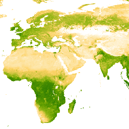
Bu Gelişmiş Bitki Örtüsü İndeksi (EVI) ürününün temel veri kümesi, Weiss ve diğerleri (2014) tarafından belirtilen yaklaşım kullanılarak boşluk doldurma işlemi yapılmış MODIS BRDF düzeltilmiş görüntüleri (MCD43B4) olup bulut örtüsü gibi faktörlerden kaynaklanan eksik verileri ortadan kaldırır. Veriler, boşluk doldurma işleminden sonra geçerli değerler sağlamak için [0, 1] eşiklerine göre kırpıldı.
Boşlukları doldurulmuş 8 günlük ~1 km çıkışlar daha sonra aylık ve yıllık ürünler oluşturmak için zamansal olarak toplanır.
Bantlar
Piksel Boyutu 5.000 metre
Bantlar
Ad
Min.
Maks.
Piksel Boyutu
Açıklama
Mean
0*
1*
metre
Her birleştirilmiş piksel için gelişmiş bitki örtüsü indeksinin ortalama değeri.
Weiss, D.J., P.M. Atkinson, S. Bhatt, B. Mappin, S.I. Hay & P.W. Gething
(2014) An effective approach for gap-filling continental scale remotely
sensed time-series. ISPRS Journal of Photogrammetry and Remote Sensing,
98, 106-118.
doi:10.1016/j.isprsjprs.2014.10.001
Bu Gelişmiş Bitki Örtüsü İndeksi (EVI) ürününün temel veri kümesi, bulut örtüsü gibi faktörlerden kaynaklanan eksik verileri ortadan kaldırmak için Weiss ve diğerleri (2014) tarafından belirtilen yaklaşımla boşluk doldurma işlemi uygulanan MODIS BRDF düzeltilmiş görüntüleridir (MCD43B4). Boşluk doldurma işleminden sonra veriler [0, 1] eşiklerine kırpılarak …
[null,null,[],[],[],null,["info\n\n\nThis dataset is part of a Publisher Catalog, and not managed by Google Earth Engine.\n\nContact [The Malaria Atlas Project](/earth-engine/datasets/catalog/data.malariaatlas.org@thekids.org.au)\n\nfor bugs or [view more datasets](https://developers.google.com/earth-engine/datasets/publisher/malariaatlasproject)\nfrom the The Malaria Atlas Project Catalog. [Learn more about Publisher datasets](/earth-engine/datasets/publisher). \n[](https://data.malariaatlas.org) \n\nCatalog Owner\n: The Malaria Atlas Project\n\nDataset Availability\n: 2001-02-01T00:00:00Z--2024-12-26T00:00:00Z\n\nDataset Provider\n:\n\n\n [The Malaria Atlas Project](https://www.malariaatlas.org)\n\nContact\n: [The Malaria Atlas Project](/earth-engine/datasets/catalog/data.malariaatlas.org@thekids.org.au)\n\nCadence\n: 8 Days\n\nTags\n:\n[evi](/earth-engine/datasets/tags/evi) [malariaatlasproject](/earth-engine/datasets/tags/malariaatlasproject) [map](/earth-engine/datasets/tags/map) [publisher-dataset](/earth-engine/datasets/tags/publisher-dataset) [vegetation](/earth-engine/datasets/tags/vegetation) [vegetation-indices](/earth-engine/datasets/tags/vegetation-indices) \n\nDescription \nThe underlying dataset for this Enhanced Vegetation Index (EVI)\nproduct is MODIS BRDF-corrected imagery (MCD43B4), which was gap-filled\nusing the approach outlined in Weiss et al. (2014) to eliminate missing\ndata caused by factors such as cloud cover. After gap-filling the data was clipped to thresholds of \\[0, 1\\] to ensure valid values.\n\nThe gap-filled 8-daily \\~1km outputs are then aggregated temporally to produce monthly and annual products.\n\nBands\n\n\n**Pixel Size**\n\n5000 meters\n\n**Bands**\n\n| Name | Min | Max | Pixel Size | Description |\n|--------|-----|-----|------------|----------------------------------------------------------------------------|\n| `Mean` | 0\\* | 1\\* | meters | The mean value of the Enhanced Vegetation Index for each aggregated pixel. |\n\n\\* estimated min or max value\n\nTerms of Use\n\n**Terms of Use**\n\n[CC-BY-NC-SA-4.0](https://spdx.org/licenses/CC-BY-NC-SA-4.0.html)\n\nCitations \nCitations:\n\n- Weiss, D.J., P.M. Atkinson, S. Bhatt, B. Mappin, S.I. Hay \\& P.W. Gething\n (2014) An effective approach for gap-filling continental scale remotely\n sensed time-series. ISPRS Journal of Photogrammetry and Remote Sensing,\n 98, 106-118.\n [doi:10.1016/j.isprsjprs.2014.10.001](https://doi.org/10.1016/j.isprsjprs.2014.10.001)\n\nExplore with Earth Engine **Important:** Earth Engine is a platform for petabyte-scale scientific analysis and visualization of geospatial datasets, both for public benefit and for business and government users. Earth Engine is free to use for research, education, and nonprofit use. To get started, please [register for Earth Engine access.](https://console.cloud.google.com/earth-engine)\n\nCode Editor (JavaScript) \n\n```javascript\nvar dataset = ee.ImageCollection('projects/malariaatlasproject/assets/EVI_v061/1km/8-Daily')\n .filter(ee.Filter.date('2022-01-01', '2022-04-01'));\nvar means = dataset.select('Mean');\nvar visParams = {\n min: 0.0,\n max: 1.0,\n palette: ['ffffff','fcd163','99b718','66a000','3e8601','207401','056201','004c00','011301'],\n};\nMap.setCenter(0, 0, 2);\nMap.addLayer(means, visParams, '8-Daily EVI: Malaria Atlas Project Gap-Filled Enhanced Vegetation Index');\n```\n[Open in Code Editor](https://code.earthengine.google.com/?scriptPath=Examples:Datasets/malariaatlasproject/projects_malariaatlasproject_assets_EVI_v061_1km_8-Daily) \n[EVI: Malaria Atlas Project Gap-Filled Enhanced Vegetation Index (8-Daily 1km)](/earth-engine/datasets/catalog/projects_malariaatlasproject_assets_EVI_v061_1km_8-Daily) \nThe underlying dataset for this Enhanced Vegetation Index (EVI) product is MODIS BRDF-corrected imagery (MCD43B4), which was gap-filled using the approach outlined in Weiss et al. (2014) to eliminate missing data caused by factors such as cloud cover. After gap-filling the data was clipped to thresholds of \\[0, 1\\] to ... \nprojects/malariaatlasproject/assets/EVI_v061/1km/8-Daily, evi,malariaatlasproject,map,publisher-dataset,vegetation,vegetation-indices \n2001-02-01T00:00:00Z/2024-12-26T00:00:00Z \n-90 -180 90 180 \nGoogle Earth Engine \nhttps://developers.google.com/earth-engine/datasets\n\n- [](https://doi.org/https://www.malariaatlas.org)\n- [](https://doi.org/https://developers.google.com/earth-engine/datasets/catalog/projects_malariaatlasproject_assets_EVI_v061_1km_8-Daily)"]]