- Katalog Sahibi
- Nature Trace
- Veri Kümesi Kullanılabilirliği
- 2018-01-01T00:00:00Z–2020-12-31T23:59:59Z
- Veri Kümesi Sağlayıcı
- Etiketler
Açıklama
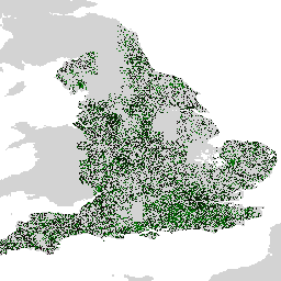
Farmscapes 2020 veri kümesi, İngiltere'nin tarım arazilerindeki üç temel yarı doğal özellik için yüksek çözünürlüklü (25 cm) olasılık haritaları sağlar: çitler, ormanlık alanlar ve taş duvarlar. Bu veri seti, peyzaj restorasyonu, biyolojik çeşitlilik izleme ve ekolojik bağlantı analizi gibi uygulamalarda temel olarak kullanılmak üzere Oxford Leverhulme Centre for Nature Recovery ile işbirliği içinde geliştirilmiştir.
Veri kümesi, yüksek çözünürlüklü havadan çekilmiş görüntülerden oluşan bir mozaik üzerinde, insan tarafından açıklama eklenmiş büyük bir etiket derlemesi kullanılarak eğitilmiş bir Vision Transformer modeli uygulanarak oluşturulmuştur. Çıkış, her özellik sınıfı için bir tane olmak üzere üç farklı olasılık katmanından oluşur. Bu olasılıksal biçim, kullanıcıların belirli analiz gereksinimlerine göre uyarlanmış ikili özellik haritaları oluşturmak için özel eşikler uygulamasına olanak tanır.
Sınırlamalar
- Coğrafi Kapsam: Model performansı, öncelikli olarak kırsal manzaralara odaklanan eğitim verilerinde yeterince temsil edilmeyen yoğun kentsel ortamlarda ve dağlık bölgelerde düşer.
- Zamansal Doğruluk: Kaynak görüntüler 2018 ile 2020 arasında çekilmiştir. Dolayısıyla, veri kümesi bu dönemden beri meydana gelen arazi değişikliklerini hesaba katmaz.
- Sınıfa özgü performans: Taş duvar sınıfı, eğitim verilerindeki önemli sınıf dengesizliği nedeniyle orman ve çitlere kıyasla daha düşük doğruluk gösteriyor.
Avrupa Veri Kümesi
İngiltere'ye ait birincil veri kümesine ek olarak, Avrupa ölçeğinde bir ön sürüm oluşturuldu. Bu veri kümesi aynı nicel doğrulamaya tabi tutulmamıştır ve deneysel olarak kabul edilmelidir. Bu formu göndererek bu veri kümesine erişim isteğinde bulunabilirsiniz.
Bantlar
Piksel Boyutu
0,25 metre
Bantlar
| Ad | Min. | Maks. | Ölçek | Piksel Boyutu | Açıklama |
|---|---|---|---|---|---|
B0 |
0 | 250 | 0,004 | metre | Çit olasılığı ([0-250] aralığında ölçeklenir). |
B1 |
0 | 250 | 0,004 | metre | Taş duvar olasılığı (0-250 aralığında ölçeklenir). |
B2 |
0 | 250 | 0,004 | metre | Orman/ağaç olasılığı (0-250 aralığında ölçeklenir). |
Kullanım Şartları
Kullanım Şartları
Bu veri kümesi CC-BY 4.0 kapsamında lisanslanmıştır ve şu ilişkilendirme gereklidir: "Bu veri kümesi Google tarafından üretilmiştir."
Alıntılar
Michelangelo Conserva, Alex Wilson, Charlotte Stanton, Vishal Batchu, Varun Gulshan , "Mapping Farmed Landscapes from Remote Sensing" (İnceleme aşamasında). doi:10.48550/arXiv.2506.13993,
Earth Engine ile keşfetme
Kod Düzenleyici (JavaScript)
var farmscapes =
    ee.ImageCollection('projects/nature-trace/assets/farmscapes/england_v1_0')
        .mosaic();
Map.addLayer(farmscapes, {}, 'Raw probs', false);

var stone_wall = farmscapes.select(['B1']);
stone_wall = stone_wall.updateMask(stone_wall.gt(250 / 4));
Map.addLayer(
    stone_wall, {palette: ['FFFFFF', '00FFFF'], min: 0, max: 250},
    'Stone wall');

var hedgerow = farmscapes.select(['B0']);
hedgerow = hedgerow.updateMask(hedgerow.gt(250 / 4));
Map.addLayer(
    hedgerow, {palette: ['FFFFFF', 'c71585'], min: 0, max: 250}, 'Hedgerow');

var woodland = farmscapes.select(['B2']);
woodland = woodland.updateMask(woodland.gt(250 / 4));
Map.addLayer(
    woodland, {palette: ['FFFFFF', '06402B'], min: 0, max: 250}, 'Woodland');

var lon = -1.43;
var lat = 52.973;
Map.setCenter(lon, lat, 15);