- Владелец каталога
- Потрясающий каталог сообщества GEE
- Доступность набора данных
- 2000-01-01T00:00:00Z–2023-12-31T00:00:00Z
- Поставщик наборов данных
- Национальная лаборатория Оук-Ридж
- Теги
Описание
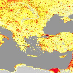
Набор данных LandScan, предоставленный Ок-Риджской национальной лабораторией (ORNL), представляет собой комплексную и высокоточную информацию о распределении населения по всему миру, которая служит ценным ресурсом для широкого спектра приложений. Используя передовые методы пространственного моделирования и передовые источники геопространственных данных, LandScan предоставляет подробную информацию о численности и плотности населения с разрешением 30 угловых секунд, что позволяет получать точные и актуальные данные о характере расселения людей по всему миру. Благодаря своей точности и детализации LandScan подходит для различных областей, таких как городское планирование, ликвидация последствий стихийных бедствий, эпидемиология и экологические исследования, что делает его незаменимым инструментом для лиц, принимающих решения, и исследователей, стремящихся понять и решить различные социальные и экологические проблемы в глобальном масштабе.
Группы
Размер пикселя
1000 метров
Группы
| Имя | Мин. | Макс | Размер пикселя | Описание |
|---|---|---|---|---|
b1 | 0* | 21171* | метров | Предполагаемая численность населения |
Условия эксплуатации
Условия эксплуатации
Наборы данных Landscan лицензированы по лицензии Creative Commons Attribution 4.0 International. Пользователи могут использовать, копировать, распространять, передавать и адаптировать работу в коммерческих и некоммерческих целях без ограничений при условии чёткого указания источника.
Цитаты
Симс, К., Рейт, А., Брайт, Э., Кауфман, Дж., Пайл, Дж., Эптинг, Дж., Гонсалес, Дж., Адамс, Д., Пауэлл, Э., Урбан, М. и Роуз, А. (2023). LandScan Global 2022 [Набор данных]. Национальная лаборатория Оук-Ридж. https://doi.org/10.48690/1529167
DOI
Исследуйте с Earth Engine
Редактор кода (JavaScript)
var landscan_global =
    ee.ImageCollection('projects/sat-io/open-datasets/ORNL/LANDSCAN_GLOBAL');
var popcount_intervals = '<RasterSymbolizer>' +
    ' <ColorMap type="intervals" extended="false" >' +
    '<ColorMapEntry color="#CCCCCC" quantity="0" label="No Data"/>' +
    '<ColorMapEntry color="#FFFFBE" quantity="5" label="Population Count (Estimate)"/>' +
    '<ColorMapEntry color="#FEFF73" quantity="25" label="Population Count (Estimate)"/>' +
    '<ColorMapEntry color="#FEFF2C" quantity="50" label="Population Count (Estimate)"/>' +
    '<ColorMapEntry color="#FFAA27" quantity="100" label="Population Count (Estimate)"/>' +
    '<ColorMapEntry color="#FF6625" quantity="500" label="Population Count (Estimate)"/>' +
    '<ColorMapEntry color="#FF0023" quantity="2500" label="Population Count (Estimate)"/>' +
    '<ColorMapEntry color="#CC001A" quantity="5000" label="Population Count (Estimate)"/>' +
    '<ColorMapEntry color="#730009" quantity="185000" label="Population Count (Estimate)"/>' +
    '</ColorMap>' +
    '</RasterSymbolizer>';

// Define a dictionary which will be used to make legend and visualize image on
// map
var dict = {
  'names': [
    '0', '1-5', '6-25', '26-50', '51-100', '101-500', '501-2500', '2501-5000',
    '5001-185000'
  ],
  'colors': [
    '#CCCCCC', '#FFFFBE', '#FEFF73', '#FEFF2C', '#FFAA27', '#FF6625', '#FF0023',
    '#CC001A', '#730009'
  ]
};

// Create a panel to hold the legend widget
var legend = ui.Panel({style: {position: 'bottom-left', padding: '8px 15px'}});

// Function to generate the legend
function addCategoricalLegend(panel, dict, title) {
  // Create and add the legend title.
  var legendTitle = ui.Label({
    value: title,
    style: {
      fontWeight: 'bold',
      fontSize: '18px',
      margin: '0 0 4px 0',
      padding: '0'
    }
  });
  panel.add(legendTitle);

  var loading = ui.Label('Loading legend...', {margin: '2px 0 4px 0'});
  panel.add(loading);

  // Creates and styles 1 row of the legend.
  var makeRow = function(color, name) {
    // Create the label that is actually the colored box.
    var colorBox = ui.Label({
      style: {
        backgroundColor: color,
        // Use padding to give the box height and width.
        padding: '8px',
        margin: '0 0 4px 0'
      }
    });

    // Create the label filled with the description text.
    var description = ui.Label({value: name, style: {margin: '0 0 4px 6px'}});

    return ui.Panel({
      widgets: [colorBox, description],
      layout: ui.Panel.Layout.Flow('horizontal')
    });
  };

  // Get the list of palette colors and class names from the image.
  var palette = dict['colors'];
  var names = dict['names'];
  loading.style().set('shown', false);

  for (var i = 0; i < names.length; i++) {
    panel.add(makeRow(palette[i], names[i]));
  }

  Map.add(panel);
}

addCategoricalLegend(legend, dict, 'Population Count(estimate)');

Map.addLayer(
    landscan_global.sort('system:time_start')
        .first()
        .sldStyle(popcount_intervals),
    {}, 'Population Count Estimate 2000');
Map.addLayer(
    landscan_global.sort('system:time_start', false)
        .first()
        .sldStyle(popcount_intervals),
    {}, 'Population Count Estimate 2022');