-
USGS 3DEP 10m 국립 지도 Seamless (1/3초)
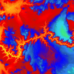
미국을 위한 Seamless 3DEP DEM 데이터 세트로, 미국 본토 48개 주, 하와이, 미국 영토를 완전히 포함합니다. 알래스카는 현재 일부만 제공되며 알래스카 지도 제작 이니셔티브의 일환으로 주 전체를 포함하도록 확장되고 있습니다. 지상 간격은 … 3dep dem elevation elevation-topography geophysical topography -
USGS 3DEP 1m 국립 지도
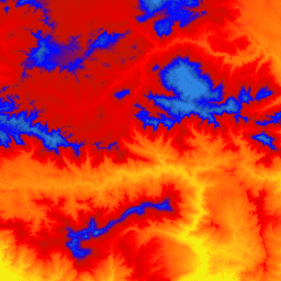
3D 고도 프로그램 (3DEP)의 1m 픽셀 크기를 갖는 이미지의 타일식 컬렉션입니다. 3DEP 데이터 보유량은 국립 지도의 고도 레이어 역할을 하며 미국에서 지구과학 연구 및 지도 제작 애플리케이션을 위한 기본적인 고도 정보를 제공합니다. 3dep dem elevation elevation-topography geophysical topography -
USGS 3DEP 국립 지도 공간 메타데이터 1/3초 (10m)

3DEP 10m DEM 애셋의 메타데이터가 포함된 테이블입니다. 작업 단위 범위 공간 메타데이터 (WESM)에는 현재 LiDAR 데이터 가용성 및 LiDAR 품질 수준, 데이터 수집 날짜, 프로젝트 수준 메타데이터 링크를 비롯한 LiDAR 프로젝트에 관한 기본 정보가 포함되어 있습니다. 자세한 내용은 다음 페이지를 참고하세요. 3dep elevation-topography table usgs
Datasets tagged 3dep in Earth Engine
[null,null,[],[],["The USGS 3DEP dataset offers seamless DEM data for the US, including the 48 contiguous states, Hawaii, and US territories, with partial coverage of Alaska that is being expanded. This data is available at 10m and 1m resolution. The 10m DEM has corresponding metadata table for lidar data availability. This 3DEP information serves as the elevation layer for the National Map and supports earth science studies and mapping applications.\n"]]