-
BLM AIM TerrADat TerrestrialAIM Point v1

2011년부터 미국 토지 관리국 (BLM)은 평가 인벤토리 및 모니터링 (AIM) 전략을 통해 토지 상태에 관한 정보를 제공하기 위해 현장 정보를 수집해 왔습니다. 지금까지 BLM 토지에서 6,000개가 넘는 지상 AIM 필드 플롯이 수집되었습니다. BLM AIM 데이터 보관 파일은 … blm ecosystems hydrology range soil table -
NLCD 2019: USGS National Land Cover Database, 2019년 출시
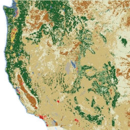
NLCD (National Land Cover Database)는 8개 시대 (2001, 2004, 2006, 2008, 2011, 2013, 2016, 2019)에 걸쳐 있는 30m Landsat 기반 토지 피복 데이터베이스입니다. 2021년의 9번째 에포크도 여기에서 확인할 수 있습니다. 이 이미지는 도시의 불투수성 데이터 레이어를 기반으로 합니다. blm landcover landuse-landcover mrlc nlcd usgs -
NLCD 2021: USGS National Land Cover Database, 2021년 출시
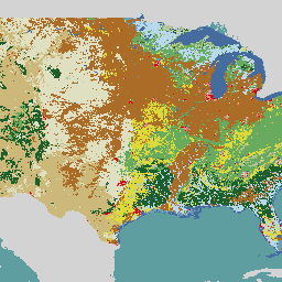
미국 지질조사국(USGS)은 여러 연방 기관과 협력하여 현재 7개의 National Land Cover Database(NLCD) 제품(NLCD 1992, 2001, 2006, 2011, 2016, 2019, 2021)을 개발하여 출시했습니다. 2016년 출시부터 토지 피복 제품은 2~3년 간격으로 생성되었습니다. blm landcover landuse-landcover mrlc nlcd usgs
Datasets tagged blm in Earth Engine
[null,null,[],[],["The Bureau of Land Management (BLM) has collected over 6,000 terrestrial field plots since 2011 to assess land health through its AIM strategy. The USGS, in collaboration with federal agencies, has created the National Land Cover Database (NLCD), available for multiple epochs (2001-2021), updating land cover data. The NLCD utilizes 30-m Landsat-based imagery and is available from multiple years with two to three year intervals from 2016 onward.\n"]]