-
GHSL: 2018년 전 세계 건물 높이 (P2023A)
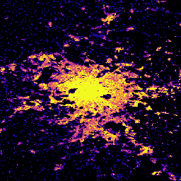
이 공간 래스터 데이터 세트는 2018년을 기준으로 100m 해상도의 전 세계 건물 높이 분포를 보여줍니다. 건물 높이를 예측하는 데 사용되는 입력 데이터는 ALOS Global Digital Surface Model (30m), NASA Shuttle Radar Topographic Mission … alos building built built-environment builtup copernicus -
GHSL: 1975~2030년 전 세계 건물 볼륨 (P2023A)
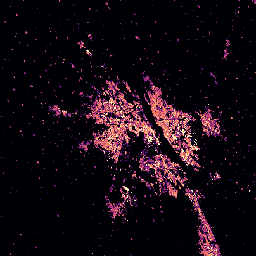
이 래스터 데이터 세트는 100m 그리드 셀당 입방미터로 표현된 건물 볼륨의 전 세계 분포를 보여줍니다. 이 데이터 세트는 총 건물 볼륨과 우세한 비주거용 (NRES) 용도 그리드 셀에 할당된 건물 볼륨을 측정합니다. 예상치는 누적된 … alos building built-environment copernicus dem ghsl -
GHSL: 전 세계 건물 표면 10m (P2023A)
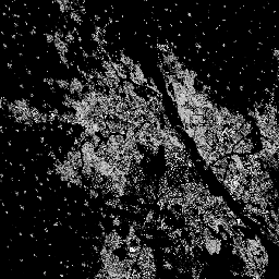
이 래스터 데이터세트는 S2 이미지 데이터에서 관찰된 2018년의 10m 그리드 셀당 제곱미터로 표현된 건물 표면의 분포를 보여줍니다. 데이터 세트는 a) 총 건물 표면과 b) …의 그리드 셀에 할당된 건물 표면을 측정합니다. built built-environment builtup copernicus ghsl jrc -
GHSL: 전 세계 건축 표면 1975~2030년 (P2023A)
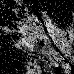
이 래스터 데이터 세트는 100m 그리드 셀당 제곱미터로 표현된 건물 표면의 분포를 보여줍니다. 이 데이터 세트는 a) 총 건물 표면과 b) 비주거용 (NRES) 용도가 주를 이루는 그리드 셀에 할당된 건물 표면을 측정합니다. 데이터가 시공간적으로 보간되거나 … built built-environment builtup copernicus ghsl jrc
Datasets tagged built-environment in Earth Engine
[null,null,[],[],["The content describes four spatial raster datasets from the Global Human Settlement Layer (GHSL). One dataset maps global building heights in 2018 at 100m resolution. Two datasets map built-up surfaces: one at 100m resolution from 1975-2030, and another at 10m resolution for 2018. These built up surfaces also differentiate between residential and non-residential. The final dataset details the global building volume from 1975-2030, measured in cubic meters per 100m grid cell.\n"]]