-
CHIRPS 강수량 일일 거의 실시간: Climate Hazards Center InfraRed Precipitation With Station Data (버전 3.0, IMERG 기반)

Climate Hazards Center Infrared Precipitation with Stations (CHIRPS v3)는 40년 이상 된 고해상도 준전역 강우량 데이터 세트입니다. 북위 60도에서 남위 60도까지 걸쳐 있으며 모든 경도를 포함하고 1981년부터 현재까지의 데이터를 제공합니다. CHIRPS v3는 위성 기반 열 적외선 강우량 추정치와 현장 관측소 관측치를 결합합니다. chc climate geophysical precipitation ucsb weather -
CHIRPS 강수 일일 재분석: Climate Hazards Center InfraRed Precipitation With Station Data (버전 3.0, ERA5 기반)

Climate Hazards Center Infrared Precipitation with Stations (CHIRPS v3)는 40년 이상 된 고해상도 준전역 강우량 데이터 세트입니다. 북위 60도에서 남위 60도까지 걸쳐 있으며 모든 경도를 포함하고 1981년부터 현재까지의 데이터를 제공합니다. CHIRPS v3는 위성 기반 열 적외선 강우량 추정치와 현장 관측소 관측치를 결합합니다. chc climate geophysical precipitation ucsb weather -
CHIRPS 강수량 5일: Climate Hazards Center InfraRed Precipitation With Station Data (버전 3.0)
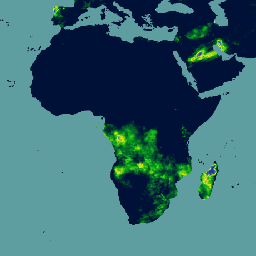
Climate Hazards Center Infrared Precipitation with Stations (CHIRPS v3)는 40년 이상 된 고해상도 준전역 강우량 데이터 세트입니다. 북위 60도에서 남위 60도까지 걸쳐 있으며 모든 경도를 포함하고 1981년부터 현재까지의 데이터를 제공합니다. CHIRPS v3는 위성 기반 열 적외선 강우량 추정치와 현장 관측소 관측치를 결합합니다. chc chg climate geophysical precipitation ucsb
Datasets tagged chc in Earth Engine
[null,null,[],[],[]]