-
OpenLandMap 점토 함량
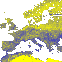
토양 단면 및 샘플의 전역 컴파일에서 가져온 머신러닝 예측을 기반으로 250m 해상도에서 6가지 표준 깊이(0, 10, 30, 60, 100, 200cm)의 점토 함량(%)입니다. 처리 단계는 여기에 자세히 설명되어 있습니다. 남극은 … 점토 envirometrix opengeohub openlandmap 토양 usda -
iSDAsoil 점토 함량
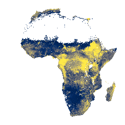
0~20cm 및 20~50cm의 토양 깊이에서 점토 함량,\n예측된 평균 및 표준 편차입니다. 밀림이 빽빽한 지역 (일반적으로 중앙 아프리카)에서는 모델 정확도가 낮으므로 밴딩 (스트라이핑)과 같은 아티팩트가 표시될 수 있습니다. 토양 속성 예측은 Innovative …에서 수행했습니다. 아프리카 점토 isda 토양
Datasets tagged clay in Earth Engine
[null,null,[],[],["The data provides information on soil clay content from two sources. The first, iSDAsoil, offers predicted mean and standard deviation of clay content for 0-20 cm and 20-50 cm depths in Africa, noting potential banding artifacts in dense jungle areas. The second, OpenLandMap, details clay content in percentages (kg/kg) at six standard depths (0-200 cm) globally, using machine learning with a 250 m resolution.\n"]]