-
加拿大 AAFC 年度作物库存

自 2009 年起,加拿大农业及农业食品部 (AAFC) 科学技术分部 (STB) 的地球观测团队开始生成年度作物类型数字地图。该研究侧重于 2009 年和 2010 年的草原省份,采用基于决策树 (DT) 的方法… 农业 加拿大 农作物 地表覆盖 -
可可概率模型 2025a

此图片集提供估计的每像素概率,表示相应区域被相应商品占据的可能性。概率估计值以 10 米为单位提供,由机器学习模型生成。如需了解详情,请参阅有关“森林数据合作伙伴计划”的技术文档… 农业 生物多样性 可可 保护 作物 eudr -
可可概率模型 2025b

此图片集提供估计的每像素概率,表示相应区域被相应商品占据的可能性。概率估计值以 10 米为单位提供,由机器学习模型生成。如需了解详情,请参阅有关“森林数据合作伙伴计划”的技术文档… 农业 alphaearth-derived 生物多样性 可可 保护 农作物 -
Coffee Probability 模型 2025a

此图片集提供估计的每像素概率,表示相应区域被相应商品占据的可能性。概率估计值以 10 米为单位提供,由机器学习模型生成。如需了解详情,请参阅有关“森林数据合作伙伴计划”的技术文档… 农业 生物多样性 咖啡 保护 作物 eudr -
Coffee Probability 模型 2025b

此图片集提供估计的每像素概率,表示相应区域被相应商品占据的可能性。概率估计值以 10 米为单位提供,由机器学习模型生成。如需了解详情,请参阅有关“森林数据合作伙伴计划”的技术文档… 农业 alphaearth-derived 生物多样性 咖啡 保护 作物 -
ESA WorldCereal 10 m v100

欧洲空间局 (ESA) WorldCereal 10 米 2021 年产品套件包含全球范围的年度和季节性作物地图及其相关置信度。这些数据是作为 ESA-WorldCereal 项目的一部分生成的。如需详细了解这些产品的内容以及用于…的方法,请参阅… 农业 哥白尼 农作物 欧洲航天局 全球 土地覆盖 -
ESA WorldCereal AEZ v100

欧洲航天局 (ESA) WorldCereal 分类系统的目标是在特定生长季结束后一个月内生成产品。由于全球各地生长季的动态特性,我们根据… 农业 边界 农作物 esa 全球 表格 -
ESA WorldCereal Active Cropland 10 m v100

欧洲空间局 (ESA) WorldCereal Active Cropland 10 m 2021 产品套件包含全球范围的季节性活跃耕地标记。这些数据是作为 ESA-WorldCereal 项目的一部分生成的。有效农田产品表示被识别为临时作物的像素是否已积极… 农业 哥白尼 农作物 欧洲航天局 全球 土地覆盖 -
EUCROPMAP

欧洲作物类型地图,基于 Sentinel-1 和 LUCAS Copernicus 2018 年实地观测数据(针对 2018 年),以及 Sentinel-1、Sentinel-2 和辅助数据与 LUCAS Copernicus 2022 年观测数据的组合(针对 2022 年)。该数据集基于独特的 LUCAS 2018 Copernicus 实地调查,是首个… agriculture crop eu jrc lucas sentinel1-derived -
GFSAD1000:农田范围 1km 多研究作物掩膜,全球粮食支持分析数据

GFSAD 是 NASA 资助的项目,旨在提供高分辨率的全球农田数据及其用水量,以促进 21 世纪的全球粮食安全。GFSAD 产品是通过多传感器遥感数据(例如 Landsat、MODIS、AVHRR)、次级数据和实地地块数据得出的… 农业 农作物 土地覆盖 usgs -
GRIDMET 干旱:美国本土干旱指数

此数据集包含从 4 公里网格化地面气象 (GRIDMET) 日数据集中派生的干旱指数。提供的干旱指数包括标准化降水指数 (SPI)、蒸发干旱需求指数 (EDDI)、标准化降水蒸散指数 (SPEI)、帕默干旱严重程度指数 (PDSI) 和帕默… 气候 conus 作物 干旱 蒸发蒸腾 地球物理 -
全球油棕种植园地图

该数据集是 2019 年全球工业和小农户油棕榈地图,分辨率为 10 米。它涵盖了检测到油棕榈种植园的区域。分类后的图片是基于 Sentinel-1 和 Sentinel-2 半年合成数据的卷积神经网络的输出。如需了解更多…,请参阅相关文章 农业 生物多样性 保护 作物 全球 土地利用 -
Palm Probability 模型 2025a

此图片集提供估计的每像素概率,表示相应区域被相应商品占据的可能性。概率估计值以 10 米为单位提供,由机器学习模型生成。如需了解详情,请参阅有关“森林数据合作伙伴计划”的技术文档… 农业 生物多样性 保护 作物 eudr forestdatapartnership -
Palm 概率模型 2025b

此图片集提供估计的每像素概率,表示相应区域被相应商品占据的可能性。概率估计值以 10 米为单位提供,由机器学习模型生成。如需了解详情,请参阅有关“森林数据合作伙伴计划”的技术文档… 农业 alphaearth-derived 生物多样性 保护 作物 eudr -
Rubber Probability 模型 2025b

此图片集提供估计的每像素概率,表示相应区域被相应商品占据的可能性。概率估计值以 10 米为单位提供,由机器学习模型生成。如需了解详情,请参阅有关“森林数据合作伙伴计划”的技术文档… 农业 alphaearth-derived 生物多样性 保护 作物 eudr -
Rubber Tree Probability 模型 2025a

此图片集提供估计的每像素概率,表示相应区域被相应商品占据的可能性。概率估计值以 10 米为单位提供,由机器学习模型生成。如需了解详情,请参阅有关“森林数据合作伙伴计划”的技术文档… 农业 生物多样性 保护 作物 eudr forestdatapartnership -
美国农业部 NASS 农田数据层
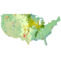
农田数据层 (CDL) 是一种特定于农作物的土地覆盖数据层,每年都会使用中等分辨率的卫星图像和广泛的农业地面实况数据为美国大陆创建。CDL 由美国农业部国家农业统计局 (NASS) 研究与开发部创建,… 农业 农作物 土地覆盖 usda
Datasets tagged crop in Earth Engine
[null,null,[],[],["Agricultural agencies and projects are creating datasets for crop mapping and analysis. Actions include generating annual crop maps, like Canada's AAFC using a Decision Tree methodology, and ESA's WorldCereal project producing global-scale crop maps. Other datasets provide oil palm plantation maps, cropland extent data, and drought indices. Recent models also estimate cocoa, palm, and rubber tree probabilities at a per-pixel level, with some data focused on specific regions like Europe, the US, or Canada, while others are global.\n"]]