LSIB 2017: বড় আকারের আন্তর্জাতিক সীমানা বহুভুজ, বিস্তারিত
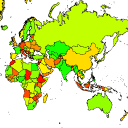
 ইউনাইটেড স্টেটস অফিস অফ দ্য জিওগ্রাফার লার্জ স্কেল ইন্টারন্যাশনাল বাউন্ডারি (LSIB) ডেটাসেট প্রদান করে। এটি অন্য দুটি ডেটাসেট থেকে নেওয়া হয়েছে: একটি LSIB লাইন ভেক্টর ফাইল এবং World Vector Shorelines (WVS) National Geospatial-Intelligence Agency (NGA) থেকে। অভ্যন্তরীণ সীমানা মার্কিন সরকারকে প্রতিফলিত করে ... সীমানা দেশগুলোর অবকাঠামো -সীমানা রাজনৈতিক ছক LSIB 2017: বড় আকারের আন্তর্জাতিক সীমানা বহুভুজ, সরলীকৃত ইউনাইটেড স্টেটস অফিস অফ দ্য জিওগ্রাফার লার্জ স্কেল ইন্টারন্যাশনাল বাউন্ডারি (LSIB) ডেটাসেট প্রদান করে। বিস্তারিত সংস্করণ (2013) অন্য দুটি ডেটাসেট থেকে নেওয়া হয়েছে: একটি LSIB লাইন ভেক্টর ফাইল এবং World Vector Shorelines (WVS) National Geospatial-Intelligence Agency (NGA) থেকে। অভ্যন্তরীণ সীমানা… সীমানা দেশগুলোর অবকাঠামো -সীমানা রাজনৈতিক ছক
Datasets tagged dos in Earth Engine
[null,null,[],[[["\u003cp\u003eThe United States Office of the Geographer provides the Large Scale International Boundary (LSIB) dataset in two versions: detailed and simplified.\u003c/p\u003e\n"],["\u003cp\u003eThe LSIB datasets reflect the U.S. government's official view of international boundaries and are derived from authoritative sources like the LSIB line vector file and World Vector Shorelines.\u003c/p\u003e\n"],["\u003cp\u003eBoth LSIB datasets include interior and disputed boundaries, offering comprehensive coverage of political borders worldwide.\u003c/p\u003e\n"]]],[],null,["# Datasets tagged dos in Earth Engine\n\n-\n\n |-----------------------------------------------------------------------------------------------------------------------------------------------------------------------------------------------------------------------------------------------------------------------------------------------------------------------------|\n | [### LSIB 2017: Large Scale International Boundary Polygons, Detailed](/earth-engine/datasets/catalog/USDOS_LSIB_2017) |\n | The United States Office of the Geographer provides the Large Scale International Boundary (LSIB) dataset. It is derived from two other datasets: a LSIB line vector file and the World Vector Shorelines (WVS) from the National Geospatial-Intelligence Agency (NGA). The interior boundaries reflect U.S. government ... |\n | [borders](/earth-engine/datasets/tags/borders) [countries](/earth-engine/datasets/tags/countries) [dos](/earth-engine/datasets/tags/dos) [infrastructure-boundaries](/earth-engine/datasets/tags/infrastructure-boundaries) [political](/earth-engine/datasets/tags/political) [table](/earth-engine/datasets/tags/table) |\n\n-\n\n |------------------------------------------------------------------------------------------------------------------------------------------------------------------------------------------------------------------------------------------------------------------------------------------------------------------------------|\n | [### LSIB 2017: Large Scale International Boundary Polygons, Simplified](/earth-engine/datasets/catalog/USDOS_LSIB_SIMPLE_2017) |\n | The United States Office of the Geographer provides the Large Scale International Boundary (LSIB) dataset. The detailed version (2013) is derived from two other datasets: a LSIB line vector file and the World Vector Shorelines (WVS) from the National Geospatial-Intelligence Agency (NGA). The interior boundaries ... |\n | [borders](/earth-engine/datasets/tags/borders) [countries](/earth-engine/datasets/tags/countries) [dos](/earth-engine/datasets/tags/dos) [infrastructure-boundaries](/earth-engine/datasets/tags/infrastructure-boundaries) [political](/earth-engine/datasets/tags/political) [table](/earth-engine/datasets/tags/table) |"]]