FIRMS: সম্পদ ব্যবস্থাপনা সিস্টেমের জন্য ফায়ার তথ্য 
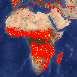
ফায়ার ইনফরমেশন ফর রিসোর্স ম্যানেজমেন্ট সিস্টেম (FIRMS) ডেটাসেটের আর্থ ইঞ্জিন সংস্করণে রাস্টারাইজড আকারে LANCE ফায়ার ডিটেকশন পণ্য রয়েছে। কাছাকাছি রিয়েল-টাইম (NRT) সক্রিয় ফায়ার অবস্থানগুলি LANCE দ্বারা স্ট্যান্ডার্ড MODIS MOD14/MYD14 ফায়ার এবং থার্মাল অ্যানোমালিস পণ্য ব্যবহার করে প্রক্রিয়া করা হয়। প্রতিটি… eosdis ফায়ার ফার্মের জিওফিজিক্যাল হটস্পট ল্যান্স VJ114IMGTDL_NRT দৈনিক রাস্টার: VIIRS (NOAA-20) ব্যান্ড 375m সক্রিয় ফায়ার NOAA-20 (JPSS-1) দৃশ্যমান ইনফ্রারেড ইমেজিং রেডিওমিটার স্যুট (VIIRS) সক্রিয় ফায়ার সনাক্তকরণ পণ্যটি যন্ত্রটির 375m নামমাত্র রেজোলিউশন ডেটার উপর ভিত্তি করে। অন্যান্য মোটা রেজোলিউশন (≥ 1 কিমি) স্যাটেলাইট অগ্নি সনাক্তকরণ পণ্যগুলির তুলনায়, উন্নত 375 মিটার ডেটা তুলনামূলকভাবে ছোট আগুনের উপর আরও বেশি প্রতিক্রিয়া প্রদান করে ... eosdis ফায়ার ফার্মের জিওফিজিক্যাল হটস্পট ল্যান্স VNP14IMGTDL_NRT দৈনিক রাস্টার: VIIRS (S-NPP) ব্যান্ড 375m সক্রিয় ফায়ার সুওমি এনপিপি ভিজিবল ইনফ্রারেড ইমেজিং রেডিওমিটার স্যুট (VIIRS) অ্যাক্টিভ ফায়ার ডিটেকশন প্রোডাক্টটি যন্ত্রটির 375m নামমাত্র রেজোলিউশন ডেটার উপর ভিত্তি করে। অন্যান্য মোটা রেজোলিউশন (≥ 1 কিমি) স্যাটেলাইট অগ্নি সনাক্তকরণ পণ্যগুলির তুলনায়, উন্নত 375 মিটার ডেটা তুলনামূলকভাবে ছোট আগুনের উপর আরও বেশি প্রতিক্রিয়া প্রদান করে ... eosdis ফায়ার ফার্মের জিওফিজিক্যাল হটস্পট ল্যান্স
Datasets tagged eosdis in Earth Engine
[null,null,[],[[["\u003cp\u003eThe Fire Information for Resource Management System (FIRMS) dataset provides near real-time active fire locations based on the MODIS MOD14/MYD14 Fire and Thermal Anomalies product.\u003c/p\u003e\n"],["\u003cp\u003eThe VIIRS Active Fire detection product offers improved 375m resolution data for greater response over smaller fires, available for both NOAA-20 and Suomi NPP satellites.\u003c/p\u003e\n"],["\u003cp\u003eAll datasets utilize LANCE (Land, Atmosphere Near real-time Capability for EOS) for fire detection and are available through Earth Engine.\u003c/p\u003e\n"]]],[],null,["# Datasets tagged eosdis in Earth Engine\n\n-\n\n |-----------------------------------------------------------------------------------------------------------------------------------------------------------------------------------------------------------------------------------------------------------------------------------------------------------------------|\n | [### FIRMS: Fire Information for Resource Management System](/earth-engine/datasets/catalog/FIRMS) |\n | The Earth Engine version of the Fire Information for Resource Management System (FIRMS) dataset contains the LANCE fire detection product in rasterized form. The near real-time (NRT) active fire locations are processed by LANCE using the standard MODIS MOD14/MYD14 Fire and Thermal Anomalies product. Each ... |\n | [eosdis](/earth-engine/datasets/tags/eosdis) [fire](/earth-engine/datasets/tags/fire) [firms](/earth-engine/datasets/tags/firms) [geophysical](/earth-engine/datasets/tags/geophysical) [hotspot](/earth-engine/datasets/tags/hotspot) [lance](/earth-engine/datasets/tags/lance) |\n\n-\n\n |---------------------------------------------------------------------------------------------------------------------------------------------------------------------------------------------------------------------------------------------------------------------------------------------------------------------------------|\n | [### VJ114IMGTDL_NRT Daily Raster: VIIRS (NOAA-20) Band 375m Active Fire](/earth-engine/datasets/catalog/NASA_LANCE_NOAA20_VIIRS_C2) |\n | NOAA-20 (JPSS-1) Visible Infrared Imaging Radiometer Suite (VIIRS) Active Fire detection product is based on the instrument's 375m nominal resolution data. Compared to other coarser resolution (≥ 1km) satellite fire detection products, the improved 375 m data provide greater response over fires of relatively small ... |\n | [eosdis](/earth-engine/datasets/tags/eosdis) [fire](/earth-engine/datasets/tags/fire) [firms](/earth-engine/datasets/tags/firms) [geophysical](/earth-engine/datasets/tags/geophysical) [hotspot](/earth-engine/datasets/tags/hotspot) [lance](/earth-engine/datasets/tags/lance) |\n\n-\n\n |--------------------------------------------------------------------------------------------------------------------------------------------------------------------------------------------------------------------------------------------------------------------------------------------------------------------------|\n | [### VNP14IMGTDL_NRT Daily Raster: VIIRS (S-NPP) Band 375m Active Fire](/earth-engine/datasets/catalog/NASA_LANCE_SNPP_VIIRS_C2) |\n | Suomi NPP Visible Infrared Imaging Radiometer Suite (VIIRS) Active Fire detection product is based on the instrument's 375m nominal resolution data. Compared to other coarser resolution (≥ 1km) satellite fire detection products, the improved 375 m data provide greater response over fires of relatively small ... |\n | [eosdis](/earth-engine/datasets/tags/eosdis) [fire](/earth-engine/datasets/tags/fire) [firms](/earth-engine/datasets/tags/firms) [geophysical](/earth-engine/datasets/tags/geophysical) [hotspot](/earth-engine/datasets/tags/hotspot) [lance](/earth-engine/datasets/tags/lance) |"]]