-
全球 ALOS CHILI(连续热量-日照负荷指数)

CHILI 是日照和地形阴影对蒸散量影响的替代指标,通过计算早午时日照量(太阳高度相当于春分)来表示。它基于 JAXA 的 ALOS DEM 的 30 米“AVE”波段(在 EE 中以 JAXA/ALOS/AW3D30_V1_1 提供)。Conservation Science … aspect csp elevation elevation-topography ergo geophysical -
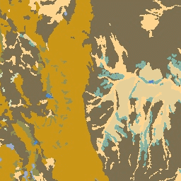
全球 ALOS 地貌

ALOS 地貌数据集提供通过组合连续热量-日照负荷指数 (ALOS CHILI) 和多尺度地形位置指数 (ALOS mTPI) 数据集创建的地貌类别。它基于 JAXA 的 ALOS DEM 的 30 米“AVE”波段(在 EE 中以 JAXA/ALOS/AW3D30_V1_1 提供)。Conservation … aspect csp elevation elevation-topography ergo geophysical -
全球 ALOS 地形多样性

地形多样性 (D) 是一个替代变量,表示物种作为当地栖息地可获得的温度和湿度条件的多样性。它表达了这样一种逻辑:地形气候生态位的多样性越高,应支持的多样性(尤其是植物)越高,并且在气候变化的情况下支持物种持久性。 … aspect csp elevation elevation-topography ergo geophysical -
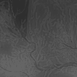
全球 ALOS mTPI(多尺度地形位置指数)

mTPI 可区分山脊和山谷形态。它是通过从每个位置的海拔数据中减去邻域内的平均海拔来计算的。mTPI 使用半径(公里)为 115.8、89.9、35.5、13.1、5.6、2.8 和 1.2 的移动窗口。它基于 30 米 … aspect csp elevation elevation-topography ergo geophysical -
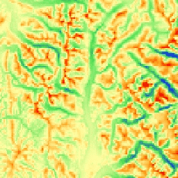
全球 SRTM CHILI(连续热量-日照负荷指数)

CHILI 是日照和地形阴影对蒸散量影响的替代指标,通过计算早午时日照量(太阳高度相当于春分)来表示。它基于 30 米 SRTM DEM(在 EE 中以 USGS/SRTMGL1_003 提供)。Conservation Science Partners (CSP) Ecologically Relevant … aspect csp elevation elevation-topography ergo geophysical -
全球 SRTM 地貌

SRTM 地貌数据集提供通过组合连续热量-日照负荷指数 (SRTM CHILI) 和多尺度地形位置指数 (SRTM mTPI) 数据集创建的地貌类别。它基于 30 米 SRTM DEM(在 EE 中以 USGS/SRTMGL1_003 提供)。Conservation Science Partners (CSP) Ecologically … aspect csp elevation elevation-topography ergo geophysical -
全球 SRTM 地形多样性

地形多样性 (D) 是一个替代变量,表示物种作为当地栖息地可获得的温度和湿度条件的多样性。它表达了这样一种逻辑:地形气候生态位的多样性越高,应支持的多样性(尤其是植物)越高,并且在气候变化的情况下支持物种持久性。 … aspect csp elevation elevation-topography ergo geophysical -
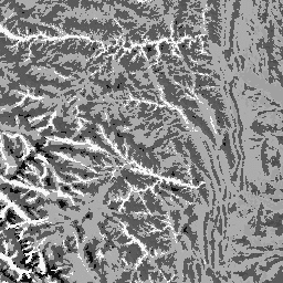
全球 SRTM mTPI(多尺度地形位置指数)

mTPI 可区分山脊和山谷形态。它是通过从每个位置的海拔数据中减去邻域内的平均海拔来计算的。mTPI 使用半径(公里)为 115.8、89.9、35.5、13.1、5.6、2.8 和 1.2 的移动窗口。它基于 30 米 … aspect csp elevation elevation-topography ergo geophysical -
美国岩性
岩性数据集提供地表土壤母质一般类型的类别。它不是从任何 DEM 派生的。Conservation Science Partners (CSP) Ecologically Relevant Geomorphology (ERGo) Datasets、Landforms and Physiography 包含有关地貌和地形的详细多尺度数据。 … aspect csp elevation elevation-topography ergo geophysical -
美国 NED CHILI(连续热量-日照负荷指数)

CHILI 是日照和地形阴影对蒸散量影响的替代指标,通过计算早午时日照量(太阳高度相当于春分)来表示。它基于 USGS 的 10 米 NED DEM(在 EE 中以 USGS/NED 提供)。Conservation Science Partners (CSP) Ecologically … aspect csp elevation elevation-topography ergo geophysical -
美国 NED 地貌

ALOS 地貌数据集提供通过组合连续热量-日照负荷指数 (CHILI) 和多尺度地形位置指数 (mTPI) 数据集创建的地貌类别。它基于 USGS 的 10 米 NED DEM(在 EE 中以 USGS/NED 提供)。Conservation Science Partners (CSP) Ecologically Relevant … aspect csp elevation elevation-topography ergo geophysical -
美国 NED 地形多样性
地形多样性数据集提供地形类型多样性的指数。它是使用香农多样性指数以多种尺度(公里)计算得出的:115.8、89.9、35.5、13.1、5.6、2.8 和 1.2。它基于 USGS 的 10 米 NED DEM(在 EE 中以 … aspect csp elevation elevation-topography ergo geophysical -
美国 NED 地形多样性

地形多样性 (D) 是一个替代变量,表示物种作为当地栖息地可获得的温度和湿度条件的多样性。它表达了这样一种逻辑:地形气候生态位的多样性越高,应支持的多样性(尤其是植物)越高,并且在气候变化的情况下支持物种持久性。 … aspect csp elevation elevation-topography ergo geophysical -
美国 NED mTPI(多尺度地形位置指数)
mTPI 可区分山脊和山谷形态。它是通过从每个位置的海拔数据中减去邻域内的平均海拔来计算的。mTPI 使用半径(公里)为 115.8、89.9、35.5、13.1、5.6、2.8 和 1.2 的移动窗口。它基于 USGS 的 … aspect csp elevation elevation-topography ergo geophysical -
美国地形
地形数据集表示地貌(在 EE 中以 ERGo/1_0/US/landforms 提供)和岩性(在 EE 中以 ERGo/1_0/US/lithology 提供)数据层的空间交集。它提供了 247 种可能的组合,总共有 270 种组合。每种类型的值都是通过连接地貌和 … aspect csp elevation elevation-topography ergo geophysical
Datasets tagged ergo in Earth Engine
[null,null,[],[],["The data includes various datasets focused on landform and topographic characteristics, utilizing Continuous Heat-Insolation Load Index (CHILI) and multi-scale Topographic Position Index (mTPI). CHILI represents insolation effects, and mTPI distinguishes ridge/valley forms using elevation data. These are used to produce landform classifications. Topographic diversity, a measure of varied temperature and moisture conditions, is also available, along with physiographic diversity. Global and US specific data sets are based on different DEMs (ALOS, SRTM, and NED).\n"]]