এস্তোনিয়া আরজিবি লো ফ্লাইং অর্থোফটোস 
অর্থোফটো হল এস্তোনিয়া জুড়ে একটি বায়বীয় ছবির ডেটাসেট। অর্থোফটো হল একটি প্রক্রিয়াজাত বায়বীয় ছবি যা থেকে ভূখণ্ডের তলদেশ, এক্সপোজারের মুহূর্তে মাটির সাপেক্ষে ক্যামেরার কাত এবং ক্যামেরার কেন্দ্রীয় প্রক্ষেপণের কারণে সৃষ্ট বিকৃতিগুলি অপসারণ করা হয়। একটি ডিজিটাল অর্থোফটোতে একটি নির্দিষ্ট ... এস্তোনিয়া লো-ফ্লাইং অর্থোফোটোস আরজিবি এস্তোনিয়া আরজিবি অর্থোফটোস 
অর্থোফটো হল এস্তোনিয়া জুড়ে একটি বায়বীয় ছবির ডেটাসেট। অর্থোফটো হল একটি প্রক্রিয়াজাত বায়বীয় ছবি যা থেকে ভূখণ্ডের তলদেশ, এক্সপোজারের মুহূর্তে মাটির সাপেক্ষে ক্যামেরার কাত এবং ক্যামেরার কেন্দ্রীয় প্রক্ষেপণের কারণে সৃষ্ট বিকৃতিগুলি অপসারণ করা হয়। একটি ডিজিটাল অর্থোফটোতে একটি নির্দিষ্ট ... এস্তোনিয়া অর্থোফোটোস আরজিবি এস্তোনিয়া মনো লো ফ্লাইং অর্থোফটোস 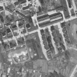
অর্থোফটো হল এস্তোনিয়া জুড়ে একটি বায়বীয় ছবির ডেটাসেট। অর্থোফটো হল একটি প্রক্রিয়াজাত বায়বীয় ছবি যা থেকে ভূখণ্ডের তলদেশ, এক্সপোজারের মুহূর্তে মাটির সাপেক্ষে ক্যামেরার কাত এবং ক্যামেরার কেন্দ্রীয় প্রক্ষেপণের কারণে সৃষ্ট বিকৃতিগুলি অপসারণ করা হয়। একটি ডিজিটাল অর্থোফটোতে একটি নির্দিষ্ট ... এস্তোনিয়া লো-ফ্লাইং অর্থোফোটোস এস্তোনিয়া মনো অর্থোফোটোস 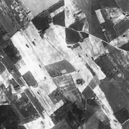
অর্থোফটো হল এস্তোনিয়া জুড়ে একটি বায়বীয় ছবির ডেটাসেট। অর্থোফটো হল একটি প্রক্রিয়াজাত বায়বীয় ছবি যা থেকে ভূখণ্ডের তলদেশ, এক্সপোজারের মুহূর্তে মাটির সাপেক্ষে ক্যামেরার কাত এবং ক্যামেরার কেন্দ্রীয় প্রক্ষেপণের কারণে সৃষ্ট বিকৃতিগুলি অপসারণ করা হয়। একটি ডিজিটাল অর্থোফটোতে একটি নির্দিষ্ট ... এস্তোনিয়া অর্থোফোটোস
Datasets tagged estonia in Earth Engine
[null,null,[],[],["The content describes aerial photo datasets, known as orthophotos, covering Estonia. These processed photos correct distortions from terrain, camera tilt, and central projection. There are mono and RGB orthophoto datasets, with some designated as low-flying. The datasets are tagged with \"estonia,\" \"orthophoto,\" and either \"rgb\" or \"low-flying\", depending on the specific characteristics of each set.\n"]]