-
NOAA CDR AVHRR LAI FAPAR: Leaf Area Index and Fraction of Absorbed Photosynthetically Active Radiation, Version 5(NOAA CDR AVHRR LAI FAPAR: 잎 면적 지수 및 흡수된 광합성 활성 방사선 비율, 버전 5)

AVHRR 잎 면적 지수 (LAI) 및 광합성 활성 방사선 흡수율 (FAPAR) 데이터 세트의 NOAA 기후 데이터 기록 (CDR)에는 식물의 수관 및 광합성 활동을 특징짓는 파생 값이 포함되어 있습니다. 이 데이터 세트는 NOAA AVHRR 표면 반사율 제품에서 파생되었으며 … avhrr cdr daily fapar lai land -
NOAA CDR VIIRS LAI FAPAR: Leaf Area Index and Fraction of Absorbed Photosynthetically Active Radiation, Version 1(NOAA CDR VIIRS LAI FAPAR: 잎 면적 지수 및 흡수된 광합성 활성 방사선 비율, 버전 1)

이 기후 데이터 기록 (CDR)은 식물 스트레스를 평가하고, 농업 수확량을 예측하고, 기타 모델링 및 리소스 관리 애플리케이션에 사용할 수 있는 두 가지 생물리학적 변수인 잎 면적 지수 (LAI)와 흡수된 광합성 활성 방사선 비율 (FAPAR)의 데이터 세트를 결합합니다. LAI는 일방적인 … cdr daily fapar lai land noaa -
OpenLandMap 잠재 FAPAR 월별
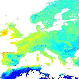
잠재적 자연 식생 FAPAR의 월별 중앙값 (PROB-V FAPAR 2014~2017 기반) 설명. Earth Engine 외부에서 지도에 액세스하고 시각화하려면 이 페이지를 사용하세요. LandGIS 지도에서 버그, 아티팩트 또는 불일치를 발견하거나 질문이 있는 경우 다음을 사용하세요. envirometrix fapar monthly opengeohub openlandmap plant-productivity
Datasets tagged fapar in Earth Engine
[null,null,[],[],[]]