-
芬兰 NRG NLS 正射影像(50 厘米)- Mavi
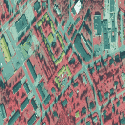
NLS 正射影像是覆盖整个芬兰的航空照片数据集。这些数据由 Mavi(农村事务局)提供。正射影像是多张单独的航空照片的组合。正射影像格式的航空照片数据集可作为最新数据集使用… falsecolor finland nrg orthophotos -
芬兰 NRG NLS 正射影像(50 厘米)- SMK

NLS 正射影像是覆盖整个芬兰的航空照片数据集。这些数据由 SMK(能源署,前身为 SMK)提供。正射影像是多张单独的航空照片的组合。正射影像格式的航空照片数据集可作为最… falsecolor finland nrg orthophotos smk -
SMK 提供的芬兰 RGB NLS 正射影像 50 厘米

NLS 正射影像是覆盖整个芬兰的航空照片数据集。这些数据由 SMK(能源署,前身为 SMK)提供。正射影像是多张单独的航空照片的组合。正射影像格式的航空照片数据集可作为… 芬兰 正射影像 rgb smk
Datasets tagged finland in Earth Engine
[null,null,[],[],["Finland's aerial photo data, known as NLS Orthophotos, is available as orthophotos, created from combined individual aerial photos. Datasets cover all of Finland and are provided by Mavi (Agency for Rural Affairs) and SMK (The Energy Agency). The data is available in orthophoto format with 50 cm resolution, with one dataset tagged as RGB and two datasets tagged as NRG (falsecolor). These datasets are considered the most recent datasets.\n"]]