-
FIRMS: Fire Information for Resource Management System
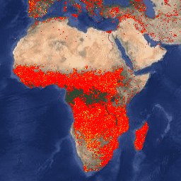
הגרסה של Earth Engine למערך הנתונים של מערכת המידע על שריפות לניהול משאבים (FIRMS) מכילה את המוצר של LANCE לזיהוי שריפות בפורמט רסטר. המיקומים של שריפות פעילות בזמן אמת (NRT) עוברים עיבוד על ידי LANCE באמצעות המוצר הסטנדרטי MODIS MOD14/MYD14 Fire and Thermal Anomalies. כל … eosdis fire firms geophysical hotspot lance -
VJ114IMGTDL_NRT Daily Raster: VIIRS (NOAA-20) Band 375m Active Fire
המוצר של NOAA-20 (JPSS-1) לזיהוי שריפות פעילות מבוסס על נתונים ברזולוציה נומינלית של 375 מ' מהמכשיר. בהשוואה למוצרים אחרים לזיהוי שריפות מלוויינים ברזולוציה גסה יותר (≥ 1 ק"מ), הנתונים המשופרים ברזולוציה של 375 מ' מספקים תגובה טובה יותר לגבי שריפות קטנות יחסית… eosdis fire firms geophysical hotspot lance -
VNP14IMGTDL_NRT Daily Raster: VIIRS (S-NPP) Band 375m Active Fire
המוצר של Suomi NPP Visible Infrared Imaging Radiometer Suite (VIIRS) לזיהוי שריפות פעילות מבוסס על נתונים ברזולוציה נומינלית של 375 מ' של המכשיר. בהשוואה למוצרים אחרים לזיהוי שריפות מלוויינים ברזולוציה גסה יותר (≥ 1 ק"מ), הנתונים המשופרים ברזולוציה של 375 מ' מספקים תגובה טובה יותר לגבי שריפות קטנות יחסית… eosdis fire firms geophysical hotspot lance
Datasets tagged firms in Earth Engine
[null,null,[],[[["\u003cp\u003eThe Fire Information for Resource Management System (FIRMS) dataset provides near real-time active fire locations, processed from MODIS data.\u003c/p\u003e\n"],["\u003cp\u003eVIIRS Active Fire detection products from both NOAA-20 and Suomi NPP offer 375m resolution data for improved fire detection, especially for smaller fires.\u003c/p\u003e\n"],["\u003cp\u003eThese datasets are part of the Earth Engine platform and are tagged with relevant keywords for easy discoverability.\u003c/p\u003e\n"]]],[],null,["# Datasets tagged firms in Earth Engine\n\n-\n\n |-----------------------------------------------------------------------------------------------------------------------------------------------------------------------------------------------------------------------------------------------------------------------------------------------------------------------|\n | [### FIRMS: Fire Information for Resource Management System](/earth-engine/datasets/catalog/FIRMS) |\n | The Earth Engine version of the Fire Information for Resource Management System (FIRMS) dataset contains the LANCE fire detection product in rasterized form. The near real-time (NRT) active fire locations are processed by LANCE using the standard MODIS MOD14/MYD14 Fire and Thermal Anomalies product. Each ... |\n | [eosdis](/earth-engine/datasets/tags/eosdis) [fire](/earth-engine/datasets/tags/fire) [firms](/earth-engine/datasets/tags/firms) [geophysical](/earth-engine/datasets/tags/geophysical) [hotspot](/earth-engine/datasets/tags/hotspot) [lance](/earth-engine/datasets/tags/lance) |\n\n-\n\n |---------------------------------------------------------------------------------------------------------------------------------------------------------------------------------------------------------------------------------------------------------------------------------------------------------------------------------|\n | [### VJ114IMGTDL_NRT Daily Raster: VIIRS (NOAA-20) Band 375m Active Fire](/earth-engine/datasets/catalog/NASA_LANCE_NOAA20_VIIRS_C2) |\n | NOAA-20 (JPSS-1) Visible Infrared Imaging Radiometer Suite (VIIRS) Active Fire detection product is based on the instrument's 375m nominal resolution data. Compared to other coarser resolution (≥ 1km) satellite fire detection products, the improved 375 m data provide greater response over fires of relatively small ... |\n | [eosdis](/earth-engine/datasets/tags/eosdis) [fire](/earth-engine/datasets/tags/fire) [firms](/earth-engine/datasets/tags/firms) [geophysical](/earth-engine/datasets/tags/geophysical) [hotspot](/earth-engine/datasets/tags/hotspot) [lance](/earth-engine/datasets/tags/lance) |\n\n-\n\n |--------------------------------------------------------------------------------------------------------------------------------------------------------------------------------------------------------------------------------------------------------------------------------------------------------------------------|\n | [### VNP14IMGTDL_NRT Daily Raster: VIIRS (S-NPP) Band 375m Active Fire](/earth-engine/datasets/catalog/NASA_LANCE_SNPP_VIIRS_C2) |\n | Suomi NPP Visible Infrared Imaging Radiometer Suite (VIIRS) Active Fire detection product is based on the instrument's 375m nominal resolution data. Compared to other coarser resolution (≥ 1km) satellite fire detection products, the improved 375 m data provide greater response over fires of relatively small ... |\n | [eosdis](/earth-engine/datasets/tags/eosdis) [fire](/earth-engine/datasets/tags/fire) [firms](/earth-engine/datasets/tags/firms) [geophysical](/earth-engine/datasets/tags/geophysical) [hotspot](/earth-engine/datasets/tags/hotspot) [lance](/earth-engine/datasets/tags/lance) |"]]