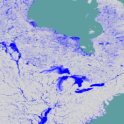
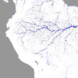
-
Global Flood Database v1 (2000~2018년)
Global Flood Database에는 2000~2018년에 발생한 913건의 홍수 이벤트의 범위와 시간 분포 지도가 포함되어 있습니다. 자세한 내용은 관련 학술지 논문을 참고하세요. 다트머스 홍수 관측소에서 홍수 이벤트를 수집하여 MODIS 이미지를 수집하는 데 사용했습니다. 선택한 913 … flood surface surface-ground-water water -
JRC 전 세계 하천 홍수 위험 지도 버전 1[지원 중단됨]
전 세계 하천 홍수 위험 지도는 7가지 다른 홍수 재발 주기 (10년에 한 번에서 500년에 한 번)에 대해 하천 네트워크를 따라 침수를 나타내는 그리드 데이터 세트입니다. 새 지도의 입력 하천 유량 데이터는 오픈소스 수문학 모델을 통해 생성됩니다. 홍수 모니터링 지표수-지하수 wri -
JRC Global River Flood Hazard Maps Version 2
전 세계 하천 홍수 위험 지도는 7가지 다른 홍수 재발 주기 (10년에 한 번에서 500년에 한 번)에 대해 하천 네트워크를 따라 침수를 나타내는 그리드 데이터 세트입니다. 새 지도의 입력 하천 유량 데이터는 오픈소스 수문학 모델을 통해 생성됩니다. 홍수 모니터링 지표수-지하수 wri -
WRI Aqueduct 기준 연간 버전 4.0
Aqueduct 4.0은 복잡한 수문학적 데이터를 직관적인 물 관련 위험 지표로 변환하도록 설계된 WRI의 최신 물 위험 프레임워크입니다. 이 데이터 세트는 수량, 품질, 평판 관련 우려사항에 대한 13가지 물 위험 지표를 포괄적인 프레임워크로 정리했습니다. 5개 중 … 수도교 홍수 모니터링 지표수-지하수 표 wri -
WRI Aqueduct 기준 월별 버전 4.0
Aqueduct 4.0은 복잡한 수문학적 데이터를 직관적인 물 관련 위험 지표로 변환하도록 설계된 WRI의 최신 물 위험 프레임워크입니다. 이 데이터 세트는 수량, 품질, 평판 관련 우려사항에 대한 13가지 물 위험 지표를 포괄적인 프레임워크로 정리했습니다. 5개 중 … 수도교 홍수 모니터링 지표수-지하수 표 wri -
WRI Aqueduct Floods Hazard Maps Version 2
Aqueduct Floods 데이터는 현재 기준 조건과 2030년, 2050년, 2080년의 미래 예측에 따라 하천 및 해안 지역의 홍수 위험을 측정합니다. Aqueduct Floods는 위험 지도를 제공하고 위험을 평가하는 것 외에도 제방의 가치를 평가하기 위한 포괄적인 비용 편익 분석을 수행하는 데 도움이 됩니다. 홍수 모니터링 지표수-지하수 wri -
WRI Aqueduct Future Annual Version 4.0
Aqueduct 4.0은 복잡한 수문학적 데이터를 직관적인 물 관련 위험 지표로 변환하도록 설계된 WRI의 최신 물 위험 프레임워크입니다. 이 데이터 세트는 수량, 품질, 평판 관련 우려사항에 대한 13가지 물 위험 지표를 포괄적인 프레임워크로 정리했습니다. 5개 중 … 수도교 홍수 모니터링 지표수-지하수 표 wri
Datasets tagged flood in Earth Engine
[null,null,[],[[["\u003cp\u003eThe Global Flood Database provides maps of 913 flood events from 2000-2018, using MODIS imagery and data from the Dartmouth Flood Observatory.\u003c/p\u003e\n"],["\u003cp\u003eJRC Global River Flood Hazard Maps offer inundation data for various flood return periods, utilizing an open-source hydrological model.\u003c/p\u003e\n"],["\u003cp\u003eWRI Aqueduct Floods Hazard Maps measure current and future riverine and coastal flood risks, including projections for 2030, 2050, and 2080.\u003c/p\u003e\n"]]],["The datasets provide information on global flood events and water risk. The Global Flood Database maps 913 flood events from 2000-2018 using MODIS imagery. The JRC Global River Flood Hazard Maps offer gridded data on river inundation for various flood return periods. WRI Aqueduct Floods data assess riverine and coastal flood risks, including future projections. Aqueduct 4.0 datasets contain 13 water risk indicators related to quantity, quality, and reputational concerns.\n"],null,["# Datasets tagged flood in Earth Engine\n\n-\n\n |---------------------------------------------------------------------------------------------------------------------------------------------------------------------------------------------------------------------------------------------------------------------------------------------------------------------|\n | [### Global Flood Database v1 (2000-2018)](/earth-engine/datasets/catalog/GLOBAL_FLOOD_DB_MODIS_EVENTS_V1) |\n | The Global Flood Database contains maps of the extent and temporal distribution of 913 flood events occurring between 2000-2018. For more information, see the associated journal article. Flood events were collected from the Dartmouth Flood Observatory and used to collect MODIS imagery. The selected 913 ... |\n | [flood](/earth-engine/datasets/tags/flood) [surface](/earth-engine/datasets/tags/surface) [surface-ground-water](/earth-engine/datasets/tags/surface-ground-water) [water](/earth-engine/datasets/tags/water) |\n\n-\n\n |--------------------------------------------------------------------------------------------------------------------------------------------------------------------------------------------------------------------------------------------------------------------------------------------------------|\n | [### JRC Global River Flood Hazard Maps Version 1 \\[deprecated\\]](/earth-engine/datasets/catalog/JRC_CEMS_GLOFAS_FloodHazard_v1) |\n | The global river flood hazard maps are a gridded data set representing inundation along the river network, for seven different flood return periods (from 1-in-10-years to 1-in-500-years). The input river flow data for the new maps are produced by means of the open-source hydrological model ... |\n | [flood](/earth-engine/datasets/tags/flood) [monitoring](/earth-engine/datasets/tags/monitoring) [surface-ground-water](/earth-engine/datasets/tags/surface-ground-water) [wri](/earth-engine/datasets/tags/wri) |\n\n-\n\n |--------------------------------------------------------------------------------------------------------------------------------------------------------------------------------------------------------------------------------------------------------------------------------------------------------|\n | [### JRC Global River Flood Hazard Maps Version 2](/earth-engine/datasets/catalog/JRC_CEMS_GLOFAS_FloodHazard_v2) |\n | The global river flood hazard maps are a gridded data set representing inundation along the river network, for seven different flood return periods (from 1-in-10-years to 1-in-500-years). The input river flow data for the new maps are produced by means of the open-source hydrological model ... |\n | [flood](/earth-engine/datasets/tags/flood) [monitoring](/earth-engine/datasets/tags/monitoring) [surface-ground-water](/earth-engine/datasets/tags/surface-ground-water) [wri](/earth-engine/datasets/tags/wri) |\n\n-\n\n |--------------------------------------------------------------------------------------------------------------------------------------------------------------------------------------------------------------------------------------------------------------------------------------------------------------------|\n | [### WRI Aqueduct Baseline Annual Version 4.0](/earth-engine/datasets/catalog/WRI_Aqueduct_Water_Risk_V4_baseline_annual) |\n | Aqueduct 4.0 is the latest iteration of WRI's water risk framework designed to translate complex hydrological data into intuitive indicators of water related risk. This dataset has curated 13 water risk indicators for quantity, quality and reputational concerns into a comprehensive framework. For 5 of ... |\n | [aqueduct](/earth-engine/datasets/tags/aqueduct) [flood](/earth-engine/datasets/tags/flood) [monitoring](/earth-engine/datasets/tags/monitoring) [surface-ground-water](/earth-engine/datasets/tags/surface-ground-water) [table](/earth-engine/datasets/tags/table) [wri](/earth-engine/datasets/tags/wri) |\n\n-\n\n |--------------------------------------------------------------------------------------------------------------------------------------------------------------------------------------------------------------------------------------------------------------------------------------------------------------------|\n | [### WRI Aqueduct Baseline Monthly Version 4.0](/earth-engine/datasets/catalog/WRI_Aqueduct_Water_Risk_V4_baseline_monthly) |\n | Aqueduct 4.0 is the latest iteration of WRI's water risk framework designed to translate complex hydrological data into intuitive indicators of water related risk. This dataset has curated 13 water risk indicators for quantity, quality and reputational concerns into a comprehensive framework. For 5 of ... |\n | [aqueduct](/earth-engine/datasets/tags/aqueduct) [flood](/earth-engine/datasets/tags/flood) [monitoring](/earth-engine/datasets/tags/monitoring) [surface-ground-water](/earth-engine/datasets/tags/surface-ground-water) [table](/earth-engine/datasets/tags/table) [wri](/earth-engine/datasets/tags/wri) |\n\n-\n\n |-----------------------------------------------------------------------------------------------------------------------------------------------------------------------------------------------------------------------------------------------------------------------------------------------------------------------|\n | [### WRI Aqueduct Floods Hazard Maps Version 2](/earth-engine/datasets/catalog/WRI_Aqueduct_Flood_Hazard_Maps_V2) |\n | Aqueduct Floods data measures riverine and coastal food risks under both current baseline conditions and future projections in 2030, 2050, and 2080. In addition to providing hazard maps and assessing risks, Aqueduct Floods helps to conduct comprehensive cost-benefit analysis to evaluate the value of dike ... |\n | [flood](/earth-engine/datasets/tags/flood) [monitoring](/earth-engine/datasets/tags/monitoring) [surface-ground-water](/earth-engine/datasets/tags/surface-ground-water) [wri](/earth-engine/datasets/tags/wri) |\n\n-\n\n |--------------------------------------------------------------------------------------------------------------------------------------------------------------------------------------------------------------------------------------------------------------------------------------------------------------------|\n | [### WRI Aqueduct Future Annual Version 4.0](/earth-engine/datasets/catalog/WRI_Aqueduct_Water_Risk_V4_future_annual) |\n | Aqueduct 4.0 is the latest iteration of WRI's water risk framework designed to translate complex hydrological data into intuitive indicators of water related risk. This dataset has curated 13 water risk indicators for quantity, quality and reputational concerns into a comprehensive framework. For 5 of ... |\n | [aqueduct](/earth-engine/datasets/tags/aqueduct) [flood](/earth-engine/datasets/tags/flood) [monitoring](/earth-engine/datasets/tags/monitoring) [surface-ground-water](/earth-engine/datasets/tags/surface-ground-water) [table](/earth-engine/datasets/tags/table) [wri](/earth-engine/datasets/tags/wri) |"]]