-
CSP gHM: Global Human Modification
קבוצת הנתונים הגלובלית של שינויים שנוצרו על ידי בני אדם (gHM) מספקת מדד מצטבר של שינויים שנוצרו על ידי בני אדם בשטחים יבשתיים ברחבי העולם ברזולוציה של קילומטר רבוע. הערכים של gHM נעים בין 0.0 ל-1.0 ומחושבים על ידי הערכת הפרופורציה של מיקום נתון (פיקסל) שעבר שינוי, העוצמה המשוערת… csp fragmentation human-modification landcover landscape-gradient population -
FireCCI51: מוצר פיקסלים של אזור שרוף Fire_cci MODIS, גרסה 5.1

MODIS Fire_cci Burned Area pixel product version 5.1 (FireCCI51) הוא מערך נתונים גלובלי חודשי ברזולוציה מרחבית של ~250m, שמכיל מידע על שטח שרוף וגם נתונים משניים. הוא מבוסס על החזרה מפני השטח בפס הקרוב לאינפרא-אדום (NIR) ממכשיר MODIS שעל גבי … burn cci climate-change copernicus esa fire -
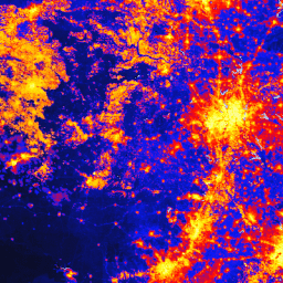
TNC Global Human Modification v3 (Static Snapshot 90m)

מערך הנתונים Global Human Modification v3 (שינוי גלובלי שנגרם על ידי בני אדם, גרסה 3) מודד את הלחצים המצטברים שמופעלים על ידי בני אדם על מערכות אקולוגיות יבשתיות גלובליות (לא כולל אנטארקטיקה). הנתונים במערך הזה מתייחסים לתקופה שבין 1990 ל-2022, והוא מיועד לעזור לכמת את ההשפעה של בני האדם על תכנון שימור, קביעת מדיניות ומחקר. זו תמונת המצב הסטטית משנת 2022 (סדרת s) … fragmentation human-modification landcover landscape-gradient population stressors
Datasets tagged fragmentation in Earth Engine
[null,null,[],[],[]]