Глобальная съемка земель Landsat 1975 г. 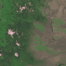
Глобальная съемка земель (GLS) 1975 года представляет собой глобальную коллекцию изображений, полученных с помощью многоспектрального сканера Landsat (MSS). Большинство изображений было получено спутниками Landsat 1-3 в 1972-1983 годах. Некоторые пробелы в данных Landsat 1-3 были заполнены изображениями, полученными Landsat 4-5 в… глобальные спутниковые снимки Landsat Radiance USGS Landsat Global Land Survey 2005, сцены Landsat 5 
Набор данных GLS2005 представляет собой коллекцию из 9500 ортотрансформированных спутниковых снимков среднего разрешения, полученных с 2004 по 2007 год и охватывающих земную сушу. GLS2005 использует в основном данные Landsat 5 и заполненные пробелами данные Landsat 7, а также данные EO-1 ALI и Terra ASTER, заполняющие любые… спутниковые снимки etm gls l5 landsat radiance Landsat Global Land Survey 2005, сцены Landsat 5+7 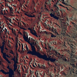
Набор данных GLS2005 представляет собой коллекцию из 9500 ортотрансформированных спутниковых снимков среднего разрешения, полученных с 2004 по 2007 год и охватывающих земную сушу. GLS2005 использует в основном данные Landsat 5 и заполненные пробелами данные Landsat 7, а также данные EO-1 ALI и Terra ASTER, заполняющие любые… спутниковые снимки gls landsat radiance usgs Landsat Global Land Survey 2005, Landsat 7 изображений 
Набор данных GLS2005 представляет собой коллекцию из 9500 ортотрансформированных спутниковых снимков среднего разрешения, полученных с 2004 по 2007 год и охватывающих земную сушу. GLS2005 использует в основном данные Landsat 5 и заполненные пробелами данные Landsat 7, а также данные EO-1 ALI и Terra ASTER, заполняющие любые… спутниковые снимки etm gls l7 landsat radiance
Datasets tagged gls in Earth Engine
[null,null,[],[],[]]