GOES-19 FDCC সিরিজ ABI লেভেল 2 ফায়ার/হট স্পট ক্যারেক্টারাইজেশন CONUS 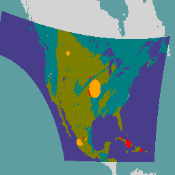
GOES স্যাটেলাইট হলো NOAA দ্বারা পরিচালিত ভূ-স্থির আবহাওয়া উপগ্রহ। ফায়ার (HSC) পণ্যটিতে চারটি ছবি রয়েছে: একটি ফায়ার মাস্কের আকারে এবং অন্য তিনটিতে পিক্সেল মান রয়েছে যা আগুনের তাপমাত্রা, আগুনের এলাকা এবং আগুনের বিকিরণ শক্তি সনাক্ত করে। ABI L2+ FHS মেটাডেটা … আবি এফডিসি ফায়ার গো গো গো-১৯ গো-ইস্ট GOES-19 FDCF সিরিজ ABI লেভেল 2 ফায়ার/হট স্পট ক্যারেক্টারাইজেশন ফুল ডিস্ক 
ফায়ার (HSC) পণ্যটিতে চারটি ছবি রয়েছে: একটি ফায়ার মাস্কের আকারে এবং অন্য তিনটিতে পিক্সেল মান রয়েছে যা আগুনের তাপমাত্রা, আগুনের ক্ষেত্র এবং আগুনের বিকিরণ শক্তি সনাক্ত করে। ABI L2+ FHS মেটাডেটা মাস্ক প্রতিটি পৃথিবী-নেভিগেট করা পিক্সেলের জন্য একটি পতাকা নির্ধারণ করে যা … আবি এফডিসি ফায়ার গো গো গো-১৯ গো-ইস্ট GOES-19 MCMIPC সিরিজ ABI লেভেল 2 ক্লাউড এবং আর্দ্রতা চিত্র CONUS 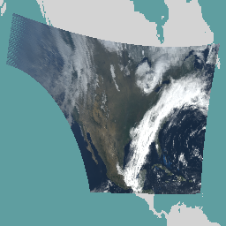
মেঘ এবং আর্দ্রতা চিত্রের পণ্যগুলি সবই ২ কিমি রেজোলিউশনে। ব্যান্ড ১-৬ প্রতিফলিত। মাত্রাবিহীন "প্রতিফলন ফ্যাক্টর" পরিমাণ সৌর জেনিথ কোণ দ্বারা স্বাভাবিক করা হয়। এই ব্যান্ডগুলি মেঘ, গাছপালা, তুষার/বরফ এবং অ্যারোসলের বৈশিষ্ট্যকে সমর্থন করে। ব্যান্ড ৭-১৬ নির্গত হয়। উজ্জ্বলতার তাপমাত্রা … আবি পরিবেশ গো গো গো-১৯ গো-পূর্ব গো-ইউ GOES-19 MCMIPF সিরিজ ABI লেভেল 2 ক্লাউড এবং আর্দ্রতা চিত্রের পূর্ণ ডিস্ক 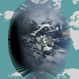
মেঘ এবং আর্দ্রতা চিত্রের পণ্যগুলি সবই ২ কিমি রেজোলিউশনে। ব্যান্ড ১-৬ প্রতিফলিত। মাত্রাবিহীন "প্রতিফলন ফ্যাক্টর" পরিমাণ সৌর জেনিথ কোণ দ্বারা স্বাভাবিক করা হয়। এই ব্যান্ডগুলি মেঘ, গাছপালা, তুষার/বরফ এবং অ্যারোসলের বৈশিষ্ট্যকে সমর্থন করে। ব্যান্ড ৭-১৬ নির্গত হয়। উজ্জ্বলতার তাপমাত্রা … আবি পরিবেশ গো গো গো-১৯ গো-পূর্ব গো-ইউ GOES-19 MCMIPM সিরিজ ABI লেভেল 2 ক্লাউড এবং আর্দ্রতা চিত্রাবলী মেসোস্কেল 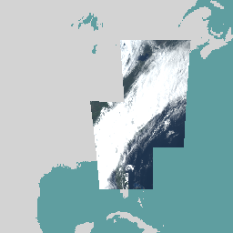
মেঘ এবং আর্দ্রতা চিত্রের পণ্যগুলি সবই ২ কিমি রেজোলিউশনে। ব্যান্ড ১-৬ প্রতিফলিত। মাত্রাবিহীন "প্রতিফলন ফ্যাক্টর" পরিমাণ সৌর জেনিথ কোণ দ্বারা স্বাভাবিক করা হয়। এই ব্যান্ডগুলি মেঘ, গাছপালা, তুষার/বরফ এবং অ্যারোসলের বৈশিষ্ট্যকে সমর্থন করে। ব্যান্ড ৭-১৬ নির্গত হয়। উজ্জ্বলতার তাপমাত্রা … আবি পরিবেশ গো গো গো-১৯ গো-পূর্ব গো-ইউ
Datasets tagged goes-19 in Earth Engine
[null,null,[],[],[]]