GOES-16 FDCC সিরিজ ABI লেভেল 2 ফায়ার/হট স্পট ক্যারেক্টারাইজেশন কনাস 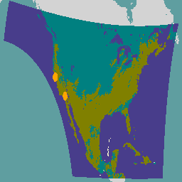
ফায়ার (HSC) পণ্যটিতে চারটি চিত্র রয়েছে: একটি ফায়ার মাস্ক আকারে এবং অন্য তিনটি পিক্সেল মান সহ আগুনের তাপমাত্রা, আগুনের এলাকা এবং অগ্নি বিকিরণ শক্তি সনাক্ত করে। ABI L2+ FHS মেটাডেটা মাস্ক প্রতিটি আর্থ-নেভিগেটেড পিক্সেলের জন্য একটি পতাকা বরাদ্দ করে যা… abi fdc fire goes -16 Goes-east GOES-16 FDCF সিরিজ ABI লেভেল 2 ফায়ার/হট স্পট ক্যারেক্টারাইজেশন ফুল ডিস্ক 
ফায়ার (HSC) পণ্যটিতে চারটি চিত্র রয়েছে: একটি ফায়ার মাস্ক আকারে এবং অন্য তিনটি পিক্সেল মান সহ আগুনের তাপমাত্রা, আগুনের এলাকা এবং অগ্নি বিকিরণ শক্তি সনাক্ত করে। ABI L2+ FHS মেটাডেটা মাস্ক প্রতিটি আর্থ-নেভিগেটেড পিক্সেলের জন্য একটি পতাকা বরাদ্দ করে যা… abi fdc fire goes -16 Goes-east GOES-16 MCMIPC সিরিজ ABI লেভেল 2 ক্লাউড এবং ময়েশ্চার ইমেজরি কনস 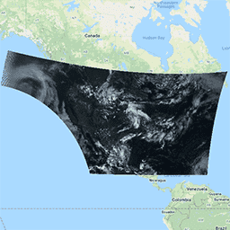
ক্লাউড এবং ময়েশ্চার ইমেজরি পণ্য সবই 2কিমি রেজোলিউশনে। ব্যান্ড 1-6 প্রতিফলিত হয়. মাত্রাবিহীন "প্রতিফলন ফ্যাক্টর" পরিমাণ সৌর জেনিথ কোণ দ্বারা স্বাভাবিক করা হয়। এই ব্যান্ডগুলি মেঘ, গাছপালা, তুষার/বরফ এবং অ্যারোসলের বৈশিষ্ট্যকে সমর্থন করে। ব্যান্ড 7-16 নির্গত হয়. উজ্জ্বলতার তাপমাত্রা… abi বায়ুমণ্ডল যায় যায়-16 যায়-পূর্ব দিকে যায়-আর GOES-16 MCMIPF সিরিজ ABI লেভেল 2 ক্লাউড এবং ময়েশ্চার ইমেজরি ফুল ডিস্ক 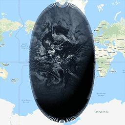
ক্লাউড এবং ময়েশ্চার ইমেজরি পণ্য সবই 2কিমি রেজোলিউশনে। ব্যান্ড 1-6 প্রতিফলিত হয়. মাত্রাবিহীন "প্রতিফলন ফ্যাক্টর" পরিমাণ সৌর জেনিথ কোণ দ্বারা স্বাভাবিক করা হয়। এই ব্যান্ডগুলি মেঘ, গাছপালা, তুষার/বরফ এবং অ্যারোসলের বৈশিষ্ট্যকে সমর্থন করে। ব্যান্ড 7-16 নির্গত হয়. উজ্জ্বলতার তাপমাত্রা… abi বায়ুমণ্ডল যায় যায়-16 যায়-পূর্ব দিকে যায়-আর GOES-16 MCMIPM সিরিজ ABI লেভেল 2 ক্লাউড এবং ময়েশ্চার ইমেজরি মেসোস্কেল 
ক্লাউড এবং ময়েশ্চার ইমেজরি পণ্য সবই 2কিমি রেজোলিউশনে। ব্যান্ড 1-6 প্রতিফলিত হয়. মাত্রাবিহীন "প্রতিফলন ফ্যাক্টর" পরিমাণ সৌর জেনিথ কোণ দ্বারা স্বাভাবিক করা হয়। এই ব্যান্ডগুলি মেঘ, গাছপালা, তুষার/বরফ এবং অ্যারোসলের বৈশিষ্ট্যকে সমর্থন করে। ব্যান্ড 7-16 নির্গত হয়. উজ্জ্বলতার তাপমাত্রা… abi বায়ুমণ্ডল যায় যায়-16 যায়-পূর্ব দিকে যায়-আর
Datasets tagged goes-r in Earth Engine
[null,null,[],[],[]]