Page Summary
-
LandScan High Definition data provides gridded population estimates at approximately 100m resolution, representing a 24-hour average population count.
-
The LandScan dataset, provided by ORNL, is a comprehensive, high-resolution global population distribution dataset created using advanced spatial modeling techniques and geospatial data sources.
-
LandScan High Definition Data for Ukraine, January 2022
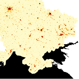
LandScan High Definition (HD) provides gridded population estimates at 3 arc-second (~100m) resolution. Values for each LandScan HD cell represent an ambient (i.e. 24 hour average) population count estimate. In this way, the data capture the full potential activity space of people throughout the course … landscan population -
LandScan Population Data Global 1km
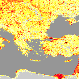
The LandScan dataset, provided by the Oak Ridge National Laboratory (ORNL), offers a comprehensive and high-resolution global population distribution dataset that serves as a valuable resource for a wide range of applications. Leveraging state-of-the-art spatial modeling techniques and advanced geospatial data sources, LandScan provides detailed … community-dataset demography landscan population sat-io