লাটভিয়া কালার ইনফ্রারেড (সিআইআর) অর্থোফটোস 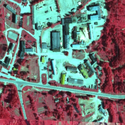
লাটভিয়ায়, TKS-93 মানচিত্র পত্র বিভাগ অনুসারে লাটভিয়ান স্থানাঙ্ক ব্যবস্থা LKS-92 TM-এ অর্থোফটো মানচিত্র প্রস্তুত করা হয় (স্কেল 1:10000 মানচিত্র পত্র প্রকৃতিতে 5 x 5 কিলোমিটারের সাথে মিলে যায়)। অর্থোফটো মানচিত্রগুলি লাটভিয়ার সমগ্র অঞ্চলের জন্য স্কেলে প্রস্তুত করা হয় ... লাটভিয়া এনআরজি অর্থোফোটোস লাটভিয়া আরজিবি অর্থোফটোস 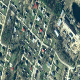
লাটভিয়ায়, TKS-93 মানচিত্র পত্র বিভাগ অনুসারে লাটভিয়ান স্থানাঙ্ক ব্যবস্থা LKS-92 TM-এ অর্থোফটো মানচিত্র প্রস্তুত করা হয় (স্কেল 1:10000 মানচিত্র পত্র প্রকৃতিতে 5 x 5 কিলোমিটারের সাথে মিলে যায়)। অর্থোফটো মানচিত্রগুলি লাটভিয়ার সমগ্র অঞ্চলের জন্য স্কেলে প্রস্তুত করা হয় ... লাটভিয়া অর্থোফোটোস আরজিবি
Datasets tagged latvia in Earth Engine
[null,null,[],[],["Orthophoto maps of Latvia are created using the LKS-92 TM coordinate system, based on the TKS-93 map sheet division. Each 1:10000 map sheet covers a 5x5 kilometer area. These maps cover the entire Latvian territory and are available in two types: Color InfraRed (CIR) and RGB. Both datasets are accessible with tags such as latvia and orthophoto.\n"]]