GlobFire দৈনিক ফায়ার ইভেন্ট সনাক্তকরণ MCD64A1 এর উপর ভিত্তি করে MODIS ডেটাসেট MCD64A1 এর উপর ভিত্তি করে ফায়ার সীমানা। একটি অ্যালগরিদমের উপর ভিত্তি করে ডেটা গণনা করা হয়েছিল যা পোড়া এলাকার প্যাচগুলির মধ্যে স্থান-কালের সম্পর্ক গ্রাফ কাঠামোতে এনকোডিংয়ের উপর নির্ভর করে। প্রতিটি অগ্নি ইভেন্ট সনাক্ত একটি অনন্য নম্বর আছে. এলাকা পোড়া দুর্যোগ আগুন গ্লোবফায়ার mcd64a1 MCD64A1 এর উপর ভিত্তি করে গ্লোবফায়ার ফাইনাল ফায়ার ইভেন্ট সনাক্তকরণ MODIS ডেটাসেট MCD64A1 এর উপর ভিত্তি করে ফায়ার সীমানা। একটি অ্যালগরিদমের উপর ভিত্তি করে ডেটা গণনা করা হয়েছিল যা পোড়া এলাকার প্যাচগুলির মধ্যে স্থান-কালের সম্পর্ক গ্রাফ কাঠামোতে এনকোডিংয়ের উপর নির্ভর করে। প্রতিটি অগ্নি ইভেন্ট সনাক্ত একটি অনন্য নম্বর আছে. এলাকা পোড়া দুর্যোগ আগুন গ্লোবফায়ার mcd64a1 MCD64A1.061 MODIS বার্নড এরিয়া মাসিক গ্লোবাল 500 মি 
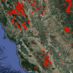
টেরা এবং অ্যাকোয়া সম্মিলিত MCD64A1 সংস্করণ 6.1 বার্নড এরিয়া ডেটা প্রোডাক্ট হল একটি মাসিক, গ্লোবাল গ্রিডেড 500m প্রোডাক্ট যাতে প্রতি-পিক্সেল বার্ন-এরিয়া এবং গুণমানের তথ্য রয়েছে। MCD64A1 বার্ন-এরিয়া ম্যাপিং পদ্ধতিতে 500m MODIS সারফেস রিফ্লেক্টেন্স ইমেজের সাথে 1km MODIS সক্রিয় অগ্নি পর্যবেক্ষণের কাজ করা হয়েছে। অ্যালগরিদম… বার্ন চেঞ্জ-ডিটেকশন ফায়ার জিওফিজিক্যাল গ্লোবাল mcd64a1
Datasets tagged mcd64a1 in Earth Engine
[null,null,[],[[["\u003cp\u003eGlobFire datasets provide daily and final fire boundaries based on the MODIS MCD64A1 dataset, using an algorithm that identifies burned areas and assigns unique identifiers to each fire event.\u003c/p\u003e\n"],["\u003cp\u003eThe MCD64A1.061 dataset offers monthly, global, 500m resolution data on burned areas, utilizing MODIS imagery and active fire observations to map burn perimeters.\u003c/p\u003e\n"],["\u003cp\u003eAll datasets use the MODIS MCD64A1 dataset, which focuses on identifying and mapping fire events and their impact.\u003c/p\u003e\n"]]],["The content describes three datasets related to fire and burned areas, all utilizing the MODIS MCD64A1 dataset. Two datasets, \"GlobFire Daily\" and \"GlobFire Final,\" provide fire boundaries, computed by an algorithm using the space-time relationships between burned patches, each with a unique identifier. The third dataset, \"MCD64A1.061,\" is a monthly global product with 500m resolution, detailing burned areas and quality using surface reflectance imagery and active fire observations.\n"],null,["# Datasets tagged mcd64a1 in Earth Engine\n\n-\n\n |-------------------------------------------------------------------------------------------------------------------------------------------------------------------------------------------------------------------------------------------------------------------------------|\n | [### GlobFire Daily Fire Event Detection Based on MCD64A1](/earth-engine/datasets/catalog/JRC_GWIS_GlobFire_v2_DailyPerimeters) |\n | Fire boundaries based on the MODIS dataset MCD64A1. The data were computed based on an algorithm that relies on encoding in a graph structure a space-time relationship among patches of burned areas. Each fire has a unique number identifying the event. |\n | [area](/earth-engine/datasets/tags/area) [burnt](/earth-engine/datasets/tags/burnt) [disaster](/earth-engine/datasets/tags/disaster) [fire](/earth-engine/datasets/tags/fire) [globfire](/earth-engine/datasets/tags/globfire) [mcd64a1](/earth-engine/datasets/tags/mcd64a1) |\n\n-\n\n |-------------------------------------------------------------------------------------------------------------------------------------------------------------------------------------------------------------------------------------------------------------------------------|\n | [### GlobFire Final Fire Event Detection Based on MCD64A1](/earth-engine/datasets/catalog/JRC_GWIS_GlobFire_v2_FinalPerimeters) |\n | Fire boundaries based on the MODIS dataset MCD64A1. The data were computed based on an algorithm that relies on encoding in a graph structure a space-time relationship among patches of burned areas. Each fire has a unique number identifying the event. |\n | [area](/earth-engine/datasets/tags/area) [burnt](/earth-engine/datasets/tags/burnt) [disaster](/earth-engine/datasets/tags/disaster) [fire](/earth-engine/datasets/tags/fire) [globfire](/earth-engine/datasets/tags/globfire) [mcd64a1](/earth-engine/datasets/tags/mcd64a1) |\n\n-\n\n |-----------------------------------------------------------------------------------------------------------------------------------------------------------------------------------------------------------------------------------------------------------------------------------------------------------------------------------------|\n | [### MCD64A1.061 MODIS Burned Area Monthly Global 500m](/earth-engine/datasets/catalog/MODIS_061_MCD64A1) |\n | The Terra and Aqua combined MCD64A1 Version 6.1 Burned Area data product is a monthly, global gridded 500m product containing per-pixel burned-area and quality information. The MCD64A1 burned-area mapping approach employs 500m MODIS Surface Reflectance imagery coupled with 1km MODIS active fire observations. The algorithm ... |\n | [burn](/earth-engine/datasets/tags/burn) [change-detection](/earth-engine/datasets/tags/change-detection) [fire](/earth-engine/datasets/tags/fire) [geophysical](/earth-engine/datasets/tags/geophysical) [global](/earth-engine/datasets/tags/global) [mcd64a1](/earth-engine/datasets/tags/mcd64a1) |"]]