মিথেনএয়ার এল৩ ঘনত্ব ভি১.১.০ 
এই ডেটাসেটটি মিথেনএয়ার ইমেজিং স্পেকট্রোমিটার দ্বারা পর্যবেক্ষণকৃত বায়ুমণ্ডলে মিথেনের মোট কলাম শুষ্ক বায়ু মোল ভগ্নাংশ, "XCH4"-এর ভূ-স্থানিক ডেটা সরবরাহ করে। XCH4-কে মিথেনের ("CH4") মোট কলাম পরিমাণ (অণুর সংখ্যা) কে মোট পরিমাণ দ্বারা ভাগ করে সংজ্ঞায়িত করা হয়… বায়ুমণ্ডল জলবায়ু ইডিএফ ইডিএফ-মিথেনস্যাট-ইই নির্গমন জিএইচজি মিথেনএয়ার এল৩ ঘনত্ব ভি১ 
এই ডেটাসেটটি মিথেনএয়ার ইমেজিং স্পেকট্রোমিটার দ্বারা পর্যবেক্ষণকৃত বায়ুমণ্ডলে মিথেনের মোট কলাম শুষ্ক বায়ু মোল ভগ্নাংশ, "XCH4"-এর ভূ-স্থানিক ডেটা সরবরাহ করে। XCH4-কে মিথেনের ("CH4") মোট কলাম পরিমাণ (অণুর সংখ্যা) কে মোট পরিমাণ দ্বারা ভাগ করে সংজ্ঞায়িত করা হয়… বায়ুমণ্ডল জলবায়ু ইডিএফ নির্গমন জিএইচজি মিথেন মিথেনএয়ার এল৪ এলাকা উৎস ভি১ 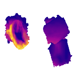
এলাকাভিত্তিক নির্গমন মডেলটি এখনও নির্মাণাধীন এবং এটি কোনো চূড়ান্ত পণ্যের প্রতিনিধিত্ব করে না। এই ডেটাসেটটি মার্কিন যুক্তরাষ্ট্র জুড়ে তেল ও গ্যাস উৎপাদনকারী অঞ্চলগুলিতে পরিচালিত মিথেনএয়ার (MethaneAIR) ফ্লাইট থেকে প্রাপ্ত পরিমাপ ব্যবহার করে স্থানিকভাবে বিভক্ত মিথেন নির্গমনের পরিমাণ (কেজি/ঘণ্টা) প্রদান করে। সমীক্ষার জন্য মোট নির্গমন… বায়ুমণ্ডল জলবায়ু ইডিএফ নির্গমন জিএইচজি মিথেন মিথেনএয়ার এল৪ পয়েন্ট সোর্স ভি১.১.০ 
এই ডেটাসেটটি পশ্চিমে কলোরাডো, নিউ মেক্সিকো এবং টেক্সাস থেকে পূর্বে পেনসিলভানিয়া, ওহাইও এবং ওয়েস্ট ভার্জিনিয়া পর্যন্ত বিস্তৃত ১৩টি তেল ও গ্যাস বা কয়লা উত্তোলন এলাকা, এবং তিনটি শহুরে এলাকা (নিউ ইয়র্ক সিটি, …) জুড়ে উচ্চ-নিঃসরণকারী মিথেন বিন্দু উৎস শনাক্তকরণের (কেজি/ঘণ্টা) তথ্য সরবরাহ করে। বায়ুমণ্ডল জলবায়ু ইডিএফ ইডিএফ-মিথেনস্যাট-ইই নির্গমন জিএইচজি মিথেনএয়ার এল৪ পয়েন্ট সোর্স ভি১ 
এই ডেটাসেটটি পশ্চিমে কলোরাডো, নিউ মেক্সিকো এবং টেক্সাস থেকে পূর্বে পেনসিলভানিয়া, ওহাইও এবং ওয়েস্ট ভার্জিনিয়া পর্যন্ত বিস্তৃত ১৩টি তেল ও গ্যাস বা কয়লা উত্তোলন এলাকা, এবং তিনটি শহুরে এলাকা (নিউ ইয়র্ক সিটি, …) জুড়ে উচ্চ-নিঃসরণকারী মিথেন বিন্দু উৎস শনাক্তকরণের (কেজি/ঘণ্টা) তথ্য সরবরাহ করে। বায়ুমণ্ডল জলবায়ু ইডিএফ নির্গমন জিএইচজি মিথেন OGIM: তেল ও গ্যাস অবকাঠামো ম্যাপিং ডেটাবেস v2.5.1 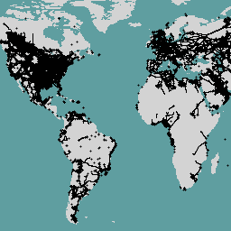
এই ডেটাসেটটি বিশ্বব্যাপী তেল ও গ্যাস (O&G) সম্পর্কিত অবকাঠামোর অবস্থান প্রদান করে। অয়েল অ্যান্ড গ্যাস ইনফ্রাস্ট্রাকচার ম্যাপিং (OGIM) ডেটাবেসটি এনভায়রনমেন্টাল ডিফেন্স ফান্ড (EDF) এবং EDF-এর একটি সম্পূর্ণ মালিকানাধীন সহায়ক সংস্থা মিথেনস্যাট এলএলসি (MethaneSAT LLC) দ্বারা বিকশিত একটি প্রকল্প। এর বিকাশের প্রাথমিক উদ্দেশ্য হলো… ইডিএফ নির্গমন জিএইচজি অবকাঠামো-সীমানা মিথেন মিথেনএয়ার
Datasets tagged methaneair in Earth Engine
[null,null,[],[],[]]