Концентрация MethaneAIR L3 V1.1.0 
Этот набор данных содержит геопространственные данные о суммарной молярной доле метана в атмосфере сухого воздуха, "XCH4", измеренной с помощью спектрометра MethaneAIR. XCH4 определяется как общее количество метана в атмосфере (число молекул), деленное на общее количество... атмосфера климат edf edf-метаны-ee выбросы парниковых газов Концентрация MethaneAIR L3 v1 
Этот набор данных содержит геопространственные данные о суммарной молярной доле метана в атмосфере сухого воздуха, "XCH4", измеренной с помощью спектрометра MethaneAIR. XCH4 определяется как общее количество метана в атмосфере (число молекул), деленное на общее количество... атмосфера климат выбросы парниковых газов метан Источники метана MethaneAIR L4, версия 1 
Модель выбросов по площади все еще находится в разработке и не является окончательным вариантом. Этот набор данных предоставляет пространственно детализированные потоки выбросов метана (кг/час) на основе измерений, полученных в ходе полетов MethaneAIR, ориентированных на нефтегазодобывающие регионы по всей территории Соединенных Штатов. Общие выбросы за период исследования… атмосфера климат выбросы парниковых газов метан Точечные источники метана MethaneAIR L4 V1.1.0 
Этот набор данных содержит информацию об обнаружении источников выбросов метана с высокой интенсивностью (кг/час) в 13 районах добычи нефти, газа и угля от Колорадо, Нью-Мексико и Техаса на западе до Пенсильвании, Огайо и Западной Вирджинии на востоке, а также в трех городских районах (Нью-Йорк, …). атмосфера климат edf edf-метаны-ee выбросы парниковых газов Точечные источники метана MethaneAIR L4 v1 
Этот набор данных содержит информацию об обнаружении источников выбросов метана с высокой интенсивностью (кг/час) в 13 районах добычи нефти, газа и угля от Колорадо, Нью-Мексико и Техаса на западе до Пенсильвании, Огайо и Западной Вирджинии на востоке, а также в трех городских районах (Нью-Йорк, …). атмосфера климат выбросы парниковых газов метан OGIM: База данных карт нефтегазовой инфраструктуры, версия 2.5.1 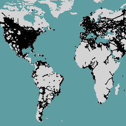
Этот набор данных содержит информацию о местоположении инфраструктуры, связанной с нефтегазовой отраслью, по всему миру. База данных «Картирование нефтегазовой инфраструктуры» (OGIM) — это проект, разработанный Фондом защиты окружающей среды (EDF) и компанией MethaneSAT LLC, дочерней компанией EDF. Основная цель разработки… выбросы ЭДФ парниковые газы границы инфраструктуры метан метановый воздух
Datasets tagged methaneair in Earth Engine
[null,null,[],[],[]]