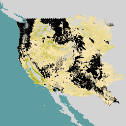
-
Tutupan Lahan Amerika Utara pada ketinggian 30 meter, 2020
Set data Penutupan Lahan Amerika Utara 30 meter tahun 2020 dibuat sebagai bagian dari North American Land Change Monitoring System (NALCMS), upaya trilateral antara Natural Resources Canada, United States Geological Survey, dan tiga organisasi Meksiko termasuk National Institute of Statistics and Geography … landcover landsat landuse-landcover nlcd reflectance -
NLCD 2019: Database Cakupan Lahan Nasional USGS, rilis 2019
NLCD (National Land Cover Database) adalah database tutupan lahan berbasis Landsat 30 m yang mencakup 8 epoch (2001, 2004, 2006, 2008, 2011, 2013, 2016, dan 2019). Epoch kesembilan untuk tahun 2021 juga tersedia di sini. Gambar ini mengandalkan lapisan data impermeabilitas untuk area perkotaan … blm landcover landuse-landcover mrlc nlcd usgs -
NLCD 2021: National Land Cover Database USGS, rilis 2021
U.S. Geological Survey (USGS), melalui kemitraan dengan beberapa lembaga federal, kini telah mengembangkan dan merilis tujuh produk National Land Cover Database (NLCD): NLCD 1992, 2001, 2006, 2011, 2016, 2019, dan 2021. Mulai rilis 2016, produk tutupan lahan dibuat untuk interval dua hingga tiga tahun … blm landcover landuse-landcover mrlc nlcd usgs -
RCMAP Rangeland Component Timeseries (1985-2023), v06
'Set data RCMAP (Penilaian dan Proyeksi Pemantauan Kondisi Padang Rumput) mengukur persentase cakupan komponen padang rumput di seluruh Amerika Utara bagian barat menggunakan citra Landsat dari tahun 1985-2023. Rangkaian produk RCMAP terdiri dari sepuluh komponen pecahan: herba tahunan, tanah kosong, herba, serasah, semak non-sagebrush, herba tahunan, sagebrush, … climate-change disturbance landsat-derived landuse-landcover nlcd rangeland -
RCMAP Rangeland Trends Year for Component Timeseries (1985-2023), v06
Koleksi ini mencakup produk tahunan RCMAP dari tahun 1985 hingga 2023. Set data RCMAP (Penilaian dan Proyeksi Pemantauan Kondisi Padang Rumput) mengukur persentase cakupan komponen padang rumput di seluruh Amerika Utara bagian barat menggunakan citra Landsat dari tahun 1985-2023. Rangkaian produk RCMAP terdiri dari sepuluh komponen pecahan: … climate-change disturbance landsat-derived landuse-landcover nlcd rangeland -
RCMAP Rangeland Trends for Component Timeseries (1985-2023), v06
Set data RCMAP (Penilaian dan Proyeksi Pemantauan Kondisi Padang Rumput) mengukur persentase cakupan komponen padang rumput di seluruh Amerika Utara bagian barat menggunakan citra Landsat dari tahun 1985-2023. Rangkaian produk RCMAP terdiri dari sepuluh komponen pecahan: herba tahunan, tanah kosong, herba, serasah, semak non-sagebrush, herba tahunan, sagebrush, … climate-change disturbance landsat-derived landuse-landcover nlcd rangeland
Datasets tagged nlcd in Earth Engine
[null,null,[],[[["\u003cp\u003eThe National Land Cover Database (NLCD) provides 30-meter resolution land cover data for the U.S. from 1992 to 2021, with the 2016 release onwards offering data in two-to-three-year intervals.\u003c/p\u003e\n"],["\u003cp\u003eThe North American Land Cover 30-meter dataset for 2020 is a collaborative effort between the U.S., Canada, and Mexico to monitor land cover changes across the continent.\u003c/p\u003e\n"],["\u003cp\u003eThe Rangeland Condition Monitoring Assessment and Projection (RCMAP) dataset quantifies percent cover of rangeland components in western North America from 1985 to 2023 using Landsat imagery, including trends analysis.\u003c/p\u003e\n"],["\u003cp\u003eRCMAP data includes ten fractional components such as annual herbaceous, bare ground, herbaceous, litter, non-sagebrush shrub, perennial herbaceous, sagebrush, and more, allowing for detailed rangeland analysis.\u003c/p\u003e\n"]]],[],null,["# Datasets tagged nlcd in Earth Engine\n\n-\n\n |------------------------------------------------------------------------------------------------------------------------------------------------------------------------------------------------------------------------------------------------------------------------------------------------------------------------------------|\n | [### Land Cover of North America at 30 meters, 2020](/earth-engine/datasets/catalog/USGS_NLCD_RELEASES_2020_REL_NALCMS) |\n | The 2020 North American Land Cover 30-meter dataset was produced as part of the North American Land Change Monitoring System (NALCMS), a trilateral effort between Natural Resources Canada, the United States Geological Survey, and three Mexican organizations including the National Institute of Statistics and Geography ... |\n | [landcover](/earth-engine/datasets/tags/landcover) [landsat](/earth-engine/datasets/tags/landsat) [landuse-landcover](/earth-engine/datasets/tags/landuse-landcover) [nlcd](/earth-engine/datasets/tags/nlcd) [reflectance](/earth-engine/datasets/tags/reflectance) |\n\n-\n\n |-----------------------------------------------------------------------------------------------------------------------------------------------------------------------------------------------------------------------------------------------------------------------------------------|\n | [### 
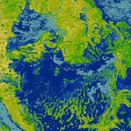
NLCD 2019: USGS National Land Cover Database, 2019 release](/earth-engine/datasets/catalog/USGS_NLCD_RELEASES_2019_REL_NLCD) |\n | NLCD (the National Land Cover Database) is a 30-m Landsat-based land cover database spanning 8 epochs (2001, 2004, 2006, 2008, 2011, 2013, 2016, and 2019). A ninth epoch for 2021 is also available here. The images rely on the imperviousness data layer for the urban ... |\n | [blm](/earth-engine/datasets/tags/blm) [landcover](/earth-engine/datasets/tags/landcover) [landuse-landcover](/earth-engine/datasets/tags/landuse-landcover) [mrlc](/earth-engine/datasets/tags/mrlc) [nlcd](/earth-engine/datasets/tags/nlcd) [usgs](/earth-engine/datasets/tags/usgs) |\n\n-\n\n |------------------------------------------------------------------------------------------------------------------------------------------------------------------------------------------------------------------------------------------------------------------------------------------------------------------------------|\n | [### 
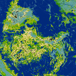
NLCD 2021: USGS National Land Cover Database, 2021 release](/earth-engine/datasets/catalog/USGS_NLCD_RELEASES_2021_REL_NLCD) |\n | The U.S. Geological Survey (USGS), in partnership with several federal agencies, has now developed and released seven National Land Cover Database (NLCD) products: NLCD 1992, 2001, 2006, 2011, 2016, 2019, and 2021. Beginning with the 2016 release, land cover products were created for two-to-three-year intervals ... |\n | [blm](/earth-engine/datasets/tags/blm) [landcover](/earth-engine/datasets/tags/landcover) [landuse-landcover](/earth-engine/datasets/tags/landuse-landcover) [mrlc](/earth-engine/datasets/tags/mrlc) [nlcd](/earth-engine/datasets/tags/nlcd) [usgs](/earth-engine/datasets/tags/usgs) |\n\n-\n\n |------------------------------------------------------------------------------------------------------------------------------------------------------------------------------------------------------------------------------------------------------------------------------------------------------------------------------------------------------------------------------------|\n | [### RCMAP Rangeland Component Timeseries (1985-2023), v06](/earth-engine/datasets/catalog/USGS_NLCD_RELEASES_2023_REL_RCMAP_V6_COVER) |\n | 'The RCMAP (Rangeland Condition Monitoring Assessment and Projection) dataset quantifies the percent cover of rangeland components across western North America using Landsat imagery from 1985-2023. The RCMAP product suite consists of ten fractional components: annual herbaceous, bare ground, herbaceous, litter, non-sagebrush shrub, perennial herbaceous, sagebrush, ... |\n | [climate-change](/earth-engine/datasets/tags/climate-change) [disturbance](/earth-engine/datasets/tags/disturbance) [landsat-derived](/earth-engine/datasets/tags/landsat-derived) [landuse-landcover](/earth-engine/datasets/tags/landuse-landcover) [nlcd](/earth-engine/datasets/tags/nlcd) [rangeland](/earth-engine/datasets/tags/rangeland) |\n\n-\n\n |-------------------------------------------------------------------------------------------------------------------------------------------------------------------------------------------------------------------------------------------------------------------------------------------------------------------------------------------------------|\n | [### RCMAP Rangeland Trends Year for Component Timeseries (1985-2023), v06](/earth-engine/datasets/catalog/USGS_NLCD_RELEASES_2023_REL_RCMAP_V6_TRENDS_YEAR) |\n | This collection includes RCMAP yearly products from 1985 through 2023. The RCMAP (Rangeland Condition Monitoring Assessment and Projection) dataset quantifies the percent cover of rangeland components across western North America using Landsat imagery from 1985-2023. The RCMAP product suite consists of ten fractional components: annual ... |\n | [climate-change](/earth-engine/datasets/tags/climate-change) [disturbance](/earth-engine/datasets/tags/disturbance) [landsat-derived](/earth-engine/datasets/tags/landsat-derived) [landuse-landcover](/earth-engine/datasets/tags/landuse-landcover) [nlcd](/earth-engine/datasets/tags/nlcd) [rangeland](/earth-engine/datasets/tags/rangeland) |\n\n-\n\n |-----------------------------------------------------------------------------------------------------------------------------------------------------------------------------------------------------------------------------------------------------------------------------------------------------------------------------------------------------------------------------------|\n | [### RCMAP Rangeland Trends for Component Timeseries (1985-2023), v06](/earth-engine/datasets/catalog/USGS_NLCD_RELEASES_2023_REL_RCMAP_V6_TRENDS) |\n | The RCMAP (Rangeland Condition Monitoring Assessment and Projection) dataset quantifies the percent cover of rangeland components across western North America using Landsat imagery from 1985-2023. The RCMAP product suite consists of ten fractional components: annual herbaceous, bare ground, herbaceous, litter, non-sagebrush shrub, perennial herbaceous, sagebrush, ... |\n | [climate-change](/earth-engine/datasets/tags/climate-change) [disturbance](/earth-engine/datasets/tags/disturbance) [landsat-derived](/earth-engine/datasets/tags/landsat-derived) [landuse-landcover](/earth-engine/datasets/tags/landuse-landcover) [nlcd](/earth-engine/datasets/tags/nlcd) [rangeland](/earth-engine/datasets/tags/rangeland) |"]]