-
आर्कटिकDEM मोज़ेक V4.1
ArcticDEM, राष्ट्रीय जियोस्पेशल इंटेलिजेंस एजेंसी (एनजीए) और नैशनल साइंस फ़ाउंडेशन (एनएसएफ़) की एक सार्वजनिक-निजी पहल है. यह ऑप्टिकल स्टीरियो तस्वीरों, बेहतरीन परफ़ॉर्मेंस वाली कंप्यूटिंग, और ओपन सोर्स फ़ोटोग्रैमिट्री सॉफ़्टवेयर का इस्तेमाल करके, आर्कटिक का हाई-रिज़ॉल्यूशन और अच्छी क्वालिटी का डिजिटल सरफ़ेस मॉडल (डीएसएम) अपने-आप तैयार करती है. इसमें पेड़-पौधों, पेड़ों से ढकी जगह, इमारतें, और ... आर्कटिक डेम ऊंचाई-स्थलाकृति भूभौतिकीय pgc उमन -
आर्कटिक डेम स्ट्रिप
ArcticDEM, राष्ट्रीय जियोस्पेशल इंटेलिजेंस एजेंसी (एनजीए) और नैशनल साइंस फ़ाउंडेशन (एनएसएफ़) की एक सार्वजनिक-निजी पहल है. यह ऑप्टिकल स्टीरियो तस्वीरों, बेहतरीन परफ़ॉर्मेंस वाली कंप्यूटिंग, और ओपन सोर्स फ़ोटोग्रैमिट्री सॉफ़्टवेयर का इस्तेमाल करके, आर्कटिक का हाई-रिज़ॉल्यूशन और अच्छी क्वालिटी का डिजिटल सरफ़ेस मॉडल (डीएसएम) अपने-आप तैयार करती है. इसमें पेड़-पौधों, पेड़ों से ढकी जगह, इमारतें, और ... आर्कटिक डेम ऊंचाई-स्थलाकृति भूभौतिकीय pgc उमन -
रेमा मोज़ेक
द रेफ़रंस एलिवेशन मॉडल ऑफ़ अंटार्कटिका (REMA), अंटार्कटिका का एक हाई रिज़ॉल्यूशन, टाइम-स्टैम्प्ड डिजिटल सर्फ़ेस मॉडल (DSM) है, जो 2-मीटर और 8-मीटर स्पेशल रिज़ॉल्यूशन पर है. मोज़ेक वाली DEM फ़ाइलें एक से ज़्यादा स्ट्रिप से इकट्ठा की जाती हैं. इन्हें एक साथ रजिस्टर किया जाता है, ब्लेंड किया जाता है, और फ़ेदर किया जाता है, ताकि किनारे से मेल खाने वाले आर्टफ़ैक्ट को कम किया जा सके. dem ऊंचाई-स्थलाकृति भूभौतिकीय pgc rema umn -
रेमा स्ट्रिप 2 मी॰
द रेफ़रंस एलिवेशन मॉडल ऑफ़ अंटार्कटिका (REMA), अंटार्कटिका का एक हाई रिज़ॉल्यूशन, टाइम-स्टैम्प्ड डिजिटल सर्फ़ेस मॉडल (DSM) है, जो 2-मीटर और 8-मीटर स्पेशल रिज़ॉल्यूशन पर है. Strip DEM फ़ाइलें, इनपुट स्टीरियोस्कोपिक इमेजरी पेयर स्ट्रिप के ओवरलैप वाले एरिया के हिसाब से होती हैं, क्योंकि वे DigitalGlobe के ... dem ऊंचाई-स्थलाकृति भूभौतिकीय pgc rema umn -
रेमा स्ट्रिप 8 मी॰
द रेफ़रंस एलिवेशन मॉडल ऑफ़ अंटार्कटिका (REMA), अंटार्कटिका का एक हाई रिज़ॉल्यूशन, टाइम-स्टैम्प्ड डिजिटल सर्फ़ेस मॉडल (DSM) है, जो 2-मीटर और 8-मीटर स्पेशल रिज़ॉल्यूशन पर है. Strip DEM फ़ाइलें, इनपुट स्टीरियोस्कोपिक इमेजरी पेयर स्ट्रिप के ओवरलैप वाले एरिया के हिसाब से होती हैं, क्योंकि वे DigitalGlobe के ... dem ऊंचाई-स्थलाकृति भूभौतिकीय pgc rema umn
Datasets tagged pgc in Earth Engine
[null,null,[],[[["\u003cp\u003eArcticDEM provides high-resolution digital surface models (DSMs) of the Arctic, including vegetation, tree canopy, buildings, and other features.\u003c/p\u003e\n"],["\u003cp\u003eREMA offers high-resolution, time-stamped DSMs of Antarctica at 2-meter and 8-meter resolutions, available as both individual strips and a mosaic.\u003c/p\u003e\n"],["\u003cp\u003eBoth ArcticDEM and REMA are products of public-private initiatives involving NGA, NSF, and PGC, utilizing optical stereo imagery and advanced computing techniques.\u003c/p\u003e\n"]]],[],null,["# Datasets tagged pgc in Earth Engine\n\n-\n\n |--------------------------------------------------------------------------------------------------------------------------------------------------------------------------------------------------------------------------------------------------------------------------------------------------------------------------------------------------------------------------------------------|\n | [### ArcticDEM Mosaic V4.1
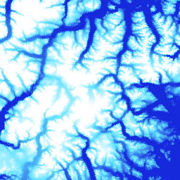
](/earth-engine/datasets/catalog/UMN_PGC_ArcticDEM_V4_2m_mosaic) |\n | ArcticDEM is a National Geospatial-Intelligence Agency (NGA) and National Science Foundation (NSF) public-private initiative to automatically produce a high-resolution, high-quality digital surface model (DSM) of the Arctic using optical stereo imagery, high-performance computing, and open source photogrammetry software. It includes vegetation, tree canopy, buildings, and ... |\n | [arctic](/earth-engine/datasets/tags/arctic) [dem](/earth-engine/datasets/tags/dem) [elevation-topography](/earth-engine/datasets/tags/elevation-topography) [geophysical](/earth-engine/datasets/tags/geophysical) [pgc](/earth-engine/datasets/tags/pgc) [umn](/earth-engine/datasets/tags/umn) |\n\n-\n\n |--------------------------------------------------------------------------------------------------------------------------------------------------------------------------------------------------------------------------------------------------------------------------------------------------------------------------------------------------------------------------------------------|\n | [### ArcticDEM Strips](/earth-engine/datasets/catalog/UMN_PGC_ArcticDEM_V3_2m) |\n | ArcticDEM is a National Geospatial-Intelligence Agency (NGA) and National Science Foundation (NSF) public-private initiative to automatically produce a high-resolution, high-quality digital surface model (DSM) of the Arctic using optical stereo imagery, high-performance computing, and open source photogrammetry software. It includes vegetation, tree canopy, buildings, and ... |\n | [arctic](/earth-engine/datasets/tags/arctic) [dem](/earth-engine/datasets/tags/dem) [elevation-topography](/earth-engine/datasets/tags/elevation-topography) [geophysical](/earth-engine/datasets/tags/geophysical) [pgc](/earth-engine/datasets/tags/pgc) [umn](/earth-engine/datasets/tags/umn) |\n\n-\n\n |---------------------------------------------------------------------------------------------------------------------------------------------------------------------------------------------------------------------------------------------------------------------------------------------------------------------------|\n | [### REMA Mosaic](/earth-engine/datasets/catalog/UMN_PGC_REMA_V1_1_8m) |\n | The Reference Elevation Model of Antarctica (REMA) is a high resolution, time-stamped Digital Surface Model (DSM) of Antarctica at 2-meter and 8-meter spatial resolutions. Mosaicked DEM files are compiled from multiple strips that have been co-registered, blended, and feathered to reduce edge-matching artifacts. |\n | [dem](/earth-engine/datasets/tags/dem) [elevation-topography](/earth-engine/datasets/tags/elevation-topography) [geophysical](/earth-engine/datasets/tags/geophysical) [pgc](/earth-engine/datasets/tags/pgc) [rema](/earth-engine/datasets/tags/rema) [umn](/earth-engine/datasets/tags/umn) |\n\n-\n\n |--------------------------------------------------------------------------------------------------------------------------------------------------------------------------------------------------------------------------------------------------------------------------------------------------------------------------|\n | [### REMA Strips 2m](/earth-engine/datasets/catalog/UMN_PGC_REMA_V1_2m) |\n | The Reference Elevation Model of Antarctica (REMA) is a high resolution, time-stamped Digital Surface Model (DSM) of Antarctica at 2-meter and 8-meter spatial resolutions. Strip DEM files correspond to the overlapping area of the input stereoscopic imagery pair strips as they are collected by DigitalGlobe's ... |\n | [dem](/earth-engine/datasets/tags/dem) [elevation-topography](/earth-engine/datasets/tags/elevation-topography) [geophysical](/earth-engine/datasets/tags/geophysical) [pgc](/earth-engine/datasets/tags/pgc) [rema](/earth-engine/datasets/tags/rema) [umn](/earth-engine/datasets/tags/umn) |\n\n-\n\n |--------------------------------------------------------------------------------------------------------------------------------------------------------------------------------------------------------------------------------------------------------------------------------------------------------------------------|\n | [### REMA Strips 8m](/earth-engine/datasets/catalog/UMN_PGC_REMA_V1_8m) |\n | The Reference Elevation Model of Antarctica (REMA) is a high resolution, time-stamped Digital Surface Model (DSM) of Antarctica at 2-meter and 8-meter spatial resolutions. Strip DEM files correspond to the overlapping area of the input stereoscopic imagery pair strips as they are collected by DigitalGlobe's ... |\n | [dem](/earth-engine/datasets/tags/dem) [elevation-topography](/earth-engine/datasets/tags/elevation-topography) [geophysical](/earth-engine/datasets/tags/geophysical) [pgc](/earth-engine/datasets/tags/pgc) [rema](/earth-engine/datasets/tags/rema) [umn](/earth-engine/datasets/tags/umn) |"]]