গ্রীষ্মমন্ডলীয় বন পর্যবেক্ষণের জন্য NICFI স্যাটেলাইট ডেটা প্রোগ্রাম বেসম্যাপ - আফ্রিকা 
এই চিত্র সংগ্রহটি গ্রীষ্মমন্ডলীয় বনের ক্ষতি হ্রাস এবং বিপরীতকরণ, জলবায়ু পরিবর্তন মোকাবেলায় অবদান, জীববৈচিত্র্য সংরক্ষণ, বন পুনরুত্পাদনে অবদান, পুনরুদ্ধার এবং বর্ধনে অবদান এবং টেকসই উন্নয়নের সুবিধার্থে প্রাথমিক উদ্দেশ্যে গ্রীষ্মমন্ডলীয় অঞ্চলের উচ্চ-রেজোলিউশন স্যাটেলাইট পর্যবেক্ষণের অ্যাক্সেস প্রদান করে, ... বেসম্যাপ বন nicfi গ্রহ planet-nicfi প্রকাশক-ডেটাসেট গ্রীষ্মমন্ডলীয় বন পর্যবেক্ষণের জন্য NICFI স্যাটেলাইট ডেটা প্রোগ্রাম বেসম্যাপ - আমেরিকা 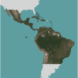
এই চিত্র সংগ্রহটি গ্রীষ্মমন্ডলীয় বনের ক্ষতি হ্রাস এবং বিপরীতকরণ, জলবায়ু পরিবর্তন মোকাবেলায় অবদান, জীববৈচিত্র্য সংরক্ষণ, বন পুনরুত্পাদনে অবদান, পুনরুদ্ধার এবং বর্ধনে অবদান এবং টেকসই উন্নয়নের সুবিধার্থে প্রাথমিক উদ্দেশ্যে গ্রীষ্মমন্ডলীয় অঞ্চলের উচ্চ-রেজোলিউশন স্যাটেলাইট পর্যবেক্ষণের অ্যাক্সেস প্রদান করে, ... বেসম্যাপ বন nicfi গ্রহ planet-nicfi প্রকাশক-ডেটাসেট গ্রীষ্মমন্ডলীয় বন পর্যবেক্ষণের জন্য NICFI স্যাটেলাইট ডেটা প্রোগ্রাম বেসম্যাপ - এশিয়া 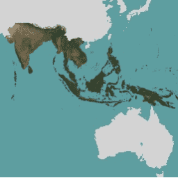
এই চিত্র সংগ্রহটি গ্রীষ্মমন্ডলীয় বনের ক্ষতি হ্রাস এবং বিপরীতকরণ, জলবায়ু পরিবর্তন মোকাবেলায় অবদান, জীববৈচিত্র্য সংরক্ষণ, বন পুনরুত্পাদনে অবদান, পুনরুদ্ধার এবং বর্ধনে অবদান এবং টেকসই উন্নয়নের সুবিধার্থে প্রাথমিক উদ্দেশ্যে গ্রীষ্মমন্ডলীয় অঞ্চলের উচ্চ-রেজোলিউশন স্যাটেলাইট পর্যবেক্ষণের অ্যাক্সেস প্রদান করে, ... বেসম্যাপ বন nicfi গ্রহ planet-nicfi প্রকাশক-ডেটাসেট
Datasets tagged planet-nicfi in Earth Engine
[null,null,[],[],["High-resolution satellite imagery is available for monitoring tropical forests across Africa, the Americas, and Asia. The data is aimed at reducing tropical forest loss and combating climate change. It also aids in biodiversity conservation, forest regrowth, restoration, and sustainable development. This program, known as NICFI, provides access to satellite data from Planet, identified as planet-nicfi, to achieve these goals. These resources are considered as basemaps.\n"]]