Мозаика Гренландии 2000 года - Проект картирования льда Гренландии (GIMP) 
Этот набор данных представляет собой полную мозаику изображений ледяного щита Гренландии с разрешением 15 м, полученную на основе радиолокационных снимков Landsat 7 ETM+ и RADARSAT-1 за период с 1999 по 2002 год. Использованные методы включают в себя комбинацию маскирования облаков изображения, повышения резкости панорамирования, выборки и изменения размера изображения… арктический GIMP изображения Гренландии НАСА полярный ЦМР 1 км, полученная с помощью криоспутника CryoSat-2 в Антарктиде 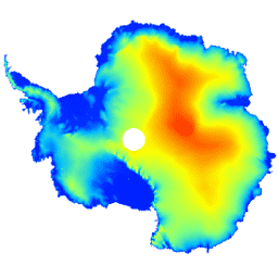
Данный набор данных представляет собой цифровую модель рельефа (ЦМР) антарктического ледового щита и шельфовых ледников, основанную на наблюдениях, зарегистрированных радиолокационным альтиметром спутника CryoSat-2 в период с июля 2010 по июль 2016 года. ЦМР формируется путем пространственно-временной подгонки к измерениям высоты, накопленным в течение 1… антарктическая высота высота -топография полярная Цифровая модель рельефа Гренландии (GIMP) 
Данная цифровая модель рельефа (ЦМР) построена на основе комбинации ЦМР ASTER и SPOT-5 для периферии и края ледяного щита (т.е. ниже линии равновесия) к югу от приблизительно 82,5° с.ш. и фотоклинометрических данных AVHRR во внутренней части ледяного щита и на крайнем севере (Скамбос и…). арктическая высота-топография GIMP Гренландия НАСА полярный Маска «Лед и океан Гренландии» — Проект картографирования Гренландии (GIMP) 
Этот набор данных содержит полные маски классификации наземного льда и океана с разрешением 15 м для ледяного щита Гренландии. Ледяной покров был нанесен на карту с использованием комбинации ортокорректированных панхроматических (диапазон 8) изображений из набора данных Landsat 7 Enhanced Thematic Mapper Plus (ETM+), распространяемого Геологической службой США, и… арктическая криосфера GIMP гренландский лед НАСА MEaSUREs Скорость движения льда в Гренландии: карты скорости движения льда на отдельных участках ледников, полученные на основе оптических изображений. Версия 2. 
Этот набор данных, являющийся частью программы НАСА «Создание записей данных о системе Земли для использования в исследовательских средах» (MEaSUREs), состоит из карт средней ежемесячной скорости для выбранных районов выхода ледников. Карты создаются путем отслеживания видимых объектов между парами оптических изображений, полученных с помощью спутника Landsat… арктическая криосфера GIMP гренландский лед НАСА
Datasets tagged polar in Earth Engine
[null,null,[],[],[]]