-
OpenLandMap 모래 콘텐츠
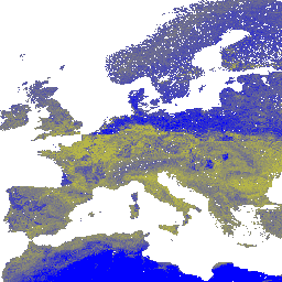
전 세계 토양 프로필 및 샘플의 머신러닝 예측을 기반으로 250m 해상도에서 6가지 표준 깊이(0, 10, 30, 60, 100, 200cm)의 모래 함량 (kg / kg)입니다. 처리 단계는 여기에 자세히 설명되어 있습니다. 남극은 … envirometrix opengeohub openlandmap sand soil usda -
iSDAsoil 모래 함량
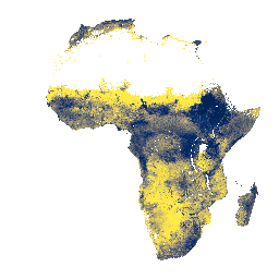
토양 깊이 0~20cm 및 20~50cm의 모래 함량, 예측 평균 및 표준 편차 밀림 지역 (일반적으로 중앙 아프리카)에서는 모델 정확도가 낮으므로 밴딩 (줄무늬)과 같은 아티팩트가 표시될 수 있습니다. 토양 속성 예측은 Innovative … africa isda sand soil
Datasets tagged sand in Earth Engine
[null,null,[],[],[]]