-
OpenLandMap Sand Content
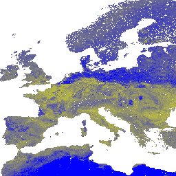
Zawartość piasku w % (kg / kg) na 6 standardowych głębokościach (0, 10, 30, 60, 100 i 200 cm) przy rozdzielczości 250 m. Na podstawie prognoz uzyskanych na podstawie uczenia maszynowego na podstawie globalnej kompilacji profili i próbek gleby. Szczegółowe instrukcje znajdziesz tutaj. Antarktyda to… envirometrix opengeohub openlandmap sand soil usda -
iSDAsoil Sand Content
Zawartość piasku na głębokości 0–20 cm i 20–50 cm,\nprzewidywana średnia i odchylenie standardowe. W obszarach gęstej dżungli (zazwyczaj w centralnej Afryce) dokładność modelu jest niska, dlatego mogą pojawiać się artefakty, takie jak paskowanie. Prognozy właściwości gleby zostały przygotowane przez Innovative … africa isda sand soil
Datasets tagged sand in Earth Engine
[null,null,[],[[["\u003cp\u003eThe iSDAsoil dataset provides predicted mean and standard deviation of sand content at soil depths of 0-20 cm and 20-50 cm for Africa, with potential lower accuracy in dense jungle regions.\u003c/p\u003e\n"],["\u003cp\u003eThe OpenLandMap dataset offers sand content percentages at six standard depths (0, 10, 30, 60, 100, and 200 cm) globally (excluding Antarctica) at 250 m resolution, based on machine learning predictions from soil profiles and samples.\u003c/p\u003e\n"]]],[],null,["# Datasets tagged sand in Earth Engine\n\n-\n\n |-------------------------------------------------------------------------------------------------------------------------------------------------------------------------------------------------------------------------------------------------------------------------------------------------|\n | [### OpenLandMap Sand Content](/earth-engine/datasets/catalog/OpenLandMap_SOL_SOL_SAND-WFRACTION_USDA-3A1A1A_M_v02) |\n | Sand content in % (kg / kg) at 6 standard depths (0, 10, 30, 60, 100 and 200 cm) at 250 m resolution Based on machine learning predictions from global compilation of soil profiles and samples. Processing steps are described in detail here. Antarctica is ... |\n | [envirometrix](/earth-engine/datasets/tags/envirometrix) [opengeohub](/earth-engine/datasets/tags/opengeohub) [openlandmap](/earth-engine/datasets/tags/openlandmap) [sand](/earth-engine/datasets/tags/sand) [soil](/earth-engine/datasets/tags/soil) [usda](/earth-engine/datasets/tags/usda) |\n\n-\n\n |-------------------------------------------------------------------------------------------------------------------------------------------------------------------------------------------------------------------------------------------------------------------------------------------------------|\n | [### iSDAsoil Sand Content](/earth-engine/datasets/catalog/ISDASOIL_Africa_v1_sand_content) |\n | Sand content at soil depths of 0-20 cm and 20-50 cm,\\\\npredicted mean and standard deviation. In areas of dense jungle (generally over central Africa), model accuracy is low and therefore artifacts such as banding (striping) might be seen. Soil property predictions were made by Innovative ... |\n | [africa](/earth-engine/datasets/tags/africa) [isda](/earth-engine/datasets/tags/isda) [sand](/earth-engine/datasets/tags/sand) [soil](/earth-engine/datasets/tags/soil) |"]]