-
מערך נתונים של בתימטריה של אגמים גלובליים (GLOBathy Global lakes bathymetry dataset)
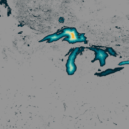
מערך הנתונים GLObal Bathymetric (GLOBathy), שכולל נתונים על יותר מ-1.4 מיליון גופי מים ברחבי העולם, פותח בקפידה כדי להתאים למערך הנתונים המוכר HydroLAKES. GLOBathy משתמשת במסגרת מתוחכמת שמבוססת על מערכת מידע גיאוגרפי (GIS) כדי ליצור מפות בתימטריות מפורטות. המערכת משלבת הערכות של עומק מקסימלי ונתונים גיאומטריים/גיאופיזיים… bathymetry community-dataset hydrology sat-io surface-ground-water -
נתוני אוכלוסייה של LandScan, ניתוח גלובלי ברזולוציה של 1 ק"מ
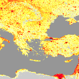
מערך הנתונים של LandScan, שמסופק על ידי Oak Ridge National Laboratory (ORNL), מציע מערך נתונים מקיף ברזולוציה גבוהה של התפלגות האוכלוסייה בעולם, שמשמש כמשאב חשוב למגוון רחב של אפליקציות. LandScan משתמש בטכניקות מתקדמות של מידול מרחבי ובמקורות מתקדמים של נתונים גיאו-מרחביים, ומספק מידע מפורט על… community-dataset demography landscan population sat-io -
United States Drought Monitor

ה-U.S. Drought Monitor (מעקב הבצורת בארה"ב) הוא מפה שמתפרסמת בכל יום חמישי, ומוצגים בה חלקים בארה"ב שסובלים מבצורת. במפה נעשה שימוש בחמישה סיווגים: יובש חריג (D0), שמשמש לסימון אזורים שאולי נכנסים לבצורת או יוצאים ממנה, וארבע רמות של בצורת: … community-dataset drought noaa precipitation sat-io usda
Datasets tagged sat-io in Earth Engine
[null,null,[],[],[]]