-
SPL3SMP_E.005 SMAP L3 Radiometer Global Daily 9 km Soil Moisture
Dane od 4 grudnia 2023 r. są dostępne w kolekcji NASA/SMAP/SPL3SMP_E/006. Ten produkt dotyczący wilgotności gleby na poziomie 3 (L3) zawiera dzienny kompozyt globalnych warunków powierzchni lądu uzyskany za pomocą radiometru pasma L (SMAP) na satelicie Soil Moisture Active Passive. Dane dzienne zostały zebrane z danych malejących (lokalnych … drought nasa smap soil soil-moisture surface -
SPL3SMP_E.006 SMAP L3 Radiometer Global Daily 9 km Soil Moisture
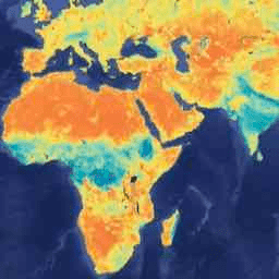
Dane sprzed 4 grudnia 2023 r. są dostępne w starszej kolekcji NASA/SMAP/SPL3SMP_E/005. Zostaną one ostatecznie ponownie przetworzone i dodane do tej kolekcji. Ten produkt dotyczący wilgotności gleby na poziomie 3 (L3) zawiera dzienny kompozyt globalnych warunków powierzchni lądu uzyskany za pomocą instrumentu Soil Moisture Active Passive (SMAP) L-Band… drought nasa smap soil soil-moisture surface -
SPL4SMGP.008 SMAP L4 Global 3-hourly 9-km Surface and Root Zone Soil Moisture
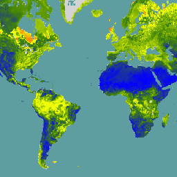
Produkt SMAP Level-4 (L4) Soil Moisture obejmuje wilgotność gleby powierzchniowej (średnia pionowa 0–5 cm), wilgotność gleby w strefie korzeniowej (średnia pionowa 0–100 cm) oraz dodatkowe produkty badawcze (niezweryfikowane), w tym zmienne wymuszające meteorologiczne na powierzchni, temperaturę gleby, ewapotranspirację i promieniowanie netto. Ten zbiór danych, formalnie znany jako … drought nasa smap soil soil-moisture surface
Datasets tagged smap in Earth Engine
[null,null,[],[[["\u003cp\u003eNASA's SMAP mission offers Level-3 (L3) daily composite soil moisture data, with SPL3SMP_E.005 covering data before December 4, 2023, and SPL3SMP_E.006 covering data from December 4, 2023, onwards.\u003c/p\u003e\n"],["\u003cp\u003eSMAP L3 data provides insights into global land surface conditions, specifically soil moisture, retrieved using the L-Band radiometer.\u003c/p\u003e\n"],["\u003cp\u003eThe SMAP Level-4 (L4) product (SPL4SMGP.007) offers 3-hourly, 9-km resolution data for surface and root zone soil moisture, along with supplementary research products like temperature, evapotranspiration, and net radiation.\u003c/p\u003e\n"]]],[],null,["# Datasets tagged smap in Earth Engine\n\n-\n\n |---------------------------------------------------------------------------------------------------------------------------------------------------------------------------------------------------------------------------------------------------------------------------------------------------------------------------------------|\n | [### SPL3SMP_E.005 SMAP L3 Radiometer Global Daily 9 km Soil Moisture](/earth-engine/datasets/catalog/NASA_SMAP_SPL3SMP_E_005) |\n | Data starting from 2023-12-04 are available in the NASA/SMAP/SPL3SMP_E/006 collection. This Level-3 (L3) soil moisture product provides a daily composite of global land surface conditions retrieved by the Soil Moisture Active Passive (SMAP) L-Band radiometer. The daily data here were collected from the descending (local ... |\n | [drought](/earth-engine/datasets/tags/drought) [nasa](/earth-engine/datasets/tags/nasa) [smap](/earth-engine/datasets/tags/smap) [soil](/earth-engine/datasets/tags/soil) [soil-moisture](/earth-engine/datasets/tags/soil-moisture) [surface](/earth-engine/datasets/tags/surface) |\n\n-\n\n |----------------------------------------------------------------------------------------------------------------------------------------------------------------------------------------------------------------------------------------------------------------------------------------------------------------------------------|\n | [### SPL3SMP_E.006 SMAP L3 Radiometer Global Daily 9 km Soil Moisture](/earth-engine/datasets/catalog/NASA_SMAP_SPL3SMP_E_006) |\n | Data prior from 2023-12-04 are available in the older NASA/SMAP/SPL3SMP_E/005 collection. They will eventually be reprocessed and added to this collection. This Level-3 (L3) soil moisture product provides a daily composite of global land surface conditions retrieved by the Soil Moisture Active Passive (SMAP) L-Band ... |\n | [drought](/earth-engine/datasets/tags/drought) [nasa](/earth-engine/datasets/tags/nasa) [smap](/earth-engine/datasets/tags/smap) [soil](/earth-engine/datasets/tags/soil) [soil-moisture](/earth-engine/datasets/tags/soil-moisture) [surface](/earth-engine/datasets/tags/surface) |\n\n-\n\n |-------------------------------------------------------------------------------------------------------------------------------------------------------------------------------------------------------------------------------------------------------------------------------------------------------------------------------------------------------------------|\n | [### SPL4SMGP.008 SMAP L4 Global 3-hourly 9-km Surface and Root Zone Soil Moisture](/earth-engine/datasets/catalog/NASA_SMAP_SPL4SMGP_008) |\n | The SMAP Level-4 (L4) Soil Moisture product includes surface soil moisture (0-5 cm vertical average), root-zone soil moisture (0-100 cm vertical average), and additional research products (not validated), including surface meteorological forcing variables, soil temperature, evapotranspiration, and net radiation. This dataset, formally known as the ... |\n | [drought](/earth-engine/datasets/tags/drought) [nasa](/earth-engine/datasets/tags/nasa) [smap](/earth-engine/datasets/tags/smap) [soil](/earth-engine/datasets/tags/soil) [soil-moisture](/earth-engine/datasets/tags/soil-moisture) [surface](/earth-engine/datasets/tags/surface) |"]]