Page Summary
-
The FAO GAUL dataset provides standardized global administrative unit layers.
-
A simplified 500m version of the FAO GAUL dataset is also available.
-
The TIGER dataset from the US Census Bureau contains 2016 and 2018 boundaries for US states and other governmental divisions.
-
FAO GAUL 500m Simplified: Global Administrative Unit Layers 2015, First-Level Administrative Units

This version of GAUL dataset is simplified at 500m. The Global Administrative Unit Layers (GAUL) compiles and disseminates the best available information on administrative units for all the countries in the world, providing a contribution to the standardization of the spatial dataset representing administrative units. … borders departments fao gaul infrastructure-boundaries provinces -
FAO GAUL: Global Administrative Unit Layers 2015, First-Level Administrative Units
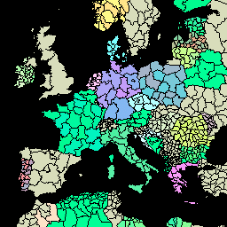
The Global Administrative Unit Layers (GAUL) compiles and disseminates the best available information on administrative units for all the countries in the world, providing a contribution to the standardization of the spatial dataset representing administrative units. The GAUL always maintains global layers with a unified … borders departments fao gaul infrastructure-boundaries provinces -
TIGER: US Census States 2016

The United States Census Bureau TIGER dataset contains the 2016 boundaries for the primary governmental divisions of the United States. In addition to the fifty states, the Census Bureau treats the District of Columbia, Puerto Rico, and each of the island areas (American Samoa, the … census infrastructure-boundaries state states table tiger -
TIGER: US Census States 2018
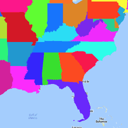
The United States Census Bureau TIGER dataset contains the 2018 boundaries for the primary governmental divisions of the United States. In addition to the fifty states, the Census Bureau treats the District of Columbia, Puerto Rico, and each of the island areas (American Samoa, the … census infrastructure-boundaries state states table tiger